A1079 road

Last updated

UK road A1079.svg
A1079
A1079 beverley eastbound enh.png
A1079 Beverley Bypass, looking eastbound towards Kingston upon Hull
Major junctions
From Kingston upon Hull
Major intersectionsUK road A63.svg A63
UK road A1105.svg A1105
UK road A165.svg A165
UK road A1165.svg A1165
UK road A1174.svg A1174
UK road A1033.svg A1033
UK road A164.svg A164
UK road A1035.svg A1035
UK road A1034.svg A1034
UK road A614.svg A614
UK road A166.svg A166
UK road A64.svg A64
UK road A1036.svg A1036
To York
Location
Country United Kingdom
Primary
destinations
Beverley
Road network
UK road A1078.svg A1078 UK road A1080.svg A1080

The A1079 is a major road in Northern England. It links the cities of York and Kingston upon Hull, both in Yorkshire. The road is noted for its past safety issues, and regularly features in the Road Safety Foundations reports on Britain's most dangerous roads. Campaigners have been calling for the entire route to be made into a dual carriageway.

Contents

Route

The road begins in central York, heading east initially as Lawrence Street and then Hull Road. After 2 miles (3.2 km) it meets the A64 at the congested grade separated Grimston Bar roundabout and gains primary status. [1] Continuing as Hull Road it passes Dunnington and Kexby, before heading into the East Riding of Yorkshire and passing Wilberfoss, Barmby Moor and Pocklington. [2] A roundabout at Pocklington Industrial Estate was constructed in 2011. [3] After going through Hayton the road becomes a dual carriageway for 1.5 miles (2.4 km), at the end of which is Shiptonthorpe, where the road becomes York Road. [4] This was a Roman Road between York and Brough, and when it was dualled, various Roman artefacts were uncovered. [5] It meets the A614 (to Goole and Bridlington) at a roundabout, before bypassing Market Weighton. The bypass was opened in 1991 – prior to this the road went through the town centre, originally being the York – Market Weighton turnpike road. [6] The bypass was built with one roundabout, at the junction with the A1034. A second roundabout, at Holme Road, was constructed in 2014. The road then goes through Bishop Burton before meeting the A1035 and A1174 at a roundabout west of Beverley at Killingwoldgraves. [7]

The section from Killingwoldgraves roundabout to the northern outskirts of Hull is known as the Beverley Bypass; [8] it passes around the southern side of Beverley, with a short dual carriageway section. The road crosses over the A164 (Beverley to Humber bridge) at a grade separated junction. It also bridges the Cottingham to Hull section of the Hull to Bridlington line, as well as the Cottingham to Dunwell road (Dunswell lane, underpassed). A new roundabout junction was constructed on the A1079 around 2011 for the Swift Leisure group caravan factory north of Cottingham, East Riding of Yorkshire. [9]

The Beverley Bypass section terminates at a roundabout junction (Dunswell roundabout) with the A1033 and A1174 road. Here the A1079 loses its primary status as it heads into the centre of Kingston upon Hull as Beverley Road and later, Ferensway. [10] The road terminates at the junction with the A63 (Hessle Road). [11]

About the road

Into the 1930s, the road continued past York on the course of what is now the A59, diverting at Green Hammerton and continuing to Boroughbrigde town centre, where it terminated at the Great North Road. [12] Much of the road is built to single carriageway standard, although a 1.1-mile (1.8 km) stretch of the Beverley bypass and a 1.5-mile (2.4 km) stretch near Shiptonthorpe are of dual carriageway standard. [13] [14] The majority of the road is national speed limit (60 mph / 97 km/h on single carriageway sections (including Market Weighton hill), 70 mph (110 km/h) / 113 km/h on dual carriageway sections).

Following its de-trunking in 2003, [15] the road is maintained by two authorities:

Safety

The road had a reputation for being dangerous, primarily because the majority of it is single carriageway. Cars therefore have to turn across oncoming traffic to access adjoining roads. Between 1999 and 2005, emergency statistics revealed that there had been 615 accidents. [16] A local campaign group Action Access A1079 (AAA1079) propose that in the long-term, more of the road be made dual carriageway to help combat these problems. [14]

In the European Road Assessment Programme survey, which gives all major roads in Europe a safety rating, the A1079 is categorised as 'Medium-high risk' between Market Weighton and Hull, and 'Low-medium risk' between York and Market Weighton . The Market Weighton-Hull section was also identified in a EuroRAP report in June 2007 as being one of the 10 most dangerous roads in the UK, with 69 fatal or serious collisions between 2003 and 2005. [17] In 2019, the A1079 was awarded a better safety record, now being identified as 'Low-Medium' risk for the section between York and Market Weighton, 'Medium' risk between Market Weighton and the outskirts of Hull. However the section through Hull is designated as a 'High-Risk' road. [18]

Related Research Articles

The A1 is the longest numbered road in the United Kingdom, at 410 miles (660 km). It connects London, the capital of England, with Edinburgh, the capital of Scotland. It passes through or near north London, Hatfield, Welwyn Garden City, Stevenage, Baldock, Letchworth Garden City, Biggleswade, St Neots, Huntingdon, Peterborough, Stamford, Grantham, Newark-on-Trent, Retford, Doncaster, York, Pontefract, Wetherby, Ripon, Darlington, Durham, Sunderland, Gateshead, Newcastle upon Tyne, Morpeth, Alnwick and Berwick-upon-Tweed.

<span class="mw-page-title-main">A21 road (England)</span> Major road in southern England running from London to Hastings

For other roads with the same name see List of A21 roads.

<span class="mw-page-title-main">A59 road</span> Road in Northern England

The A59 is a major road in England which is around 109 miles (175 km) long and runs from Wallasey, Merseyside to York, North Yorkshire. The alignment formed part of the Trunk Roads Act 1936, being then designated as the A59. It is a key route connecting Merseyside at the M53 motorway to Yorkshire, passing through three counties and connecting to various major motorways. The road is a combination of historical routes combined with contemporary roads and a mixture of dual and single carriageway. Some sections of the A59 in Yorkshire closely follow the routes of Roman roads, some dating back to the Middle Ages as salt roads, whilst much of the A59 in Merseyside follows Victorian routes which are largely unchanged to the present day.

<span class="mw-page-title-main">A63 road</span> Road in Yorkshire, England

The A63 is a major road in Yorkshire, England between Leeds and Kingston upon Hull. A section between North Cave and Hull forms the eastward continuation of the M62 motorway and is part of the unsigned Euroroute E20.

<span class="mw-page-title-main">Market Weighton</span> Town and civil parish in the East Riding of Yorkshire, England

Market Weighton is a town and civil parish in the East Riding of Yorkshire, England. It is one of the main market towns in the East Yorkshire Wolds and lies midway between Hull and York, about 20 miles (32 km) from either one. According to the 2011 UK census, Market Weighton parish had a population of 6,429, an increase on the 2001 UK census figure of 5,212.

<span class="mw-page-title-main">A614 road</span> Road in England

The A614 is a main road in England running through the counties of Nottinghamshire, South Yorkshire and the East Riding of Yorkshire.

<span class="mw-page-title-main">A64 road</span> Road in West and North Yorkshire, England

The A64 is a major road in North and West Yorkshire, England, which links Leeds, York and Scarborough. The A64 starts as the A64(M) ring road motorway in Leeds, then towards York it becomes a high-quality dual carriageway until it is east of York, where it becomes a single carriageway for most of its route to Scarborough.

<span class="mw-page-title-main">Skidby</span> Village and civil parish in the East Riding of Yorkshire, England

Skidby is a small village and civil parish in Yorkshire Wolds of the East Riding of Yorkshire, England. It is situated about 6 miles (10 km) north-west of Hull city centre, 2.2 miles (3.5 km) west of Cottingham and 5 miles (8 km) south of Beverley.

<span class="mw-page-title-main">Market Weighton Canal</span> Canal in the East Riding of Yorkshire, England

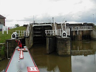
The Market Weighton Canal ran 9.5 miles (15.3 km) from the Humber Estuary to its terminus near Market Weighton. It gained its Act of Parliament in 1772 and opened in 1782. The 3.5 miles (5.6 km) closest to Market Weighton was abandoned in 1900 and the right of navigation through Weighton lock was lost in 1971. However, as of 2002 the lock was passable and the canal usable up to the junction with the River Foulness where silt has made it impassable. Also there is no right of navigation under the M62 motorway bridge to the north of Newport.

<span class="mw-page-title-main">Hull–Scarborough line</span> Railway line in Yorkshire, England

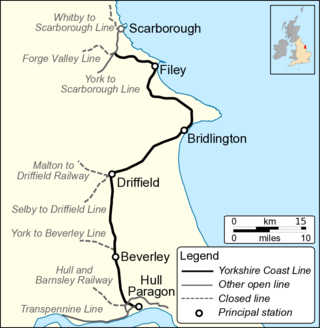
The Hull–Scarborough line, also known as the Yorkshire Coast Line, is a railway line in Yorkshire, England that is used primarily for passenger traffic. It runs northwards from Hull Paragon via Beverley and Driffield to Bridlington, joining the York–Scarborough line at a junction near Seamer before terminating at Scarborough railway station.

<span class="mw-page-title-main">A54 road</span> Road in England

The A54 road is a road in England linking Chester in Cheshire with Buxton in Derbyshire. Its route through both urban and steep rural areas presents a challenge to Cheshire County Council in maintaining the safety of the road. Many years ago it was the main east–west route in Cheshire. The importance of the A54 through Middlewich and Winsford decreased in the 1970s and 1980s with the building of the M56 motorway and dualling of the A556 at Northwich. The section through Winsford carries approximately 30,000 vehicles per day.

<span class="mw-page-title-main">A165 road</span> Road in Yorkshire, England

The A165 is a road that links Scarborough and Kingston upon Hull, both in Yorkshire, England. The road is designated as a Primary Route from its junction with the A64 in Scarborough to its southern terminus in Hull.

<span class="mw-page-title-main">Beverley Road</span> Road in Kingston upon Hull, England

Beverley Road is one of several major roads that run out of the city of Hull in the East Riding of Yorkshire, England. The road is noted for being a major arterial route into, and out of Hull. It also known for its student population and being the location of a shop (Turners), whose slogan was used by the pop band, Everything But the Girl. In 1994, just over 1-mile (1.6 km) of the road was designated as a conservation area.

<span class="mw-page-title-main">Shiptonthorpe</span> Village and civil parish in the East Riding of Yorkshire, England

Shiptonthorpe is a village and civil parish in the East Riding of Yorkshire, England. It is situated approximately 5 miles (8 km) south-east of the market town of Pocklington and 2 miles (3.2 km) north-west of the market town of Market Weighton.

<span class="mw-page-title-main">York–Beverley line</span> Former English railway line

The York–Beverley line was a railway line between York, Market Weighton and Beverley in Yorkshire, England. The line was sanctioned in 1846 and the first part, the York to Market Weighton Line opened in 1847. Construction of the second part to Beverley was delayed for 17 years in part by the downfall of George Hudson, and a less favourable financial environment following the collapse of the 1840s railway bubble; the North Eastern Railway revived and completed the scheme in the 1860s; the Market Weighton to Beverley Line opened in 1865.

<span class="mw-page-title-main">A1033 road</span> A road in the East Riding of Yorkshire, England

The A1033 road is a main arterial route across Kingston upon Hull and the East Riding of Yorkshire connecting Hull with Withernsea. The road carries traffic to and from the Port of Hull and Salt End at its western end, and local and holiday traffic at its eastern end. It is a primary route from the junction of the A63 road to the Salt End roundabout and is maintained on that section by National Highways. The section by the docks is also part of a designated abnormal load route.

National Cycle Network (NCN) Route 66 is a Sustrans National Route that runs from Kingston upon Hull to Manchester via Beverley, York and Leeds.

<span class="mw-page-title-main">River Foulness</span> River in the East Riding of Yorkshire, England

The River Foulness is a river in the East Riding of Yorkshire, England. Its name is derived from Old English fūle[n] ēa, meaning “dirty water”. Maintenance responsibilities for the river transferred from the Environment Agency to the Market Weighton Drainage Board on 1 October 2011. Market Weighton Drainage Board subsequently amalgamated with the Lower Ouse Internal Drainage Board on 1 April 2012 to create the Ouse and Humber Drainage Board. The river discharges into the Humber Estuary via Market Weighton Canal. Water levels within the river, its tributaries and the canal are managed and controlled by the Environment Agency. The river lies in an area known as the Humberhead Levels.

The York, Hull and East and West Yorkshire Junction Railway was a proposed railway line, promoted in the mid 1840s, intended to connect York to the East Riding of Yorkshire, England.

The York Outer Ring Road is a ring road around the city of York, England. The south-eastern section is part of the A64 and the north-western section is the A1237.
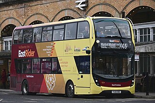
References

  1. "We want this new road now". York Press. 14 March 2006. Retrieved 15 April 2022.
  2. "294" (Map). Market Weighton & Yorkshire Wolds Central. 1:25,000. Explorer. Ordnance Survey. 2015. ISBN   978-0-319-24546-0.
  3. "New A1079 roundabout officially opened". York Press. 29 July 2011. Retrieved 15 April 2022.
  4. Copeland, Paul (7 July 2009). "A1079 road safety work to help reduce accidents". Hull Daily Mail. p. 14. ISSN   1741-3419.
  5. Johnson, Stephen; Curnow, Peter; Charlesworth, Dorothy; Pengelly, Hedley; Bayley, Justine; Monk, Juditch; Cook, Alison (1978). "Excavations at Hayton Roman Fort, 1975". Britannia. 9: 72. doi:10.2307/525938. JSTOR   525938. S2CID   164153457.
  6. Labrum, E. A (February 1993). "2. Humberside and North Lincolnshire". Civil Engineering Heritage Eastern and Central England. p. 44. doi:10.1680/ceheace.19706.0003. ISBN   0-7277-4607-3.
  7. "£6m for A1079 roundabouts as dual carriageway scheme shelved". BBC News. 25 January 2016. Retrieved 15 April 2022.
  8. "Beverley's southern relief road bypass Minster Way opens". BBC News. 12 March 2015. Retrieved 15 April 2022.
  9. "Boundary Business Park" (PDF). Met Engineers Ltd. Retrieved 7 June 2012.
  10. "Call for road change in Hull after traffic accident". BBC News. 1 June 2012. Retrieved 15 April 2022.
  11. "293" (Map). Kingston upon Hull & Beverley. 1:25,000. Explorer. Ordnance Survey. 2015. ISBN   978-0-319-24490-6.
  12. Cooper, Chris (2013). The Great North Road; then and now. Old Harlow: Battle of Britain International. p. 111. ISBN   1-870067-79-7.
  13. Eason, Kevin (19 May 1989). "Channon speeds up construction as spending on roads doubles to £12bn". The Times. No. 63398. London. p. 33. ISSN   0140-0460.
  14. 1 2 "MPs mount bid for A1079 upgrade". BBC News. 31 January 2007. Retrieved 15 April 2022.
  15. "The A1079 Trunk Road (Grimston Bar Interchange to City Boundary) (Detrunking) Order 2003" (PDF). legislation.gov.uk. Retrieved 15 April 2022.
  16. Stephens, Lucy (27 September 2006). "MPs lead drive for safer road". York Press. Retrieved 15 April 2022.
  17. Bell, Jennifer (24 April 2009). "A1079 among hazard Top Ten". York Press. Retrieved 15 April 2022.
  18. "How safe are you on Britain's main road networks?" (PDF). roadsafetyfoundation.org. p. 29. Retrieved 15 April 2022.

53°46′14″N0°21′16″W / 53.77063°N 0.35448°W / 53.77063; -0.35448