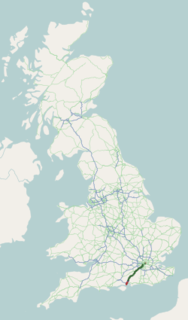
The A3, known as the Portsmouth Road or London Road in sections, is a major road connecting the City of London and Portsmouth passing close to Kingston upon Thames, Guildford, Haslemere and Petersfield. For much of its 67-mile (108 km) length, it is classified as a trunk road and therefore managed by National Highways. Almost all of the road has been built to dual carriageway standards or wider. Apart from bypass sections in London, the road travels in a southwest direction and, after Liss, south-southwest.
The A1 is the longest numbered road in the UK, at 396 miles (637 km). It connects London, the capital of England, with Edinburgh, the capital of Scotland. It passes through or near North London, Hatfield, Welwyn Garden City, Stevenage, Baldock, Letchworth Garden City, Biggleswade, St Neots, Huntingdon, Peterborough, Stamford, Grantham, Newark-on-Trent, Retford, Doncaster, York, Pontefract, Wetherby, Ripon, Darlington, Durham, Sunderland, Gateshead, Newcastle upon Tyne, Morpeth, Alnwick and Berwick-upon-Tweed.

The A38, parts of which are known as Devon Expressway, Bristol Road and Gloucester Road, is a major A-class trunk road in England.

The A68 is a major road in the United Kingdom, running from Darlington in England to the A720 in Edinburgh.

North Tyneside is a metropolitan borough in the metropolitan county of Tyne and Wear, England. It forms part of the greater Tyneside conurbation. North Tyneside Council is headquartered at Cobalt Park, Wallsend.

The A19 is a major road in England running approximately parallel to and east of the A1 road. Although the two roads meet at the northern end of the A19, the two roads originally met at the southern end of the A19 in Doncaster, but the old route of the A1 was changed to the A638. From Sunderland northwards, the route was formerly the A108. In the past the route was known as the East of Snaith-York-Thirsk-Stockton-on-Tees-Sunderland Trunk Road. Most traffic joins the A19, heading for Teesside, from the A168 at Dishforth Interchange.

The A69 is a major northern trunk road in England, running east–west across the Pennines, through the counties of Tyne and Wear, Northumberland and Cumbria. Originally, the road started in the centre of Newcastle upon Tyne then later near Birtley, but since the creation of the A1 Western Bypass around Newcastle upon Tyne, it now starts at Denton Burn, a suburb of Newcastle upon Tyne.

The A52 is a major road in the East Midlands, England. It runs east from a junction with the A53 at Newcastle-under-Lyme near Stoke-on-Trent via Ashbourne, Derby, Stapleford, Nottingham, West Bridgford, Bingham, Grantham, Boston and Skegness to the east Lincolnshire coast at Mablethorpe. It is approximately 147 miles (237 km) long.

The A167 and A167(M) is a road in North East England. It is partially a trunk road and partially a motorway, where it is commonly referred to as Newcastle Central Motorway. Most of the road’s route was formerly that of the A1, until it was re-routed with the opening of the A1(M) in the 1960s.
The M2 is a major highway and metropolitan route in Johannesburg, South Africa. It is named the Francois Oberholzer Freeway. It runs just to the south of the Johannesburg Central Business District eastwards where it connects with the N3 and enters Germiston, ending near its CBD. The north–south M1 intersects with the M2 just to the south-west of the Johannesburg CBD.

The A54 road is a road in England linking Chester in Cheshire with Buxton in Derbyshire. Its route through both urban and steep rural areas presents a challenge to Cheshire County Council in maintaining the safety of the road. Many years ago it was the main east–west route in Cheshire. The importance of the A54 through Middlewich and Winsford decreased in the 1970s and 1980s with the building of the M56 motorway and dualling of the A556 at Northwich. The section through Winsford carries approximately 30,000 vehicles per day.

The A1058, known locally as the Coast Road, is a major road in Newcastle upon Tyne and the adjoining borough of North Tyneside in the North East. It runs from the Newcastle Central Motorway to the coast, terminating between Whitley Bay and Tynemouth. From west to east it connects Newcastle city centre with Jesmond, Heaton, Wallsend, Battle Hill, Howdon, Meadow Well, North Shields, Whitley Bay and Tynemouth. The road has existed since December 1924, when it was opened by then-transport minister Wilfrid Ashley.

The A638 is a major road in England. It runs between the A1 at Markham Moor, Nottinghamshire and Chain Bar Interchange - Junction 26 of the M62 motorway, south of Bradford in West Yorkshire.

The A149 is commonly known as "The Coast Road" to local residents and tourists as this road runs along the North Norfolk coast from King's Lynn to Cromer passing through small coastal villages. The road then leaves the coastline at Cromer and reaches the Norfolk Broads.

The A183 road runs from South Shields in Tyne and Wear, through Sunderland and ends at Chester-le-Street in County Durham. It is a major route in South Tyneside, Sunderland and Chester-le-Street serving many areas and landmarks along its route.

The A1231 road connects Sunderland and Washington in Tyne and Wear, North East England. It is the main road connecting these towns and is one of the main roads giving access to Sunderland city centre.

The A1018 is a road in North East England. It runs between South Shields, at the mouth of the River Tyne, and the A19 near Seaham, County Durham. Most of the route it follows is the old alignment of the A19, before it by-passed Sunderland to meet the Tyne Tunnel.

The City of Peterborough in East Anglia has an extensive and well integrated road network, owing partly to its status as a new town. Since the 1960s, the city has seen considerable expansion and its various suburbs are linked by a system of parkways.

The A749 road in Scotland connects East Kilbride with Glasgow city centre via Rutherglen and Bridgeton.
The A1 road around Gateshead and Newcastle upon Tyne after arriving from the south as the A1(M) from its origin in London, currently runs from the A1(M) terminus at Birtley. It then swings to the west of both Gateshead and Newcastle via Coal House, Lobley Hill, Metrocentre, Swalwell, Blaydon Bridge, West Denton, Fawdon and Wideopen to Seaton Burn interchange before continuing north towards Edinburgh.


