The Walney to Wear and Whitby Cycle Route is the name of a cross-country cycle route in Northern England. It runs from Walney Island in Cumbria to Sunderland on the River Wear or Whitby.

The A689 is a road in northern England that runs east from the A595, 3.1 miles (5.0 km) to the west of Carlisle in Cumbria, to Hartlepool in County Durham.

Darlington Works was established in 1863 by the Stockton and Darlington Railway in the town of Darlington in the north east of England. The main part of the works, the North Road Shops was located on the northeast side of the Stockton and Darlington Railway
The A194 road is a road in Tyne and Wear, England. It runs northeast from its start at junction 65 of the A1(M) near Washington, and the first 3 miles (4.8 km) are motorway standard, designated the A194(M). There are intermediate junctions with the A182 and the A195 before the motorway section ends at the A184 junction. The junctions were unnumbered until 2013 when they were designated J1 to J3.

The A171 is a road in England that links the North Yorkshire towns of Middlesbrough, Guisborough, Whitby, Robin Hood's Bay and Scarborough. Locally it is known as The Moor Road. The road is mostly single carriageway but has some sections of dual carriageway. The distance between the two towns is 47 miles (75 km)

The A1058, known locally as the Coast Road, is a major road in Newcastle upon Tyne and the adjoining borough of North Tyneside in the North East. It runs from the Newcastle Central Motorway to the coast, terminating between Whitley Bay and Tynemouth. From west to east it connects Newcastle city centre with Jesmond, Heaton, Wallsend, Battle Hill, Howdon, Meadow Well, North Shields, Whitley Bay and Tynemouth. The road has existed since December 1924, when it was opened by then-transport minister Wilfrid Ashley.

The A591 is a major road in Cumbria, which lies almost entirely within the Lake District national park. A 2009 poll by satellite navigation firm Garmin named the stretch of the road between Windermere and Keswick as the most popular road in Britain. The 29.8 mile stretch between Kendal and Keswick was also named the UK's best driving road, according to a specially devised driving ratio formulated by car rental firm Avis.

The A1068 is a road in northern England that runs from Seaton Burn in North Tyneside to Alnwick in Northumberland. The section between Ellington and Alnmouth is signposted as part of the Northumberland Coastal Route.

The A685 is a road in Cumbria, England, that runs 28 miles (45 km) from Kendal to Brough.

The A172 is a major road in North Yorkshire, and the unitary authority of Middlesbrough, England. It runs from Ingleby Arncliffe to Middlesbrough. The road derives its adumbrated number from 1969 when a thoroughfare link connected South Teesside with the Lackenby Docks in Middlesbrough. Since further urban infrastructure development it has been extended into the North Yorkshire Moors, when it transforms into A174.

The A688 is a road in County Durham in North East England.
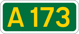
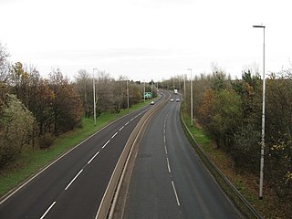
The A173 is a major road in North Yorkshire, England. It runs from Stokesley to Skelton.

The A588 is a road in western Lancashire, England, which runs for around 20 miles (32 km), from Poulton-le-Fylde northeastwards to Lancaster. It is the main route serving the Over Wyre areas of the Fylde.
The following radio stations broadcast on AM frequency 760 kHz: WJR in Detroit, Michigan, is the only class A station in North America broadcasting on 760 AM; 760 AM is a U.S. clear-channel frequency.
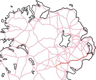
The A25 is the name given to the sections of the main route connecting Strangford with Castleblayney that lie in Northern Ireland. It is a road of regional importance, serving much of south Armagh and south Down. The road commences in the village of Strangford, on the shores of Strangford Lough, from which the Portaferry - Strangford Ferry service transports vehicles to Portaferry on the Ards peninsula. The entirety of the route is 61.2 miles, of which 54.5 miles are located north of the border, forming the A25 - the remaining 6.7 miles form the R182 in the Republic of Ireland.

The River Dorn is a river in Oxfordshire, England, that is a tributary of the River Glyme. The river rises from the limestone uplands of north Oxfordshire, about 1.5 miles (2.4 km) east of Chipping Norton (51.9587°N 1.4823°W), and flows southeast past Little Tew; through Sandford St. Martin, where it forms part of Sandford Park's gardens; and through the Bartons: Westcott Barton, Middle Barton, where Cockley Brook joins it, and Steeple Barton — before it joins the River Glyme just east of Wootton (51.8710°N 1.3554°W).

The Way of the Roses is a coast-to-coast long-distance cycle route of Great Britain and is based on minor roads, disused railway lines and specially constructed cycle paths. It lies entirely within the counties of Lancashire and Yorkshire, crossing the Yorkshire Dales and the Yorkshire Wolds in the North of England, passing through the historic cities of Lancaster, Ripon and York and scenic towns and villages including Settle and Pateley Bridge

A House Through Time is a documentary television series made by Twenty Twenty Television for BBC Two. The first series aired in 2018, a second in 2019, a third in 2020, and a fourth in 2021, with each examining the history of a single residential building in an English city. An upcoming fifth series was announced in 2023.
National Cycle Network (NCN) Route 656 is a Sustrans regional route in North Yorkshire. A 18.5 miles (29.8 km) cycle way between Coxwold and a junction with NCN Route 65 near Osmotherley via Sutton Bank National Park Centre and Hawnby. The route is fully opened and signed, it is on-road using quiet country lanes. Sustrans describe it as “a very strenuous route.”

National Cycle Network (NCN) Route 67 is a Sustrans National Route that runs from Long Whatton to Northallerton. The route is 124 miles (200 km) in length and is open but with sections missing.