The M181 is a motorway that links the town of Scunthorpe, England, to the M180 motorway. A spur of the M180, the road is virtually straight through its entire 2-mile (3.2 km) length. It was opened in December 1978, at the same time as the section of M180 from junction 3 (A15) to the east side of the River Trent.

Stocksbridge and Upper Don ward is one of the 28 electoral wards of the borough of Sheffield, South Yorkshire, England. The population of this ward was 18,541 at the 2011 Census.

The A499 road is the major road of the Llŷn peninsula in North Wales.

The A528 is a road that runs from Marchwiel, near Wrexham, in North Wales (53.0225°N 2.9597°W), to Shrewsbury, Shropshire, in England (52.7128°N 2.7512°W). On the way it passes through Ellesmere and Coton Hill. The road follows an old route that was Turnpiked in the 18th century.

The M621 is a 7.7-mile (12.4 km) loop of motorway in West Yorkshire, England that takes traffic into central Leeds between the M1 and M62 motorways.

The A630 is an A road in the United Kingdom. It runs between Sheffield city centre (53.3762°N 1.3998°W) and junction 4 of the M18 motorway (53.5400°N 1.0229°W), passing through Rotherham and Doncaster on the way. The road is entirely in South Yorkshire.

The A574 is a road in England, running through the borough of Warrington before terminating at the end of Butts Bridge in Leigh. The route covers a distance of approximately 13 miles (21 km) and links Warrington town centre with the outer suburbs of Birchwood and Sankey.

The A498 is a 16-mile road between Pen-y-Gwryd and Porthmadog in North Wales.

The A585 is a primary road in England which runs from Kirkham to Fleetwood in Lancashire.

The A643 is a main road between Leeds and Huddersfield in West Yorkshire, England. Its eastern end is at the Armley Gyratory roundabout on the western edge of Leeds City Centre. The road then goes through:

The A642 is an A-road in West Yorkshire, England which runs from Huddersfield to the A64 near Leeds. It partly follows the route of a historic turnpike road, which is evidenced by surviving toll houses.
The A632 is a major road in Derbyshire and Nottinghamshire, England. It starts in Matlock (53.1347°N 1.5485°W) and joins the town with Chesterfield. From there, it goes through Bolsover and then onto the A616 at the village of Cuckney (53.2336°N 1.1543°W).
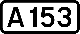
The A153 is a non-primary A road entirely in Lincolnshire in the east of England.

The A588 is a road in western Lancashire, England, which runs for around 20 miles (32 km), from Poulton-le-Fylde northeastwards to Lancaster. It is the main route serving the Over Wyre areas of the Fylde.

The A587 is a road in England that runs from Blackpool to Fleetwood in Lancashire.

The A586 is a road in Lancashire, England, which runs from Garstang to Blackpool.
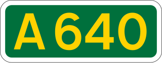
The A640 is a road in England which runs between Rochdale in Greater Manchester and Huddersfield in West Yorkshire.
The A658 is a road in Yorkshire, UK.

The A657 is an A road in West Yorkshire, England that begins in Bramley and ends in Saltaire near Shipley. The road is approximately 8 miles (13 km) long.

National Cycle Network (NCN) Route 647 is a Sustrans National Route that runs from Clumber Park to Harby 53.233°N 0.683°W. The route is 19.6 miles (31.5 km) in length and is fully open and signed in both directions.
This page is based on this
Wikipedia article Text is available under the
CC BY-SA 4.0 license; additional terms may apply.
Images, videos and audio are available under their respective licenses.