The A612 road is an A-class road in the United Kingdom running between Nottingham and Averham, on the A617 near Newark.
It starts in central Nottingham at a junction with the A60. Initially running east, as Pennyfoot Street, before a right turn sees it head southwards onto Manvers Street, a 4 lane single carriageway which was formerly a B road (B685). The road then crosses the main railway line out of Nottingham to the east over an early 1990s bridge (which again is 4 lane) before meeting Meadow Lane (here unclassified for approximately 100 metres, but further on the A6011) at a triangular roundabout.
After leaving the roundabout the road is two-lane dual carriageway with a 40mph (64km/h) speed limit for approximately 1,000 yards (910m). A further roundabout with Trent Street by a call centre for Virgin Media sees a change to 2 lane single carriageway, as it is for the remainder of its length, retaining the 40mph (64km/h) limit. After a further roundabout at Nottingham Racecourse, the limit changes to the national speed limit of 60mph (97km/h) until Colwick is reached, when it changes to 30mph (48km/h) to pass through a built up stretch.
Leaving Colwick the road becomes the Colwick Loop Road, which bypasses Netherfield, Carlton and Gedling. This section was also built national speed limit, but in May 2007 was reduced to 40mph (64km/h) concurrent with the opening of the Gedling bypass, or as it was described in the plans, "Gedling Integrated Transport Scheme". The former section of Colwick Loop Road bypassed by the scheme is now mapped as the A6211, but is unsigned at ground level.
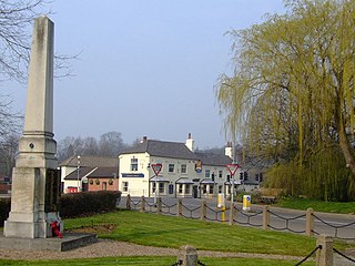
Rejoining the former route at a signalled T-junction, we enter Burton Joyce. Initially a 40mph (64km/h) limit, approaching the village centre the limit is reduced to 30mph (48km/h). Here, a 1930s bypass would previously have bypassed the bulk of the village but now almost bisects it, as development has spread across the road. Bypassing Bulcote, the road is then 60mph (97km/h) again as it opens out towards a roundabout junction with the A6097 at Lowdham.
After leaving Lowdham the road is again open single carriageway with a 60mph (97km/h) limit. Gonalston is bypassed, and then we pass through Thurgarton, up a steep hill before the road becomes 60mph (97km/h) again. The road between Thurgarton and Southwell is relatively undulating and bendy.
Entering Southwell from the south-west, passing the leisure centre, we then meet the B6386 at a T-junction where you need to turn off the A612 to stay on the numbered route. After passing the West gate to Southwell Minster, the road turns right at a mini roundabout by the Saracen's Head public house and passes the north side of the Minster. A further sharp bend to the left allows us to pass another racecourse, this time Southwell Racecourse, before exiting Southwell past the former workhouse which is now a museum.
Heading east through Upton, past a property owned by the British Horological Society, we meet the A617 near Averham at a signalled T-junction, signalling the end of the route.
Plans have been drawn up by Nottinghamshire County Council to bypass Southwell. The plans have existed since before 1990. The County Council has acquired a number of parcels of land in the line of the plan. However, considerable opposition is building up to the plan. Southwell residents are arguing that the 'line' of the bypass will become a new edge of town, and allow considerable expansion of the urban edge of the town, into the sensitive southern aspect. This is the view which includes the historic town centre and views of the Southwell Minster.
New traffic measures are suggested as an alternative to reduce through traffic, such as an HGV ban except for access, and downgrading this inappropriate route from Lowdham to Newark, to B road status. Through traffic should be directed at Lowdham and Newark to the newly dualled A46.
Former routes
The 1922 designation of the A612 had the terminus on the A617 in Southwell, not Averham. The latter passed through Farnsfield, Edingley and Halam, before meeting the A612 in Southwell and continuing through Upton to Newark.
Through Nottingham, the A612 (until the Manvers Street bridge was opened in the early 1990s) passed through Sneinton, Carlton and Gedling, along what is now the B686.
In 2007, following the opening of the Gedling bypass, the bypassed section became A6211 then unclassified. The former route under the railway bridge, and a length of Stoke Lane, are closed to through traffic by using bus plugs. These are traffic signals permanently on a red light unless a bus is passing through it. The restriction has caused controversy amongst local residents especially in the Nottingham Evening Post.
In 2011 The 'Bus Plugs' were opened to normal traffic. The traffic signals are still present but change when any vehicle approaches them.
The reopening of the bus plug still causes controversy with many Councillors and locals questioning the validity
The A3, known as the Portsmouth Road or London Road in sections, is a major road connecting the City of London and Portsmouth passing close to Kingston upon Thames, Guildford, Haslemere and Petersfield. For much of its 67-mile (108 km) length, it is classified as a trunk road and therefore managed by National Highways. Almost all of the road has been built to dual carriageway standards or wider. Apart from bypass sections in London, the road travels in a southwest direction and, after Liss, south-southwest.
The M1 motorway connects London to Leeds, where it joins the A1(M) near Aberford, to connect to Newcastle. It was the first inter-urban motorway to be completed in the UK; the first motorway in the country was the Preston Bypass, which later became part of the M6.
The A38, parts of which are known as Devon Expressway, Bristol Road and Gloucester Road, is a major A-class trunk road in England.
The A12 is a major road in Eastern England. It runs north-east/south-west between London and the coastal town of Lowestoft in the north-eastern corner of Suffolk, following a similar route to the Great Eastern Main Line until Ipswich. A section of the road between Lowestoft and Great Yarmouth became part of the A47 in 2017. Between the junctions with the M25 and the A14, the A12 forms part of the unsigned Euroroute E30. Unlike most A roads, this section of the A12, together with the A14 and the A55, has junction numbers as if it were a motorway.
The A77 road is a major road in Scotland. It runs in a southwesterly direction from the city of Glasgow, past the towns of Giffnock, Newton Mearns, Kilmarnock, Prestwick, Ayr, Girvan and Stranraer to the village of Portpatrick on the Irish Sea. It passes through the council areas of Glasgow City, East Renfrewshire, East Ayrshire, South Ayrshire and Dumfries and Galloway.
The A55, also known as the North Wales Expressway, is a major road in Wales and England, connecting Cheshire and North Wales. The vast majority of its length from Chester to Holyhead is a dual carriageway primary route, with the exception of the Britannia Bridge over the Menai Strait and several short sections where there are gaps in between the two carriageways. All junctions are grade separated apart from a roundabout east of Penmaenmawr and another nearby in Llanfairfechan. Initially, the road ran from Chester to Bangor. In 2001, it was extended across Anglesey to the ferry port of Holyhead parallel to the A5. The road improvements have been part funded with European money, under the Trans-European Networks programme, as the route is designated part of Euroroute E22.
The A52 is a major road in the East Midlands, England. It runs east from a junction with the A53 at Newcastle-under-Lyme near Stoke-on-Trent via Ashbourne, Derby, Stapleford, Nottingham, West Bridgford, Bingham, Grantham, Boston and Skegness to the east Lincolnshire coast at Mablethorpe. It is approximately 147 miles (237 km) long.
Carlton is a town in the Borough of Gedling, Nottinghamshire, England. It is to the east of Nottingham. The population at the 2011 Census was 6,881. It was an urban district until 1974, whose wards had an estimated population of 48,416 in 2015. Owing to the growth of residential, commercial and industrial in the wider Gedling Borough, City of Nottingham, Borough of Broxtowe, Rushcliffe and Ashfield District, as well as the Amber Valley and Borough of Erewash in Derbyshire which have become quite urban around Nottingham, Carlton and Gedling, as well as Netherfield form a contiguous urban area.
A dual carriageway (BrE) or a divided highway (AmE) is a class of highway with carriageways for traffic travelling in opposite directions separated by a central reservation (BrE) or median (AmE). Roads with two or more carriageways which are designed to higher standards with controlled access are generally classed as motorways, freeways, etc., rather than dual carriageways.
Lowdham is a village and civil parish in the Newark and Sherwood district of Nottinghamshire between Nottingham and Southwell. At the 2001 census it had a population of 2,832, increasing to 3,334 at the 2011 Census. Two main roads slicing through the village are the A6097 south-east to north-west and the A612 between Nottingham and Southwell.
The A17 road is a mostly single carriageway road linking Newark-on-Trent in Nottinghamshire, England, to King's Lynn in Norfolk. It stretches for a distance of 62 miles travelling across the flat fen landscapes of southern Lincolnshire and western Norfolk and links the East Midlands with East Anglia. The road is notable for its numerous roundabouts and notoriously dangerous staggered junctions and also for its most famous landmark, the Cross Keys Bridge at Sutton Bridge close to the Lincolnshire/Cambridgeshire/Norfolk borders which carries the road over the River Nene.
Gedling is a village and former civil parish which gives its name to the larger Borough of Gedling in Nottinghamshire, England. It lies 4 miles (6.4 km) north-east of Nottingham city centre. The parish was abolished in 1935 and absorbed into the urban district of Carlton, which in turn was abolished in 1974 on the creation of borough of Gedling. The population of the Gedling ward at the 2011 census was 6,817 and 111,787 for the district. Gedling was recorded in the Domesday Book and is still a distinct settlement, although residential, commercial and industrial growth in the wider borough of Gedling and the neighbouring city of Nottingham, boroughs of Broxtowe and Rushcliffe and district of Ashfield means it can be difficult to distinguish the village of Gedling from the nearby town of Carlton, with which it has become contiguous.
Netherfield is a town in the Borough of Gedling in Nottinghamshire, England. It is situated to the east of Nottingham's city boundary and is approximately 3 miles (4.8 km) between Colwick and Carlton in the NG4 postcode area, and near the River Trent. The appropriate Gedling ward was called 'Netherfield and Colwick' until boundary reorganisation in 2015, when it became 'Netherfield', with 'Colwick' becoming a separate ward.. At the time of the 2011 census, the population of this ward was 7,398.
The A1079 is a major road in Northern England. It links the cities of York and Kingston upon Hull, both in Yorkshire. The road is noted for its past safety issues, and regularly features in the Road Safety Foundations reports on Britain's most dangerous roads. Campaigners have been calling for the entire route to be made into a dual carriageway.
The A556 is a road in England which extends from the village of Delamere in Cheshire West and Chester to the Bowdon Interchange in Cheshire East, bordering Greater Manchester. The road contains a mixture of single and dual carriageway sections and forms a large part of the route between Manchester and Chester. It also acts as a major access route to Chester/North Wales to the west and to Manchester to the east for the conurbation of towns and villages around the Dane Valley centering on Winsford and Northwich. The central part, which forms the Northwich Bypass between Davenham and Lostock Gralam, suffers because of the amount of commuter traffic from this area. The part of the route between the M6 motorway Junction 19 and the M56 motorway Junction 7 is a major route into Manchester and has been recently upgraded to a four-lane dual carriageway.
The A240 is a partially primary status A road in Surrey and Greater London that connects the A217 with the A3 and continues beyond through Surbiton to Kingston upon Thames. The road is 8.5 miles (13.7 km) long and is dualled as the Ewell bypass and thereafter to Tolworth Broadway. In conjunction with the A3 it provides an alternative to the congested A24 corridor through Morden and Merton.
The A146 is an A road that connects Norwich in Norfolk and Lowestoft in Suffolk, two of East Anglia's largest population centres. It is around 27 miles (43 km) in length and has primary classification along its entire route. It is mainly single carriageway throughout its route, with the exception of a section of dual carriageway on the southern edge of Norwich.
The A572 is a main road serving the Greater Manchester and Merseyside areas, running from Swinton to St Helens via Leigh and Newton-le-Willows.
The A616 is a road that links Newark-on-Trent, Nottinghamshire, to the M1 motorway at Junction 30, then reappears at Junction 35A and goes on to Huddersfield, West Yorkshire.
The A617 road runs through the northern East Midlands, England, between Newark-on-Trent and Chesterfield.
This page is based on this Wikipedia article Text is available under the CC BY-SA 4.0 license; additional terms may apply. Images, videos and audio are available under their respective licenses.