
Southwell is a minster and market town in the district of Newark and Sherwood in Nottinghamshire, England. It is home to the grade-I listed Southwell Minster, the cathedral of the Anglican Diocese of Southwell and Nottingham. The population of the town was recorded at 7,491 in the 2021 census. The town is on the River Greet and is located geographically 9 miles (14 km) west of Newark on Trent, 15 miles (24 km) northeast of Nottingham, 13 miles (21 km) southeast of Mansfield and 22 miles (35 km) southeast of Worksop.

West Leake is a small conservation village and civil parish in the Rushcliffe district of Nottinghamshire.

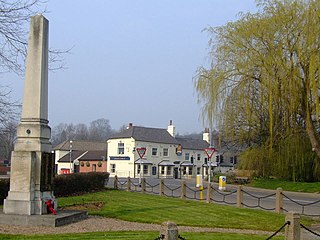
Burton Joyce is a large village and civil parish in the Gedling district of Nottinghamshire, England, 7 miles (11 km) east of Nottingham, between Stoke Bardolph to the south and Bulcote to the north-east. The A612 links it to Carlton and Netherfield to the south-west and Lowdham to the north-east. Initially the site of an Iron age fort, it was occupied by Norman nobility, who founded St Helen's Church. From being a farming community, Burton Joyce grew in the early Industrial Revolution, earning repute up to the 1920s for its textile products. Many of today's 3,443 inhabitants commute to work in Nottingham. It forms with Stoke Bardoph and Bulcote the Trent Valley ward of Gedling, with two councillors.
Lowdham is a village and civil parish in the Newark and Sherwood district of Nottinghamshire between Nottingham and Southwell. At the 2001 census it had a population of 2,832, increasing to 3,334 at the 2011 Census. Two main roads slicing through the village are the A6097 south-east to north-west and the A612 between Nottingham and Southwell.

Epperstone is an English village and civil parish in mid-Nottinghamshire, located near Lowdham and Calverton. It had a population of 589 at the time of the 2011 census, falling to 517 at the 2021 census. Many inhabitants commute to work or school in Nottingham 9 miles (16 km) to the south-west.
Kneeton is a village in the county of Nottinghamshire, England. The population as of the 2011 census remained less than 100. It is included in the civil parish of Screveton. The village lies on the A46 road between Nottingham and Newark and is on the escarpment of the Trent Hills that sit above the flood plain of the River Trent. RAF Syerston is nearby. There is a railway station at Lowdham. The church is 14th century Grade II listed, and dedicated to St. Helen. A mid-18th century Grade II listed barn survives at Hall Farm, Kneeton.

Thurgarton is a small village in rural Nottinghamshire, England. The village is close to Southwell, and Newark-on-Trent and still within commuting distance to Nottingham. It is served by Thurgarton railway station. According to the 2001 census it had a population of 412, increasing to 440 at the 2011 census.

Farndon is a small village and civil parish in Newark and Sherwood district of Nottinghamshire, England. It lies along the historic Fosse road on the banks of the River Trent and is 3 miles (4 km) south-west of Newark-on-Trent. The population of the civil parish as of the 2011 census was 2,405, this increased to 2,479 at the 2021 census. The A46 road previously ran through the village until the development of a new dual carriageway bypass.

Flintham is a village and civil parish in the Rushcliffe district in Nottinghamshire, 7 miles from Newark-on-Trent and opposite RAF Syerston on the A46. It had a population of 597 at the 2011 Census and estimated at 586 in 2019. The village name was taken by the Ham class minesweeper HMS Flintham.
Upton is a small village in Nottinghamshire, England, 2 miles (3.2 km) east of Southwell, 5 miles (8.0 km) west of Newark and 3 miles (4.8 km) south of Hockerton; it lies on the A612 Nottingham-Newark road. In 1889, the village was described as sitting on a bend in the main road, "on the summit of a hill which commands a fine view of the Trent Valley.... The church, which is a prominent feature in the landscape, has a substantial Perpendicular tower crowned by eight pinnacles, and having in the centre a lofty master pinnacle which rises above its neighbours, and so adds materially to the effect."
Clipston, or Clipston on the Wolds, is a small English village and civil parish in the south Nottinghamshire district of Rushcliffe. It lies between Cotgrave and Normanton-on-the-Wolds and is approached by narrow roads that offer views of neighbouring countryside. It has an area of 951 acres (3.85 km2) and a population of 50. This meant it was included with the civil parish of Tollerton in the 2011 Census.

Hawton is an English village and civil parish in Nottinghamshire, about two miles (3.2 km) south of town of Newark-on-Trent, near the River Devon, a tributary of the River Trent. Its population was recorded as 147 in the 2011 Census.
Kelham is a small village and civil parish in Nottinghamshire about 3 miles (4.8 km) northwest of Newark on a bend in the A617 road near its crossing of the River Trent. The population of the civil parish taken at the 2011 census was 207.

Oxton is a village in Nottinghamshire, England, with a 568 residents at the 2011 census. It is located 5 miles (8 km) west of Southwell, 5 miles (8 km) north of Lowdham, 10 miles (16 km) north-east of Nottingham and 2 miles (3 km) north-east of Calverton, and lies on the B6386, and is very close to the A6097 trunk road.

Thorpe is a Nottinghamshire village or hamlet lying to the east of East Stoke about a mile off the A46 Fosse Way, and situated in the countryside southwest of Newark.
Rolleston is a small village and civil parish in Nottinghamshire by the River Greet, a few miles from Southwell not far from the Trent and about 5 miles (8.0 km) southwest of Newark. The population of the civil parish at the 2011 census was 312. It has a church dedicated to the Holy Trinity. It lies close to the railway line between Nottingham and Lincoln with a station serving the village and Southwell as well as the nearby Southwell Racecourse.
Hawksworth is an English conservation village and civil parish in the Rushcliffe borough of Nottinghamshire. It lies 10 miles (16 km) south of Newark-on-Trent, adjacent to the villages of Flintham, Sibthorpe, Thoroton, Scarrington and Screveton.
Elton on the Hill is a small Nottinghamshire village and civil parish in the Vale of Belvoir. The population of about 75 is included with the civil parish of Granby for census purposes.

St Michael and All Angels' Church, Elton on the Hill is a parish church in the Church of England in Elton on the Hill, Nottinghamshire. It is Grade II listed by the Department for Digital, Culture, Media and Sport as a building of special architectural interest.

St. Lawrence's Church, Thorpe is a parish church in the Church of England in Thorpe, Nottinghamshire.


