Newark and Sherwood

Last updated

Newark and Sherwood
Sherwood Forest (9526).jpg
Ollerton - Church from Station Road - geograph.org.uk - 2369314.jpg
Rufford Abbey Cistercian monastery, monastic precinct, water-management works, pre-monastic open-field system and post-medieval (2).jpg
SyerstonTower-203.jpg
The Spire of St Mary Magdalene Church viewed from The Market Square, Newark - geograph.org.uk - 4558800.jpg
Southwell Minster.jpg
Newark and Sherwood UK locator map.svg
Shown within Nottinghamshire
Sovereign state United Kingdom
Constituent country England
Region East Midlands
Administrative county Nottinghamshire
Admin. HQ Newark-on-Trent [1]
Government
  TypeNewark and Sherwood District Council
   MPs: Robert Jenrick,
Michelle Welsh
Area
  Total
251 sq mi (651 km2)
  Rank 52nd
Population
 (2022)
  Total
125,089
  Rank Ranked 192nd
  Density500/sq mi (190/km2)
Ethnicity (2021)
[2]
   Ethnic groups
List
Religion (2021)
[2]
   Religion
List
Time zone UTC+0 (Greenwich Mean Time)
  Summer (DST) UTC+1 (British Summer Time)
ONS code 37UG (ONS)
E07000175 (GSS)
Ethnicity98.5% White

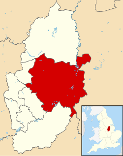
Newark and Sherwood is a local government district in Nottinghamshire, England. It is the largest district by area in the county. The council is based in Newark-on-Trent, the area's largest town. The district also includes the towns of Southwell and Ollerton along with a large rural area containing many villages. Much of the district lies within the ancient Sherwood Forest and there are also extensive forestry plantations in the area.

Contents

The neighbouring districts are Rushcliffe, Gedling, Ashfield, Mansfield, Bassetlaw, West Lindsey, North Kesteven, South Kesteven and Melton. In 2021 it had a population of 123,383.

History

The district was created on 1 April 1974 under the Local Government Act 1972, covering three former districts which were all abolished at the same time: [3]

The new district was initially named Newark, after its largest town. [4] The name was changed to Newark and Sherwood in 1985. [5]

Governance

Newark and Sherwood District Council
Newark & Sherwood District Council.svg
Type
Type
Leadership
Linda Tift,
Labour
since 20 May 2025 [6]
Paul Peacock,
Labour
since 23 May 2023
John Robinson
since 23 July 2018 [7]
Structure
Seats39 councillors
United Kingdom Newark and Sherwood District Council 2025.svg
Political groups
Administration (19)
  Labour (10)
  Liberal Democrat (3)  Independent (6)
Other parties (20)
  Conservative (12)
  Green (2)
  Independent (6)
Elections
First past the post
Last election
4 May 2023
Next election
6 May 2027
Meeting place
Castle House, Great North Road, Newark, NG24 1BY
Website
www.newark-sherwooddc.gov.uk
Map of Newark and Sherwood district. UK Newark and Sherwood District 2024 Map.svg
Map of Newark and Sherwood district.

Newark and Sherwood District Council provides district-level services. County-level services are provided by Nottinghamshire County Council. The whole district is also covered by civil parishes, which form a third tier of local government. [8]

Political control

The council has been under no overall control since the 2023 election, being run by a partnership of Labour, the "Independents for Newark and District" group of independent councillors, and the Liberal Democrats. [9]

The first election to the council was held in 1973, initially operating as a shadow authority alongside the outgoing authorities before coming into its powers on 1 April 1974. Since 1974 political control of the council has been as follows: [10] [11]

Party in controlYears
Labour 1974–1976
Conservative 1976–1979
No overall control 1979–1991
Labour 1991–1999
No overall control 1999–2007
Conservative 2007–2023
No overall control 2023–present

Leadership

The leaders of the council since 2003 have been:

CouncillorPartyFromTo
Tony Roberts [12] Conservative 200315 May 2012
Roger Blaney [12] [13] Conservative 15 May 2012May 2018
David Lloyd [14] [15] Conservative May 2018May 2023
Paul Peacock [16] Labour 23 May 2023

Composition

Following the 2023 election, [17] and subsequent changes of allegiance up to May 2025, the composition of the council was:

PartyCouncillors
Conservative 14
Labour 10
Independent 10
Liberal Democrats 3
Green 2
Total39

Of the ten independent councillors, six sit together as the "Independents for Newark and District" group, which forms part of the council's administration with Labour and the Liberal Democrats. Another two independents form the "Newark and Sherwood District Independents" group, and the other two do not belong to any group. [18] The next election is due in 2027. [19]

Elections

Since the last full review of boundaries in 2015 the council has comprised 39 councillors representing 21 wards, with each ward electing one, two or three councillors. Elections are held every four years. [20]

The district is covered by two parliamentary constituencies: Newark, created in 1885, which has been represented by Robert Jenrick, a Conservative, since 2014; [21] and has been held by the Conservative Party since 2001; [22] and Sherwood Forest, created in 1983, represented by Michelle Welsh, a Labour MP, elected in 2024.

Premises

The council is based at Castle House, on Great North Road in Newark, adjacent to Newark Castle Railway station. The building was purpose-built for the council and opened in 2017. [23]

Kelham Hall: Council's headquarters 1974-2017 Kelham Hall.jpg
Kelham Hall: Council's headquarters 1974–2017

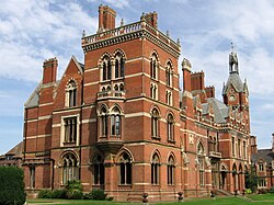
The council was previously based at Kelham Hall in the village of Kelham, which had been purchased early in 1974 as part of preparations for the local government reorganisation later that year. [24] [25] [26]

Settlements

Ollerton, the second largest settlement in Newark and Sherwood Ollerton - White Hart Hotel - geograph.org.uk - 2369301.jpg
Ollerton, the second largest settlement in Newark and Sherwood
Southwell, home of Southwell Minster and the third-largest settlement in the district Southwell NG25, Notts. - geograph.org.uk - 3471337.jpg
Southwell, home of Southwell Minster and the third-largest settlement in the district
Edwinstowe, a village which legends link with Robin Hood St Mary's Church, Church Street, Edwinstowe (1).jpg
Edwinstowe, a village which legends link with Robin Hood

The whole district is divided into civil parishes. The parish councils for the three parishes of Newark, Ollerton and Boughton, and Southwell have declared[ when? ] their parishes to be towns, allowing them to take the style "town council". [27]

Newark-on-Trent, together with Balderton, forms the largest urban area in the district. Newark-on-Trent has many important historic features including Newark Castle, St Mary's Magdalene Church, Georgian architecture and a defensive earthwork from the British Civil Wars. Other important towns in the district include Ollerton and Southwell which is home to Southwell Minster and Southwell Racecourse. Other settlements in the district include:

Averham
Balderton, Bathley, Beacon, Bilsthorpe, Blidworth, Boughton, Bridge, Brough
Carlton-on-Trent, Castle, Caunton, Clipstone, Collingham, Cromwell
Devon
Eakring, Edingley, Edwinstowe, Egmanton
Farndon, Farnsfield, Fernwood, Fiskerton
Gunthorpe
Halam, Halloughton, Hawton, Hockerton
Kelham, Kirklington, Kirton, Kneesall
Laxton, Little Carlton, Lowdham
Magnus, Maplebeck, Morton
North Muskham, Norwell
Ossington, Oxton
Perlethorpe
Rainworth, Rolleston
Sleaford, South Muskham, Sutton-on-Trent
Thurgarton
Upton
Walesby, Wellow, Weston, Winkburn

Media

Television

The area is served by BBC East Midlands and ITV Central with television signals are received from the Waltham TV transmitter, [28] BBC Yorkshire and Lincolnshire and ITV Yorkshire can also be received from the Belmont TV transmitter. [29]

Radio

Radio stations that broadcast to the area are:. [30]

BBC Local Radio

Independent Radio

Community Radio

References

  1. "Castle House". newark-sherwooddc.gov.uk. Newark and Sherwood District Council. Archived from the original on 14 June 2020. Retrieved 14 June 2020.
  2. 1 2 UK Census (2021). "2021 Census Area Profile – Newark and Sherwood see Local Authority (E07000175)". Nomis. Office for National Statistics . Retrieved 5 January 2024.
  3. "The English Non-metropolitan District (Definition) Order 1972", legislation.gov.uk , The National Archives, SI 1972/2039, retrieved 17 November 2023
  4. "The English Non-metropolitan Districts (Names) Order 1973", legislation.gov.uk , The National Archives, SI 1973/551, retrieved 31 May 2023
  5. "Historical information on changes to electoral arrangements of Local authorities, Parliamentary areas and European Parliamentary boundaries". Boundary-Line Downloads. Ordnance Survey. Retrieved 25 August 2025. (See downloadable boundary-legislation-changes-from-1973.xls spreadsheet.)
  6. Armitage, Rachel (22 May 2025). "Linda Tift, of the Rainworth North and Rufford ward, voted new chairman of Newark and Sherwood District Council, with Dover Beck ward member Roger Jackson as vice chairman". Newark Advertiser. Retrieved 18 June 2025.
  7. Churcher, Dan (6 April 2018). "New chief executive for district council". Newark Advertiser. Retrieved 25 December 2023.
  8. "Local Government Act 1972", legislation.gov.uk , The National Archives, 1972 c. 70, retrieved 31 May 2023
  9. Gilmore, Eloise (24 May 2023). "Labour's Paul Peacock appointed as executive leader of Newark and Sherwood District Council after shock election saw Conservatives lose majority". Newark Advertiser. Retrieved 25 December 2023.
  10. "Compositions Calculator". The Elections Centre. University of Exeter. Retrieved 21 May 2025. (Put "Newark & Sherwood" in search box to see specific results.)
  11. "Newark & Sherwood". BBC News Online . Retrieved 25 September 2009.
  12. 1 2 Buckland, Laurey (18 April 2012). "Leader takes a back seat". Newark Advertiser. Retrieved 20 August 2022.
  13. "Roger Blaney". Newark Conservatives. Retrieved 18 June 2025.
  14. "Use the three Ls for priorities". Newark Advertiser. 24 May 2018. Retrieved 18 June 2025.
  15. Gilmore, Eloise (24 May 2023). "Labour's Paul Peacock appointed as executive leader of Newark and Sherwood District Council after shock election saw Conservatives lose majority". Newark Advertiser. Retrieved 18 June 2025.
  16. "Council minutes, 23 May 2023". Newark and Sherwood District Council. Retrieved 18 June 2025.
  17. "Local elections 2023: live council results for England". The Guardian.
  18. "Your Councillors by Party". Newark and Sherwood District Council. Retrieved 25 December 2023.
  19. "Newark and Sherwood". Local Councils. Thorncliffe. Retrieved 18 June 2025.
  20. "The Newark and Sherwood (Electoral Changes) Order 2014", legislation.gov.uk , The National Archives, SI 2014/1907, retrieved 25 December 2023
  21. "Newark by-election candidate names confirmed". BBC News. 13 May 2014. Retrieved 6 September 2021.
  22. "Electdata 2001". 15 October 2011. Archived from the original on 15 October 2011. Retrieved 6 September 2021.
  23. "New Council Offices to open 25th September". Radio Newark. 5 September 2017. Retrieved 25 December 2023.
  24. "Kelham Hall bid accepted". Nottingham Evening Post. 14 January 1974. Retrieved 25 December 2023 via findmypast.co.uk.(subscription required)
  25. "Grade I-listed Kelham Hall conversion 'will create 80 jobs'". BBC News. 27 November 2014. Retrieved 6 August 2021.
  26. "Kelham Hall sale confirmed by Newark council". BBC News. 25 June 2014. Retrieved 6 August 2021.
  27. "Parish and Town Councils". Newark and Sherwood District Council. Retrieved 25 December 2023.
  28. "Full Freeview on the Waltham (Leicestershire, England) transmitter". UK Free TV. 1 May 2004. Retrieved 28 May 2024.
  29. "Belmont (Lincolnshire, England) Full Freeview transmitter". UK Free TV. 1 May 2004. Retrieved 28 May 2024.
  30. "Local news and radio". Nottinghamshire County Council. Retrieved 28 May 2024.
  31. "Radio Newark" . Retrieved 28 May 2024.
  32. "Bowe Radio" . Retrieved 28 May 2024.

53°06′N0°57′W / 53.10°N 0.95°W / 53.10; -0.95