| Name | Status | Image | Population (2011) [32] | Ward(s) |
|---|
| Retford | Unparished
(Charter trustees) | | 22,023 | - Retford East
- Retford North
- Retford South
- Retford West
|
| Worksop | Unparished
(Charter trustees) | | 43,252 | - Worksop East
- Worksop North
- Worksop North East
- Worksop North West
- Worksop South
- Worksop South East
|
| Askham | Civil parish |  St. Nicholas' Church, Askham St. Nicholas' Church, Askham | 181 | East Markham |
| Babworth | Civil parish |  Chesterfield Canal, Babworth Chesterfield Canal, Babworth | 1,687 | Sutton |
| Barnby Moor | Civil parish |  Ye Olde Bell, Barnby Moor Ye Olde Bell, Barnby Moor | 278 | Sutton |
| Beckingham | Civil parish |  All Saints' Church, Beckingham All Saints' Church, Beckingham | 1,098 | Beckingham |
| Bevercotes | Civil parish |  Farm buildings in Bevercotes Farm buildings in Bevercotes | Unknown | East Markham |
| Blyth | Civil parish |  St Mary and St Martin's Church, Blyth St Mary and St Martin's Church, Blyth | 1,233 | Blyth |
| Bole | Civil parish |  St Martin's Church, Bole St Martin's Church, Bole | 247 | Sturton |
| Bothamsall | Civil parish |  Lound Hall, Bothamsall Lound Hall, Bothamsall | 270 | East Markham |
| Carburton | Civil parish |  Ollerton Road Bridge, Carburton Ollerton Road Bridge, Carburton | Unknown | Welbeck |
| Carlton in Lindrick | Civil parish |  St. John's Church, Carlton in Lindrick St. John's Church, Carlton in Lindrick | 5,623 | Carlton |
| Clarborough and Welham | Civil parish |  Public house in Clarborough Public house in Clarborough | 1,088 | Clayworth |
| Clayworth | Civil parish |  St Peter's Church, Clayworth St Peter's Church, Clayworth | 419 | Clayworth |
| Clumber and Hardwick | Civil parish | | Unknown | Welbeck |
| Cottam | Civil parish |  Cottages in Cottam Cottages in Cottam | 108 | Rampton |
| Darlton | Civil parish |  St. Giles Church, Darlton St. Giles Church, Darlton | 110 | Tuxford and Trent |
| Dunham-on-Trent | Civil parish |  St. Oswald's Church, Dunham-on-Trent St. Oswald's Church, Dunham-on-Trent | 343 | Tuxford and Trent |
| East Drayton | Civil parish |  St. Peter's Church, East Drayton St. Peter's Church, East Drayton | 252 | Tuxford and Trent |
| East Markham | Civil parish |  St. John the Baptist Church St. John the Baptist Church | 1,160 | East Markham |
| Eaton | Civil parish |  Eaton Eaton | 233 | East Markham |
| Elkesley | Civil parish |  St. Giles Church, Elkesley St. Giles Church, Elkesley | 822 | Welbeck |
| Everton | Civil parish |  Holy Trinity Church, Everton Holy Trinity Church, Everton | 839 | Everton |
| Fledborough | Civil parish |  St Gregory's Church, Fledborough St Gregory's Church, Fledborough | Unknown | Tuxford and Trent |
| Gamston | Civil parish |  St Peter's Church, Gamston St Peter's Church, Gamston | 246 | East Markham |
| Gringley on the Hill | Civil parish |  St Peter & St Paul's Church St Peter & St Paul's Church | 699 | Everton |
| Grove | Civil parish |  View towards Grove View towards Grove | 105 | Rampton |
| Harworth Bircotes | Civil parish |  All Saints Church, Harworth All Saints Church, Harworth | 7,948 | Harworth |
| Haughton | Civil parish |  Haughton watermill Haughton watermill | Unknown | East Markham |
| Hayton | Civil parish |  St. Peter's Church, Hayton St. Peter's Church, Hayton | 385 | Clayworth |
| Headon cum Upton | Civil parish |  St. Peter's Church, Headon St. Peter's Church, Headon | 253 | Rampton |
| Hodsock | Civil parish |  Hodsock Priory Hodsock Priory | 2,472 | Langold |
| Laneham | Civil parish |  Signpost in Laneham Signpost in Laneham | 312 | Tuxford and Trent |
| Lound | Civil parish |  Lound Lound | 471 | Sutton |
| Marnham | Civil parish |  St. Wilfrid's Church, Marnham St. Wilfrid's Church, Marnham | 117 | Tuxford and Trent |
| Mattersey | Civil parish |  All Saints' Church, Mattersey All Saints' Church, Mattersey | 792 | Ranskill |
| Misson | Civil parish |  St. John the Baptist Church, Misson St. John the Baptist Church, Misson | 745 | Everton |
| Misterton | Civil parish |  All Saints' Church, Misterton All Saints' Church, Misterton | 2,140 | Misterton |
| Nether Langwith | Civil parish |  Public house in Nether Langwith Public house in Nether Langwith | 526 | Welbeck |
| Normanton on Trent | Civil parish |  St. Matthew's Church St. Matthew's Church | 345 | Tuxford and Trent |
| North and South Wheatley | Civil parish |  Church of St. Peter and St. Paul's Church of St. Peter and St. Paul's | 509 | Sturton |
| North Leverton with Habblesthorpe | Civil parish |  North Leverton Windmill North Leverton Windmill | 1,047 | Sturton |
| Norton, Cuckney, Holbeck and Welbeck | Civil parish | | 550 | Welbeck |
| Ragnall | Civil parish |  St.Leonard's Church, Ragnall St.Leonard's Church, Ragnall | Unknown | Tuxford and Trent |
| Rampton and Woodbeck | Civil parish |  All Saints' Church, Rampton All Saints' Church, Rampton | 1,139 | Rampton |
| Ranskill | Civil parish |  Church of St Barnabas, Ranskill Church of St Barnabas, Ranskill | 1,362 | Rampton |
| Rhodesia | Civil parish |  Chesterfield Canal, Rhodesia Chesterfield Canal, Rhodesia | 982 | Worksop North West |
| Saundby | Civil parish |  Church of St Martin of Tours Church of St Martin of Tours | 165 | Worksop North West |
| Scaftworth | Civil parish |  Public house in Scaftworth Public house in Scaftworth | Unknown | Everton |
| Scrooby | Civil parish |  St. Wilfrid's Church, Scrooby St. Wilfrid's Church, Scrooby | 315 | Blyth |
| Shireoaks | Civil parish | | 1,432 | Worksop North West |
| South Leverton | Civil parish |  All Saints’ Church, South Leverton All Saints’ Church, South Leverton | 480 | Rampton |
| Stokeham | Civil parish |  St. Peter's Church, Stokeham St. Peter's Church, Stokeham | Unknown | Rampton |
| Sturton le Steeple | Civil parish |  Sturton le Steeple Sturton le Steeple | 486 | Sturton |
| Styrrup with Oldcotes | Civil parish |  St. Helen's Church, Oldcotes St. Helen's Church, Oldcotes | 684 | Blyth |
| Sutton | Civil parish |  St. Bartholomew's Church St. Bartholomew's Church | 673 | Sutton |
| Torworth | Civil parish |  Great North Road, Torworth Great North Road, Torworth | 263 | Ranskill |
| Treswell | Civil parish |  St. John the Baptist Church, Treswell St. John the Baptist Church, Treswell | 211 | Rampton |
| Tuxford | Civil parish | 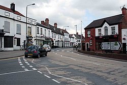 Tuxford High Street Tuxford High Street | 2,649 | Tuxford and Trent |
| Walkeringham | Civil parish |  St. Mary Magdalene Church, Walkeringham St. Mary Magdalene Church, Walkeringham | 1,022 | Beckingham |
| Wallingwells | Civil parish |  Wallingwells Hall Wallingwells Hall | 22 | Carlton |
| West Burton | Civil parish | | Unknown | Sturton |
| West Drayton | Civil parish |  West Drayton West Drayton | 225 | East Markham |
| West Markham | Civil parish |  All Saints' Church, West Markham All Saints' Church, West Markham | 170 | East Markham |
| West Stockwith | Civil parish |  West Stockwith lock West Stockwith lock | 327 | Misterton |
| Wiseton | Civil parish |  Cottages in Wiseton Cottages in Wiseton | Unknown | Clayworth |


