Ruddington is a large village in the Borough of Rushcliffe in Nottinghamshire, England. The village is 5 miles (8 km) south of Nottingham and 11 miles (18 km) northwest of Loughborough. It had a population of 6,441 at the 2001 Census, increasing to 7,216 at the 2011 Census and 7,674 in 2021. Ruddington is twinned with Grenay, France.

Dunham-on-the-Hill is a village and former civil parish, now in the parish of Dunham-on-the-Hill and Hapsford, in the unitary authority of Cheshire West and Chester, and the ceremonial county of Cheshire, England. It is on the A56 road, approximately 2.3 miles (3.7 km) from Helsby and 6 miles (9.7 km) from Chester. The village is 120 feet (37 m) above sea level, south west of Helsby Hill.
Car Colston is an English village and civil parish in the Rushcliffe borough of Nottinghamshire. The population of the civil parish at the time of the 2011 census was 185, falling to 171 at the 2021 census.

Radcliffe-on-Trent is a village and civil parish in the Rushcliffe borough of Nottinghamshire, England. The population of the civil parish at the Census 2011 was 8,205, falling slightly at the Census 2021 to 8,144

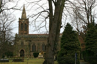
Plumtree is a village and civil parish in the borough of Rushcliffe, Nottinghamshire. At the time of the 2001 census it had a population of 221, increasing to 246 at the 2011 census, and 259 at the 2021 census. It is situated 5 miles south east of Nottingham, between the villages of Tollerton and Keyworth. Some of the farming land around the village is owned by the Duchy of Cornwall. The parish church of St Mary has a Norman tower on Saxon foundations, which were found when the tower was rebuilt in 1906. The nave is of 13th-century date. The north aisle was rebuilt and extended with stone from Nottingham's medieval Trent Bridge in 1873. Edward Hagarty Parry (1855–1931), an association footballer who captained Old Carthusians F.C. when they won the 1881 FA Cup Final against Old Etonians, is buried in the churchyard.

Rolleston is a small village and civil parish in Nottinghamshire by the River Greet, a few miles from Southwell not far from the Trent and about 5 miles (8.0 km) southwest of Newark. The population of the civil parish at the 2011 census was 312, increasing to 342 at the 2021 census. It has a church dedicated to the Holy Trinity. It lies close to the railway line between Nottingham and Lincoln with a station serving the village and Southwell as well as the nearby Southwell Racecourse.

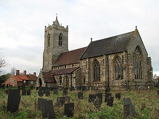
West Stockwith is a village within the Bassetlaw district of Nottinghamshire, England. The population at the 2011 census was 327, this increased to 335 at the 2021 census. It lies on the west bank of the River Trent, 3 miles (4.8 km) north-west of Gainsborough and 1.5 miles (2.4 km) east of Misterton. West Stockwith is an ecclesiastical parish in the Church of England Diocese of Southwell and Nottingham with the parish church of St Mary the Virgin's Church, West Stockwith being built in 1722.

Misterton is a village and civil parish in the Bassetlaw district of Nottinghamshire, England. The parish population at the 2011 census was 2,140, and has risen to 2,191 residents in the 2021 census.

Ragnall is a village and civil parish in Nottinghamshire, England. At the time of the 2001 census it had a population of 102, increasing to 146 at the 2011 census, and falling to 88 for the 2021 census. It is located on the A57 road one mile west of the River Trent. The parish church of St Leonard was extensively rebuilt in 1864–67. Ragnall Hall at the south end of the village is a 19th-century replacement of an early 17th-century hall, the main parts of the earlier hall surviving as barns.

Saundby is a hamlet and civil parish in Nottinghamshire two miles west of Gainsborough. Although it comes under Beckingham cum Saundby parish council, by 2011 it had become a separate civil parish in its own right. The parish is bordered on one side by the River Trent. The village Church of St Martin was extensively restored in 1885.

East Drayton is a village in Nottinghamshire, England. According to the 2001 census it had a population of 212, increasing to 252 at the 2011 Census, and 266 in 2021. It is located 3 miles west of Dunham-on-Trent. The parish church of St Peter and St Paul is 13th or 14th century in date. Nicholas Hawksmoor the architect was born here.

Shelton is an English village and civil parish in the Rushcliffe borough of Nottinghamshire. According to the 2001 census, Shelton had a population of 107,. At the 2011 census, the statistics for Shelton included Sibthorpe, and the total population was 307. For the 2021 census, Shelton alone reported 135 residents. The village lies 8 miles (13 km) south of Newark-on-Trent, on the north side of the River Smite, near where it joins the River Devon. It has no parish council, only a parish meeting.

Girton is a village and civil parish in Nottinghamshire, England. According to the 2001 census it had a population of 143, reducing slightly to 140 at the 2011 census, and 138 at the 2021 census. It is located 17 miles west of Lincoln.

Halloughton is a hamlet and civil parish in Nottinghamshire, England, 9 miles west of Newark-on-Trent. It lies in the district of Newark and Sherwood. Most of the property there was owned by the Church Commissioners until 1952. The resident population of the parish was 65 at the 2021 census.

Cromwell is a village and civil parish in Nottinghamshire, England. It is located 5 miles (8 km) north of Newark. According to the 2001 census it had a population of 188, increasing to 232 at the 2011 census, and 271 at the 2021 census.

Holme is a hamlet and civil parish in Nottinghamshire, England. The population of the civil parish at the 2011 census was 165, Holme alone registered 80 residents at the 2021 census. It is within the district of Newark and Sherwood, on the east of the River Trent, less than half a mile from the riverside and 4 miles north of Newark-on-Trent.

Normanton on Trent is a village in Nottinghamshire, England. It is nine miles south-east of Retford.

Newton on Trent is a village and civil parish in the West Lindsey district of Lincolnshire, England. The population of the civil parish at the 2011 census was 389. The village is situated east of the River Trent, and is 10 miles (16 km) south of Gainsborough, 10 miles (16 km) west of Lincoln, and at the junction of the A57 running east to west, and the A1133 running north to south.

South Muskham is a village and civil parish in Nottinghamshire, England, close to the border with Lincolnshire. It is located west of the River Trent and the A1 road, 2 miles (3 km) north of Newark-upon-Trent. The parish includes the hamlet of Little Carlton. The population of the parish was 494 in the 2011 census, falling to 469 at the 2021 census.
Dunham-on-Trent is a civil parish in the Bassetlaw District of Nottinghamshire, England. The parish contains eleven listed buildings that are recorded in the National Heritage List for England. Of these, one is listed at Grade I, the highest of the three grades, and the others are at Grade II, the lowest grade. The parish contains the village of Dunham-on-Trent and the surrounding area. The listed buildings consist of houses and cottages, farmhouses and farm buildings, a church and items in the churchyard, a public house and a war memorial.


