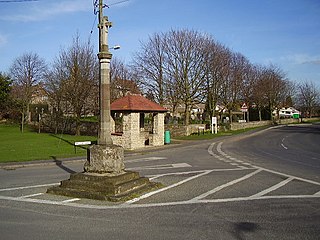
Cranwell is a village in the civil parish of Cranwell, Brauncewell and Byard's Leap, in the North Kesteven district of Lincolnshire, England. It is situated approximately 3 miles (5 km) north-west from Sleaford and 14 miles (23 km) south-east from Lincoln. The principal through road, the B1429 between the A15 to the east and the A17 to the west, joins the village to RAF Cranwell. The appropriate civil parish is called Cranwell, Brauncewell and Byard's Leap with a population of 2,827 at the 2011 census.

Finningley is a village and civil parish in the City of Doncaster, South Yorkshire, England. Historically in Nottinghamshire, it lies on the A614 road between Bawtry and Thorne, about 6 miles south-east of Doncaster. In the 2011 census, it had a population of 1,497. The Finningley ward of Doncaster Metropolitan Borough Council covers 16.8 square miles, including the villages of Auckley, Branton, Blaxton, Hayfield and Bessacarr Grange, and part of Cantley.

Lakenheath is a village and civil parish in the West Suffolk district of Suffolk in eastern England. It has a population of 4,691 according to the 2011 Census, and is situated close to the county boundaries of both Norfolk and Cambridgeshire, and at the meeting point of The Fens and the Breckland natural environments.

The Tri-National Tornado Training Establishment (TTTE) was a multinational air unit based at RAF Cottesmore in Rutland, England, from 1981 to 1999. It performed training on the Panavia Tornado for the Royal Air Force (RAF), Luftwaffe, Marineflieger and Italian Air Force. Initially, pilots received four weeks of training on the ground, followed by nine weeks in the air.
Fowlmere is one of the southernmost villages in Cambridgeshire, England. The population of the civil parish at the 2011 Census was 1,206. It is very close to the Imperial War Museum Duxford, and 9 miles (14 km) southwest of the city of Cambridge.

Thorney is a village in the Peterborough unitary authority in the ceremonial county of Cambridgeshire, England. Located around eight miles (13 km) east of Peterborough city centre, on the A47.
Auckley is a village and civil parish in the City of Doncaster in South Yorkshire, England, about five miles east of Doncaster city centre. According to the 2011 census the parish had a population of 3,745, increasing to 4,962 at the 2021 Census. The parish includes the areas of Auckley and Hayfield Green.

Wretham is a civil parish in the Breckland district of Norfolk, England. The parish includes the village of East Wretham, which is about 6 miles (10 km) northeast of Thetford and 25 miles (40 km) southwest of Norwich. It also includes the villages of Illington and Stonebridge. The parish has an area of 32.25 km2 (12.45 sq mi). The 2011 Census recorded a parish population of 374 people in 141 households.

Winthorpe is a village and civil parish located 2 miles (3 km) northeast of Newark-on-Trent in Nottinghamshire, England. The population at the 2011 census was 650, falling to 595 at the 2021 census. The name is probably from old English wynne þrop (thorp), which translates as 'hamlet of joy'. An alternative etymology is Wigmund 's or Vigmund 's village.

Farnsfield is a large village and civil parish in Nottinghamshire in Sherwood Forest. It is in the local government district of Newark and Sherwood. The population of the civil parish as at the United Kingdom Census 2001 was 2,681, increasing in the 2011 census to 2,731, and 3,216 at the 2021 census.
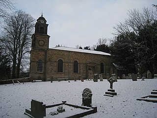
Ossington is a village and civil parish in the county of Nottinghamshire, England 7 miles north of Newark-on-Trent. The population count was 109 residents at the 2021 census. It was centred on Ossington Hall, the ancestral home of the Denison family, but the house was demolished in 1964 and all that remains are a few outbuildings and a private chapel that now serves the parish as Holy Rood Church, Ossington. This is a Grade I listed building, originally 12th century and rebuilt in 1782–1783 by the architect John Carr, with minor 19th-century alterations and additions. It includes earlier monuments and stained glass. There is a barrel organ built by Thomas Robson in 1840.

Kneesall is a village and civil parish in the East Midlands of England in the county of Nottinghamshire. The population of the civil parish at the 2011 census was 221, increasing slightly to 227 at the 2021 census. Forming part of the Newark and Sherwood district, Kneesall is situated on the A616 road between Newark-on-Trent and Ollerton. The village is three miles from neighbouring Eakring and four miles from Laxton.

Lound is a village in Nottinghamshire, England, four miles north of Retford. It had a population of 493 in the census of 2001, reducing to 471 at the 2011 census, and 454 in 2021. The village is of Danish origin dating from the 8th century with a street running along the spine of the village, leading on to Lound Low Road. The oldest houses are tofts which are endways on to the street with strips of land running back from the road. Nearby villages are Sutton cum Lound and Mattersey.

Coddington is a village and civil parish in the Newark and Sherwood district of Nottinghamshire, England. It is 3 miles (4.8 km) east of Newark-on-Trent. According to the 2001 census it had a population of 972, which increased to 1,684 at the 2011 Census and to 1,538 at the 2021 census.

Misson is a village and civil parish in Nottinghamshire, England. It is located 12 miles north of Retford, and not directly accessible from the rest of Nottinghamshire, as it is on the north bank of the River Idle. Misson Springs, which lie north of the village itself, is the northernmost place within the county. The parish also includes the hamlet of Newington, at its western edge. According to the 2001 census it had a population of 698, increasing to 711 at the 2011 census, and marginally more to 713 residents at the 2021 census.

Woodborough is a village and civil parish in the Gedling district, in the county of Nottinghamshire, England. It is located 7 miles (11 km) north-east of Nottingham. According to the 2001 census it had a population of 1,852, rising slightly to 1,872 at the 2011 census, and 1,909 at the 2021 census.

Wigsley is a village and civil parish in Nottinghamshire, England. The population of the civil parish taken at the 2011 census was 178, Wigsley alone reported 118 residents in the 2021 census. It is located 10 miles west of Lincoln. To the south-west of the village are the remains of R.A.F. Wigsley airfield. Wigsley is one of the Thankful Villages – those rare places that were spared fatalities in the Great War of 1914 to 1918.

Gamston is a village and civil parish four miles south of Retford in the English county of Nottinghamshire. The village lies on the A638 road between Retford and the Markham Moor junction with the A1 and the A57 roads. The population of the civil parish as at the 2011 Census was 246, which increased to 253 in 2021. The River Idle lies to the west of the village.

Tadmarton is a village and civil parish about 4 miles (6.4 km) west of Banbury, Oxfordshire. The 2011 Census recorded the parish's population as 541, which is a 26% increase on the figure of 430 recorded by the 2001 Census.

Mattersey Thorpe is a small village in the Bassetlaw district of northern Nottinghamshire, England. It is 134 miles (216 km) north of London, 32 miles (51 km) north of the county town and city of Nottingham, and 5+1⁄2 miles (8.9 km) north of the town of Retford. It is in the civil parish of Mattersey.


