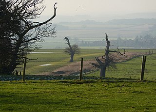
Grove is a small village and civil parish, located about 2 miles (3.2km) south-west of Retford, Nottinghamshire. The population of the civil parish as of the 2011 census is 105,[1] increasing to 127 in 2021.[2] The parklands of Grove Hall separate it from Retford town, and a set of gates for Grove Hall can be found near the London Road, the A638.
The village itself is pleasant with wide verges along parts of the main road. The village once contained a garden centre, now built on, housed in the former kitchen gardens, of the Hall and there is also a very fine parish church.
History
The barony of Grove, with the manor of West Retford was part of the large property granted by William the Conqueror to Roger de Busli and is thus noted in Domesday survey, as "Grave".
From Roger de Busli it came to Gerbert (or Gilbert) de Arches, Baron de Grove, in the early part of the reign of Henry II. Gilbrt's great granddaughter, Theophania, being a co-heiress, carried it to Malvesinus de Hercy, in the reign of Henry III. It continued in the Hercy family till Sir John de Hercy bequeathed it to Barbara, one of his sisters, and co-heiress, who had married George Nevile of Ragnall, in whose family it continued till the latter end of the seventeenth century, when Sir Edward Nevile sold it to Sir Creswell Levinz, one of the Judges of the Common Pleas.
Sir Creswell Levinz was succeeded by his son, William Levinz, who resided at Grove and was MP for East Retford and afterwards for Nottinghamshire. This William Levinz left a son, William, who alienated the greatest part of his inheritance and sold the manor and estate of Grove, with its appurtenances in the year 1762, to Anthony Eyre of Rampton and Adwick.
Grove Hall, a large brick house in the old English style, with gable ends and mullion windows, had been erected at Grove, at a period which is not known, and had undergone considerable alterations.
During the wars between the Houses of York and Lancaster, the Hercy family, with their neighbours the Stanhopes, of Rampton, were active supporters of the House of Lancaster, and during the arduous struggle for superiority, were frequently surrounded by dangers of no common kind; till at length Victory
"To Tudor's brow transferred the gem, The long disputed diadem."
Of our forefathers great in deeds of arms! To late posterity memorial stand
Of their immortal fame."
A track in Castle Hill Wood
Within the precincts of the parish, is a wood generally designated "Castle Hill Wood" where, as its name suggests, has formerly stood a castle on a mount (or Mote), which appears to have been surrounded by a double trench of considerable magnitude, having the entrance to the south-east. To the south-east of this mount is a piece of ground, now almost level, where the traces of foundations are discernible; this is surrounded by a moat both wide and deep having formerly circumscribed a mansion or castle, but of which no definite remains are now in existence. This place, as well as the one just alluded to, together with the greatest part of an extensive wood, are still circumvallated, and a trench or foss, in some instances double, may be distinctly traced for upwards of a mile.
It is generally acknowledged that this part of the country formed a portion of the settlements of the Coritani, but that in common with the rest of Great Britain, it became a prey to the Roman armies, who, in making the conquest, were necessitated to undergo considerable hardships and privations, and on obtaining possession, to cast up those fortresses and bulwarks, which, in almost every part of the United Kingdom, remain to the present time, as mementos of their bravery and determined perseverance.
It is believed it "may be properly attributed the formation of these extensive works, although others have supposed them to have been originally British".[citation needed] But opinion with respects to this site, are "other circumstances concurring with the above, tending to confirm the supposition of their being of Roman origin".[citation needed] About a mile beyond Little Gringley are the traces of an encampment to the right of the road leading to Leverton; "which road has every appearance of having been Roman, and was continued to North Leverton onward to the Roman station at Littleborough, without fetching the compass towards South Leverton, which it now does; and the old road may still be traced, being, with the intervention of a wood, nearly entire".[citation needed]
The situation is particularly noted in some of the oldest maps of Nottinghamshire, under the appellation of 'Little Gringley Castle."
"This place has occupied the attention of antiquarians for a long period, in attempting to fix upon it as the Segelocum, mentioned in the Itenerary of Antoninus. Camden, in his first edition of the Britannia, had fixed this station at Eaton, but afterwards, it is said, he changed his opinion in favour of Littleborough. Mr. Horsley, also decidedly says "Segelocum or Agelocum, as called in two iters, is certainly Littleborough. Dr. Gale was of the same opinion; and Pegge, in his British Topography, seems to coincide therewith. To such an host of observations and conjectures, I cannot presume to add any thing, save that of recording an humble opinion in favour of that given by Mr. Horsley.
In 1684, when the inclosures between the bridge and town were first ploughed up, many coins of Nerva, Trajan, Hadrian, Constantine, &c. were found, together with intaglios of agate, and cornelian, the finest coloured urns, and paterae, some wrought in basso relievo, with the workman's name generally impressed on the inside of the bottom; also a discus, or quoit, with an emperor's head embossed upon it. Again, in 1718, two very handsomely moulded altars were dug up, and in 1759, the drawing of another was communicated to the Society of Antiquaries. A curious tassera, or tally, was also found near this place; these tallies were supposed to have been used in the Roman armies, to distinguish each other from the enemy, and for setting the nightly watch."[citation needed]
On this road, between Leverton and Littleborough, formerly existed a stone bridge, about the repairs of which, several disputes arose. In 1253, the court of Oswardbeck was held at Sturton, when an inquisition was taken, as to whether the inhabitants of Sturton and Fenton, or the abbot of Welbeck should repair it; the jurors gave it in favour of the abbot.
Bassetlaw was a wapentake in the English county of Nottinghamshire. The wapentake covered an area in the north of the county, roughly equivalent to the modern Bassetlaw local government district. The wapentake was divided into the divisions of Hatfield, North Clay and South Clay.
South Leverton is a village and civil parish in Bassetlaw, north Nottinghamshire, England, four miles from Retford. According to the 2001 census it has a population of 478, increasing marginally to 480 at the 2011 census, and more substantially to 514 at the 2021 census.
Cottam is a village and civil parish in Nottinghamshire 8 miles east of Retford within the Bassetlaw district. The name is pronounced 'Cotum' locally.
Littleborough is a village and former civil parish, now in the parish of Sturton le Steeple, in the Bassetlaw district, in the county of Nottinghamshire, England. It is 8 miles (13 km) east of Retford. Littleborough is the site of the Roman town of Segelocum or Agelocum, on the west bank of the River Trent where the road linking Lincoln and Doncaster bridged or forded the river. In 1931 the parish had a population of 32. On 1 April 1935 the parish was abolished and merged with Sturton le Steeple.
Sturton le Steeple is a village located 6 miles (9.7 km) east of Retford, Nottinghamshire, England. According to the 2001 census it had a population of 497, reducing slightly to 486 at the 2011 census, but increasing to 545 residents in the 2021 census.
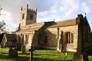
St. Helen's Church, Grove is a parish church in the Church of England in Grove, Nottinghamshire.
Grove Hall was an extended Tudor country house located between Retford and Grove in Nottinghamshire, England, and was part of an extensive estate.
The A1500 is an 'A' road entirely within the English county of Lincolnshire. It links the A156 at Marton with the A15 south of RAF Scampton via Sturton by Stow.
All Saints' Church, is a Grade I listed parish church in the Church of England in Babworth, Nottinghamshire.
St Peter's Church, Gamston is a Grade I listed parish church in the Church of England in Gamston, Bassetlaw.
Anthony Eyre was a British landowner and politician who sat in the House of Commons between 1774 and 1784.
William Levinz of Grove Hall and Bilby, Nottinghamshire was a British lawyer and Tory politician who sat in the English and British House of Commons between 1702 and 1734. He fought a duel with an opposing Whig agent.
Headon cum Upton is a civil parish in the Bassetlaw district, in the county of Nottinghamshire, England. The parish includes the villages of Headon, Upton and the hamlet of Nether Headon. The parish is adjacent to Askham, Gamston, East Drayton, Eaton, Grove, Rampton and Woodbeck, Stokeham and Treswell. In the 2021 census, the parish had a population of 192. The area is 3.5 miles south east of the nearest market town Retford, 26 miles north east of the county town Nottingham and 125 miles north of London. Headon cum Upton shares a parish council with Grove and Stokeham. There are 6 listed buildings in Headon cum Upton.
South Wheatley is a village and former civil parish, now within the North and South Wheatley civil parish, of Bassetlaw district, in the county of Nottinghamshire, England. In 2001 South Wheatley parish had a population of 102. It is 130 miles north of London, 30 miles north east of the county town of Nottingham, and 5 miles north east of the Nottinghamshire town of Retford. There are 4 listed buildings in South Wheatley.
Clarborough and Welham is a civil parish in the Bassetlaw district, in the county of Nottinghamshire, England. The parish includes the village of Clarborough and the hamlet of Welham. In 2021 the parish had a population of 1,041. It is 130 miles north of London, 28 miles north east of the city of Nottingham, and 2 miles north east of the market town of Retford. The parish touches Hayton, North and South Wheatley, North Leverton with Habblesthorpe and Sturton Le Steeple. There are 14 listed buildings in Clarborough and Welham.
North and South Wheatley is a civil parish in the Bassetlaw district, in the county of Nottinghamshire, England. The parish includes the villages of North Wheatley and South Wheatley. In 2021 the parish had a population of 610 residents. It is 130 miles north of London, 30 miles north east of the county town of Nottingham, and 5 miles north east of the Nottinghamshire town of Retford. The parish touches Bole, Clarborough and Welham, Clayworth, Hayton, Saundby, Sturton Le Steeple and West Burton. There are 18 listed buildings in North and South Wheatley.
Little Gringley is a hamlet in the Bassetlaw district of northern Nottinghamshire, England. It is 130 miles (210 km) north of London, 27 miles (43 km) north east of the county town and city of Nottingham, and 1+3⁄4 miles (2.8 km) east of the nearest town Retford.
Edward Neville (1651–85) was the member of parliament for Retford during the Exclusion Parliament. He represented the borough from 1679–81 and from 1685-6.
This page is based on this Wikipedia article Text is available under the CC BY-SA 4.0 license; additional terms may apply. Images, videos and audio are available under their respective licenses.