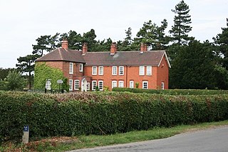
Grove Hall was an extended Tudor country house located between Retford and Grove in Nottinghamshire, England, and was part of an extensive estate.
Contents

Grove Hall was an extended Tudor country house located between Retford and Grove in Nottinghamshire, England, and was part of an extensive estate.

The barony of Grove, with the manor of West Retford, was part of the large property granted by William the Conqueror to Roger de Busli. It was noted in Doomsday survey as "Grave". From Roger de Busli it came to Gerbert (or Gilbert) de Arches, Baron de Grove, in the early part of the reign of Henry II. Gilbert's great granddaughter, Theophania, being a co-heiress, carried it to Malvesinus de Hercy in the reign of Henry III.
The Hercy family built the original wing of Grove Hall. The estate continued in the Hercy family till Sir John de Hercy died in 1570 with no children but with eight sisters. Grove Hall was bequeathed to one of the sisters, Barbara, who had married George Nevile of Ragnall.
It descended in the Nevile family until the latter end of the seventeenth century, when Sir Edward Nevile sold it to Sir Creswell Levinz, one of the Judges of the Common Pleas.
Sir Creswell Levinz was succeeded by his son, William Levinz, who resided at Grove and was High Sheriff of Nottinghamshire for 1707–08 and sometime MP for East Retford and afterwards for Nottinghamshire. This William Levinz left a son, William, who alienated the greatest part of his inheritance and in 1762 sold the manor and estate of Grove, with its appurtenances, to Anthony Eyre of Rampton and Adwick-le-Street.
Anthony Eyre's son, Anthony Hardolph Eyre, died in 1836 leaving two daughters, one of which, Frances, inherited Grove. She had married Granville Harcourt Vernon, son of the Archbishop of York. The property passed down in the Harcourt-Vernon family to Granville Charles FitzHerbert Harcourt-Vernon, who sold the house in 1946. [1]
The buyer was a Canon R.F. Wilkinson, who quickly sold it again, it was then used by the Ministry of Health for a short period, before being demolished by 1952. The site of the hall itself now contains a number of steel and concrete agricultural buildings (as part of a poultry farm) of little historic or architectural significance. [2]
Remaining features of note throughout the estate include: [3]

A large brick house in the Old English style, with gable ends and mullion windows, had been erected at Grove at a period which is not known, and had since undergone considerable alterations. During the wars between the Houses of York and Lancaster, the Hercy family, with their neighbours the Stanhopes, of Rampton, were active supporters of the House of Lancaster, and during the arduous struggle for superiority were frequently surrounded by dangers of no common kind; till at length Victory
"To Tudor's brow transfer'd the gem, The long disputed diadem."
Afterwards, as a mark of their zeal, and as a remembrance of their past services, they each of them inserted in the walls of their respective mansions, a sculptured rose and crown, the device assumed by Henry VII and by many of his adherents. At Grove this device was placed in the house over a large Gothic window which lights the principal staircase.
Sir Creswell Levinz and his son made some alterations in the house, as did Anthony Eyre after he purchased it, entirely altering the character of it. He removed the whole of the ancient roof and pulled down a considerable part of the south-west front, in the place of which, under the direction of architect John Carr, he built a suite of rooms of more convenient dimensions. In making this alteration, he took down a stone tower, which must have been built in the time of Queen Elizabeth I, under which were found a considerable number of the coins of that Queen's reign.
The lordship of Grove was extensive, containing about 1,500 acres (6.1 km2), part of which is covered with wood, and the rest is occupied, either in grazing, or to agricultural purposes.
The situation of Grove Hall, is said to be the most elevated and picturesque in the Nottinghamshire; on all sides, the views are pleasing and extensive: to the east the levels of Lincolnshire appear "beautifully tinted with variety, the view of which, is backed with the noble promontory on which part of the city of Lincoln stands, whilst the minster rears its venerable head, and overlooks the vast Plains which extend themselves until the ocean terminates their bounds". To the west the view is equally extensive, the ancient forest of Sherwood, "from the numerous woods and plantations which rear their heads in every direction, reminds the beholder of ancient days, when the famous oaks displayed their towering boughs; this very interesting view is only terminated by the hills of Kinderskout in Derbyshire".
Babworth is a village and civil parish in the Bassetlaw district of Nottinghamshire, England, about 2 miles west of Retford. According to the 2001 census the parish had a population of 1,329, rising to 1,687 at the 2011 Census, but dropping to 1,489 in 2021. In addition to the village of Babworth, the parish also includes Ranby.

This is a list of the High Sheriffs of the English county of Nottinghamshire.

Grove is a small village and civil parish, located about 2 miles (3.2 km) south-west of Retford, Nottinghamshire. The population of the civil parish as of the 2011 census is 105, increasing to 127 in 2021. The parklands of Grove Hall separate it from Retford town, and a set of gates for Grove Hall can be found near the London Road, the A638.
The Sheriff of Nottinghamshire, Derbyshire and the Royal Forests is a position established by the Normans in England.

St. Helen's Church, Grove is a parish church in the Church of England in Grove, Nottinghamshire.
Granville Harcourt-Vernon, was a British politician.

Sir Gervase Clifton, 1st Baronet, K.B. was an English politician who sat in the House of Commons at various times between 1614 and 1666. He supported the Royalist cause in the English Civil War. He was educated at St John's College, Cambridge.
The Venerable John Eyre was Archdeacon of Nottingham
Anthony Eyre was a British landowner and politician who sat in the House of Commons between 1774 and 1784.
Anthony Eyre JP was an English politician who sat in the House of Commons from 1661 to 1671.
William Levinz of Grove Hall and Bilby, Nottinghamshire was a British lawyer and Tory politician who sat in the English and British House of Commons between 1702 and 1734. He fought a duel with an opposing Whig agent.

Headon cum Upton is a civil parish in the Bassetlaw district, in the county of Nottinghamshire, England. The parish includes the villages of Headon, Upton and the hamlet of Nether Headon. The parish is adjacent to Askham, Gamston, East Drayton, Eaton, Grove, Rampton and Woodbeck, Stokeham and Treswell. In the 2021 census, the parish had a population of 192. The area is 3.5 miles south east of the nearest market town Retford, 26 miles north east of the county town Nottingham and 125 miles north of London. Headon cum Upton shares a parish council with Grove and Stokeham. There are 6 listed buildings in Headon cum Upton.

Headon is a village in Headon cum Upton civil parish, in the Bassetlaw district, of the county of Nottinghamshire, England. The village is adjacent to the villages of Upton, Nether Headon, East Drayton, Eaton, Gamston, Woodbeck and Stokeham. In 2011 the parish, together with Stokeham had a population of 253. The area is 3.5 miles south east of the nearest market town Retford, 26 miles north east of the county town Nottingham and 125 miles north of London. There are 2 listed buildings in Headon village.

Nether Headon is a hamlet in Headon cum Upton civil parish, within the Bassetlaw district, of the county of Nottinghamshire, England. It is 3.5 miles south east of the nearest market town Retford, 26 miles north east of the county town Nottingham and 125 miles north of London. The hamlet is adjacent to the villages of Upton, Headon, East Drayton, Eaton, Grove, Woodbeck and Stokeham. In 2011 the parish, together with Stokeham had a population of 253.

Little Gringley is a hamlet in the Bassetlaw district of northern Nottinghamshire, England. It is 130 miles (210 km) north of London, 27 miles (43 km) north east of the county town and city of Nottingham, and 1+3⁄4 miles (2.8 km) east of the nearest town Retford.
Edward Neville (1651–1685) was the member of parliament for Retford during the Exclusion Parliament. He represented the borough from 1679–81 and from 1685-6.
Anthony Eyre was an English landowner who served as High Sheriff of Nottinghamshire.
Anthony Hardolph Eyre JP was a British landowner and politician who sat in the House of Commons.
Sir Hardolph Wasteneys, 4th Baronet JP DL was an English landowner who sat in the House of Commons for East Retford.
Sir Henry Cooke, 2nd Baronet was an English landowner.
This duplicates public domain text from Piercy, John S. (1828). The History of Retford.