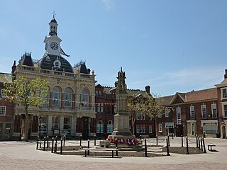
Retford, also known as East Retford, is a market town in the Bassetlaw District in Nottinghamshire, England, and one of the oldest English market towns having been granted its first charter in 1105. It lies on the River Idle and the Chesterfield Canal passes through its centre. Retford is 26 miles (42 km) east of Sheffield, 23 miles (37 km) west of Lincoln and 31 miles (50 km) north-east of Nottingham. The population at the 2011 census was 22,013.

Ollerton is a town in the Newark and Sherwood District, Nottinghamshire, England, on the edge of Sherwood Forest in the area known as the Dukeries. It forms part of the civil parish of Ollerton and Boughton. The population of this civil parish at the 2011 census was 9,840.
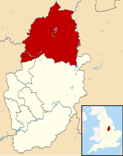
Bassetlaw is a local government district in Nottinghamshire, England. The district has four towns: Worksop, Tuxford, Harworth Bircotes and Retford. It is bounded to the north by the Metropolitan Boroughs of Doncaster and Rotherham, the east by West Lindsey, the west by both the Borough of Chesterfield and North East Derbyshire and the south by Mansfield District and Newark and Sherwood. The district is along with Bolsover District, North East Derbyshire and Borough of Chesterfield is a non-constituent member of the Sheffield City Region.

Bassetlaw is a parliamentary constituency in Nottinghamshire, represented in the House of Commons of the UK Parliament since the 2019 general election by Brendan Clarke-Smith, a Conservative. Before that election, the seat had been part of the so-called "red wall", being held by the Labour Party since 1929.
East Markham, historically also known as Great Markham, is a small village and civil parish near Tuxford, Nottinghamshire. The population of the civil parish taken at the 2011 Census was 1,160. It lies about 8 km south of Retford. It is sandwiched between the East Coast Main Line, the A1 to the west and A57 to the north.

Worksop was a Rural District in Nottinghamshire, England.

Tuxford is a historic market town and a civil parish in the Bassetlaw district of Nottinghamshire, England. At the 2001 census, it had a population of 2,516, increasing to 2,649 at the 2011 census.

North Wheatley is a village and former civil parish, now in the parish of North and South Wheatley, in Bassetlaw district, in the county of Nottinghamshire, England. At the time of the 2001 census it had a population of 489, increasing to 509 at the 2011 census. It is located 6 miles north-east of Retford. The village has a number of 17th century brick houses. The Old Hall on Low Street/Church Hill is dated 1673, with the arms of the Cartwright family. The parish church of St Peter and St Paul was restored in 1896. Many farms in the area have dovecotes, either as free-standing buildings or above farm buildings. The civil parish was merged with South Wheatley to form North and South Wheatley.
Markham Moor is a village which lies five miles south of the town of Retford in Nottinghamshire. The village is in the civil parish of West Drayton. Markham Moor lies on the junction between the A1, A638 and A57 roads. The village was on the route of the old Great North Road and was also traditionally part of the East Markham parish.

Our Lady and St Peter's Church, Bothamsall is a Grade II listed parish church in the Church of England in Bothamsall. The church is part of the Lound Hall Estate, Bothamsall. The buildings repair costs are procured by the Lord of the manor.

St Peter's Church, Gamston is a Grade I listed parish church in the Church of England in Gamston, Bassetlaw.

All Hallows’ Church is a Grade II* listed parish church in the Church of England in Ordsall, Nottinghamshire.

St Paul's Church is a Grade II* listed parish church in the Church of England in West Drayton, Nottinghamshire.

All Saints’ Church, South Leverton is a Grade II* listed parish church in the Church of England in South Leverton, Nottinghamshire.

St Michael the Archangel's Church is a Grade II* listed parish church in the Church of England in Retford, Nottinghamshire, England.

Little Gringley is a hamlet in the Bassetlaw district of northern Nottinghamshire, England. It is 130 miles (210 km) north of London, 27 miles (43 km) north east of the county town and city of Nottingham, and 1+3⁄4 miles (2.8 km) east of the nearest town Retford.
