Hodsock

Last updated

Hodsock
Civil parish
Hodsock Priory - geograph.org.uk - 796273.jpg
Hodsock
Parish map
Nottinghamshire UK location map.svg
Red pog.svg
Hodsock
Location within Nottinghamshire
Area16.5 km2 (6.4 sq mi)
Population2,603 (2021) [1]
  Density 158/km2 (410/sq mi)
OS grid reference SK587872
  London 130 mi (210 km)  SE
District
Shire county
Region
Country England
Sovereign state United Kingdom
Settlements
Post town WORKSOP
Postcode district S81
Dialling code 01909
UK Parliament
Website www.hodsockparishcouncil.org.uk
List of places
UK
England
Nottinghamshire
53°21′40″N1°04′54″W / 53.361°N 1.0816°W / 53.361; -1.0816

Hodsock is a village and civil parish about 4 miles from Worksop, in the Bassetlaw district, in the county of Nottinghamshire, England. The parish includes the village of Langold [2] and the country house Hodsock Priory. [3] In 2021 the parish had a population of 2,603. [1] [4] The parish is surrounded by the settlements of Babworth, Barnby Moor, Blyth, Carlton in Lindrick, Costhorpe, Firbeck, Letwell, Maltby, Styrrup with Oldcotes and Torworth. [5]

Contents

Toponymy

The name "Hodsock" means 'Hod's oak-tree'. [6]

Geography

The area is 4 miles north east of Worksop, and 30 miles north of Nottingham.

The parish consists of two settlements:

A deserted village, Hermeston possibly existed locally, but the exact location remains unknown.

The border by Langold is shared with the county of South Yorkshire and Rotherham borough.

Three classified routes pass through the area:

Predominantly, the parish is a scattering of farms, farmhouses and cottages amongst a wider rural setting. The area around Langold is more built up in character. The River Ryton forms part of the east border of the parish, the Oldcotes Dyke is the northern border and drains into the Ryton.

Forested areas are mainly to the south of Hodsock, but some surround Langold including Langold Country Park.

The parish is very low-lying, averaging 20 metres (66 ft), with the highest points just north of Langold at 52 metres (171 ft) and by the B6045 road with the southern parish boundary at 48–50 metres (157–164 ft).

Communities

Hodsock village

The historic centre of the area is Hodsock Priory, which is an landed country house and estate. Despite its name, it is not and never has been a priory. Hodsock was recorded in the Domesday Book as Odesach. [7] Hodsock was formerly a lordship in the parish of Blyth, [8] in 1866 Hodsock became a civil parish in its own right. [9] The Priory and gardens is at the centre of the 800-acre (3.2 km2) estate, owned by the Mellish and Buchanan families since 1765. [10] The farm is 700 acres (2.8 km2) and grows carrots, wheat, barley and sugar beet. There is 100 acres (0.40 km2) of managed woodland.

Langold

Langold village was built to provide housing for the miners of Firbeck Colliery. Before the early twentieth century it consisted of farmland and parkland in the estates of Firbeck and Hodsock. Hodsock Priory and estate with its farms, and much of Carlton-in-Lindrick were bought by the Mellish family in 1765, parts of which they sold on to Ralph Knight of Langold. Much of what was Knight's Langold estate remains within South Yorkshire presently. By 1911, mining in the area suggested that there may be a workable seam of coal at Langold. The Wallingwells Boring Company was created, but the First World War brought a stop to the work. Sinking of the first colliery shaft began in 1923. Construction of housing began to the west of the main road in 1924, and completed in 1927. The mine closed on 31 December 1968.

Hermeston

The parish possibly included the deserted medieval village of Hermeston. Though its location is not known nor is it known if it was one, [11] it was referred to in historical texts, [12] and was likely to be close to (and possibly north of) present day Hermeston Hall.

Governance

Hodsock Parish Council administer the first layer of public services.

Bassetlaw District Council administer the next tier of services, with Nottinghamshire County Council actioning the highest level of local public duties.

Landmarks

There are 13 listed buildings in Hodsock, [13] including the Priory and Langold War Memorial.

Related Research Articles

<span class="mw-page-title-main">Blyth, Nottinghamshire</span> Village and civil parish in England

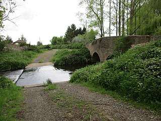
Blyth is a village and civil parish in the Bassetlaw district of the county of Nottinghamshire, in the East Midlands, north west of East Retford, on the River Ryton. The population of the civil parish as of the 2011 census was 1,233, and this increased to 1,265 in 2021. It sits at a junction with the A1, and the end of the motorway section from Doncaster.

<span class="mw-page-title-main">Firbeck</span> Village and civil parish in South Yorkshire, England

Firbeck is a village and civil parish in the Metropolitan Borough of Rotherham in South Yorkshire, England, on the border with Nottinghamshire. It lies between Maltby and Oldcotes, off the A634 and B6463 roads. Firbeck had a population of 317 in 2001, which had fallen to 299 at the 2011 Census.

<span class="mw-page-title-main">River Ryton</span> River in Nottinghamshire, England

The River Ryton is a tributary of the River Idle. It rises close to the Chesterfield Canal near Kiveton Park, and is joined by a series of tributaries near Lindrick Common in the Metropolitan Borough of Rotherham, South Yorkshire, England. Most of its course is in Nottinghamshire, flowing through the town of Worksop. It meanders northwards to join the River Idle near the town of Bawtry on the South Yorkshire-Nottinghamshire border.

<span class="mw-page-title-main">Bassetlaw (UK Parliament constituency)</span> Parliamentary constituency in the United Kingdom, 1885 onwards

Bassetlaw is a parliamentary constituency in Nottinghamshire, represented in the House of Commons of the UK Parliament since the 2019 general election by Brendan Clarke-Smith, a Conservative. Before that election, the seat had been part of the so-called "red wall", being held by the Labour Party since 1929.

<span class="mw-page-title-main">Barnby Moor</span> Civil parish in England

Barnby Moor is a village and civil parish in the Bassetlaw district of Nottinghamshire, England, with a population of 257, increasing to the 2011 Census to 278, and dropping marginally to 274 in 2021. The village is about three miles north of Retford.

<span class="mw-page-title-main">Bassetlaw Wapentake</span>

Bassetlaw was a wapentake in the English county of Nottinghamshire. The wapentake covered an area in the north of the county, roughly equivalent to the modern Bassetlaw local government district. The wapentake was divided into the divisions of Hatfield, North Clay and South Clay.

Oldcotes is a village in Nottinghamshire, England. It is in the civil parish of Styrrup with Oldcotes. The village is centred on the crossroads of the A60 and A634 roads, five miles south east of Maltby.

<span class="mw-page-title-main">Harworth Colliery</span> Coal mine in Nottinghamshire, England

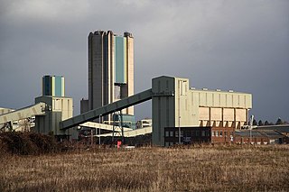
Harworth Colliery was a colliery near the town of Harworth Bircotes in Bassetlaw, Nottinghamshire, England.

<span class="mw-page-title-main">Hodsock Priory</span> Grade II listed country house in Nottinghamshire, United Kingdom

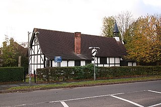
Hodsock Priory is an English country house in Hodsock, Nottinghamshire, 4 miles (6.4 km) north of Worksop, England, and 1 mile (1.6 km) south of Blyth. Despite its name, it is not and never has been a priory. Hodsock is renowned for its snowdrops in early spring. It is also a venue for special events and weddings.

<span class="mw-page-title-main">Langold</span> Human settlement in England

Langold is a village in the civil parish of Hodsock, in the Bassetlaw district, north Nottinghamshire, England. At the 2011 census it was defined as a ward of Bassetlaw Council with a population of 2,472. It was built to provide housing for the miners of Firbeck Colliery between 1923 and 1927. Langold Lakes Country Park is situated on the south-western edge of the village.

<span class="mw-page-title-main">Carlton in Lindrick</span> Village in north Nottinghamshire, England

Carlton in Lindrick is a village and civil parish about 3 miles (5 km) north of Worksop in Nottinghamshire, England. The 2011 Census recorded a parish population of 5,623, including nearby Wallingwells. The 2021 Census reported alone on Carlton in Lindrick, with 5,635 residents.

<span class="mw-page-title-main">Hermeston Hall</span>

Hermeston Hall is a manor house near to the villages of Oldcotes and Langold, and within the parish or Hodsock, northwestern Nottinghamshire, England. It is located in a lane just off the A60 road, just south of the village of Oldcotes on the road to Langold.

<span class="mw-page-title-main">Styrrup</span> Human settlement in England

Styrrup is a village in the civil parish of Styrrup with Oldcotes on the B6463 road in the Bassetlaw district, in the English county of Nottinghamshire. The population of the civil parish at the 2021 census was 731, an increase from the 685 of 2011. It is near the small town of Harworth. The village is surrounded by farmland and is approximately 1 mile from the A1 road intersection at Blyth. The housing consists primarily of modern properties constructed in the 1970s and numerous barn conversions arranged off the Main Street. The local pub, The White Swan, has been demolished and replaced by modern housing.

<span class="mw-page-title-main">St John the Evangelist's Church, Carlton in Lindrick</span> Parish church of Carlton in Lindrick, Nottinghamshire, England

St John the Evangelist's Church is a Grade I listed parish church in the Church of England in Carlton in Lindrick, Nottinghamshire.

<span class="mw-page-title-main">Oldcotes Dyke</span> River in England

Oldcotes Dyke is the name of the final section of a river system that drains parts of north Nottinghamshire and the Metropolitan Borough of Rotherham in South Yorkshire, England. Historically, it has supported milling, with seven water mills drawing their power from its water, and ran through the grounds of the Cistercian Roche Abbey. It is a tributary of the River Ryton.

<span class="mw-page-title-main">Styrrup with Oldcotes</span> Civil parish in England

Styrrup with Oldcotes is a civil parish in the Bassetlaw district, within the county of Nottinghamshire, England. The overall area had a population of 731 at the 2021 census, an increase from 684 at the 2011 census. The parish lies in the north of the county. It is 31 miles north of Nottingham, and 15 miles east of Sheffield. The parish rests alongside the county border with South Yorkshire.

<span class="mw-page-title-main">Clumber and Hardwick</span> Civil parish in England

Clumber and Hardwick is a civil parish in the Bassetlaw district, in the county of Nottinghamshire, England. The parish includes the settlement of Hardwick Village and Clumber Park, a country park. In the UK census of 2021 the parish had a population of 66. The parish lies in the north west of the county, and south west within the district. It is 125 miles north west of London, 22 miles north of the city of Nottingham, and 3½ miles south east of the market town of Worksop.The parish touches Babworth, Carburton, Elkesley, Perlethorpe cum Budby and Welbeck. The parish was formed on 1 April 1994. The area is within Sherwood Forest and has close historical associations with the Dukes of Newcastle, being part of a wider region known as The Dukeries. There are 26 listed buildings in Clumber and Hardwick.

<span class="mw-page-title-main">Scofton</span> Hamlet in Nottinghamshire, England

Scofton is a hamlet in the Bassetlaw district of northern Nottinghamshire, England. It is 130 miles (210 km) north west of London, 25 miles (40 km) north of the county town and city of Nottingham, and 3 miles (4.8 km) east of the nearest town Worksop. Having a shared modern history with nearby Osberton Hall, it is sometimes referred to as Scofton-with-Osberton. Other close neighbours are Bilby and Rayton which also have historical associations.

References

  1. 1 2 UK Census (2021). "2021 Census Area Profile – Hodsock parish (E04007816)". Nomis. Office for National Statistics . Retrieved 8 January 2023.
  2. "Hodsock and Langold Neighbourhood Plan" (PDF). Bassetlaw District Council . Retrieved 12 November 2020.
  3. Historic England. "Hodsock Priory (320634)". Research records (formerly PastScape). Retrieved 12 November 2020.
  4. UK Census (2011). "Local Area Report – Hodsock Parish (E04007816)". Nomis. Office for National Statistics . Retrieved 13 November 2020.
  5. "Hodsock". Ordnance Survey . Retrieved 12 November 2020.
  6. "Hodsock Key to English Place-names". The University of Nottingham. Retrieved 12 November 2020.
  7. "Nottinghamshire F-R". The Domesday Book Online. Retrieved 12 November 2020.
  8. "History of Hodsock, in Bassetlaw and Nottinghamshire". A Vision of Britain through Time . Retrieved 12 November 2020.
  9. "Relationships and changes Hodsock CP/PrLdp through time". A Vision of Britain through Time. Retrieved 12 November 2020.
  10. "History". Hodsock Priory. Retrieved 13 November 2020.
  11. Historic England. "Hermeston (318532)". Research records (formerly PastScape). Retrieved 12 November 2020.
  12. "Hermeston | British History Online". www.british-history.ac.uk. Retrieved 13 November 2020.
  13. "Listed Buildings in Hodsock, Bassetlaw, Nottinghamshire". British Listed Buildings. Retrieved 12 November 2020.