Carburton

Last updated

Carburton
Civil parish
Clumber Bridge - geograph.org.uk - 4497566.jpg
Clumber Bridge
Carburton
Parish map
Nottinghamshire UK location map.svg
Red pog.svg
Carburton
Location within Nottinghamshire
Area3.55 sq mi (9.2 km2)
Population69 (2021)
  Density 19/sq mi (7.3/km2)
OS grid reference SK 605729
  London 125 mi (201 km)  SE
District
Shire county
Region
Country England
Sovereign state United Kingdom
Post town Worksop
Postcode district S80
Dialling code 01909
Police Nottinghamshire
Fire Nottinghamshire
Ambulance East Midlands
UK Parliament
List of places
UK
England
Nottinghamshire
53°15′07″N1°05′02″W / 53.25204°N 1.08391°W / 53.25204; -1.08391

Carburton or Carberton is a small village on the west side of Clumber [1] within the Bassetlaw district of Nottinghamshire, England. It is primarily rural and residential. The church of Saint Giles is an unusual shape and dates back to the early 12th century, parish records date back to the 1530s

Contents

Carburton stands on the River Poulter, on the Ollerton Road and is very close to Clumber Park. It is surrounded by four major cities, those being Doncaster, Lincoln, Sheffield and Nottingham, which is around 24 miles (39 km) away. [2] Whilst London is 154 miles (248 km) away via the M1. [3]

History

In 1848 it was written that Carburton was part of the Hatfield division of the Bassetlaw wapentake north division of the county of Nottingham situated about 4 miles (6.4 km) SSE from Worksop. The township contained 193 inhabitants and 1,516 acres of land. The Duke of Portland was the sole owner and lord of the manor, however the Duke of Newcastle owned about 40 acres, which was inclosed in Clumber Park. [4]

In 1853 it was written that the chapelry included Carburton Forge, a small hamlet, one mile west of the village, where there was previously an iron forge. [1]

The chapel that is located in Carburton is dedicated to Saint Giles and is believed to date back to the Saxon period. However church records show the Anglican parish register dates from 1537 for baptisms, and 1540 for marriages and burials. [5]

Population change in Carburton from 1881 to 1961 Population change in Carburton from 1881 to 1961.jpg
Population change in Carburton from 1881 to 1961

Population

1881 Census – 1961 Census

Data from the 1881 Census shows that the population was 191 in 1881, [6] which then decreased by about 35 in the 1891 Census. [7] The population continued to decrease with the 1911 Census revealing a population density of 141. [8] However data from the 1921 Census shows a population increase to 150, [9] with 71 males and 77 females. [10] By the 1931 Census the population had fallen again by 2 to 148, [11] but the 1951 Census shows a drastic decrease with a population of 108. [12] By the 1961 Census the population had fallen to 101, [13] with 54 males and 47 females. [14]

2001 Census

The 2001 Census recorded that only 75 people lived in Carburton, with males making up the majority of 45 residents and females numbering 30. [15]

2011 Census

The 2011 Census again recorded that the population of Carburton remained less than 100. Details were included in the adjacent civil parish of Clumber and Hardwick. [16]

2021 Census

The 2021 Census recorded that only 69 people live in Carburton. Males continue to make up the majority of the residents with 37 reported, while 32 women were recorded. [17]

Industry

The 1881 Census reveals that majority of males were working in the primary and secondary sector, with over 30 males working in agriculture, 6 in housing, decoration and furniture and 5 working with animals. Whilst the majority of females (37) are in an unknown occupation, however 5 females work in domestic services and offices and 2 work as professionals. [18]

Housing

The number of houses in Carburton from the 1881 Census to the 1961 Census has fluctuated throughout the years. The 1881 Census records a total number of 38 houses in the area, [19] but this figure had fallen to 32 in the 1921 Census. [20] Ten years later the 1931 census records a rise in houses to 37, [21] but over a twenty-year period there is another sufficient decrease in houses to 32. [22] However the 1961 Census shows a record high, with 41 houses. [23]

In 2011 house prices in the Bassetlaw district ranged from £32,000 to £387,500, whilst in 2012 both the lowest and highest prices of houses had increased, now ranging from £57,000 to £400,000. [24]

Clumber Park

What was once the country estate of the Duke of Newcastle is now a National Trust park that allows a glimpse to its past as well as being a haven for wildlife. Its extensive gardens, woodlands and lake cover 3,800 acres, creating a relaxing environment for family and friends. Although the house no longer exists, there are experiences which allow you to explore its grand past. [25]

St Giles Church - Carburton St Giles Church Carburton.jpg
St Giles Church – Carburton

Carburton Church

The chapel of Carburton that is dedicated to Saint Giles is a small edifice that is said to be stood on land liable to flood. [26] There has been no mention of the church in the Domesday Book as the place always seems to have been quite small. [27] It is a simple parallelogram that is 50 ft long and about 15 ft wide. It is made up of a chancel and a nave, as well as having a porch to the south-west and a small vestry to the north-east. It still has three of its original windows, two at the east end and one on the south side. The remaining windows, two on the south and one on the north and west sides, have possibly been replaced during the reign of Edward 1. It also comprises a double sun dial that is situated in the south western angle of the main wall above the porch. This often causes peculiar effects due to the building being not truly orientated. [26]

It is said that up until the Reformation the church was probably owned by Welbeck Abbey and in the early 14th century there was a petition against the Abbot of Welbeck for enclosing land near the abbey belonging to Carburton. The whole building was then restored in the 1880s. [27]

See also

Related Research Articles

<span class="mw-page-title-main">River Poulter</span> River in England

The River Poulter which rises near Scarcliffe in Derbyshire, England is a tributary river of the River Idle in Nottinghamshire. It supplied power to mills along its route, most of which are now gone, although their mill ponds remain. Cuckney mill building is used as a primary school. The river has been dammed to create several lakes in the Dukeries estates of Welbeck Abbey and Clumber House now the National Trust property of Clumber Park. The ornamental Gouldsmeadow Lake, Shrubbery Lake and Great Lake on the Welbeck estate are supplied by a tributary of the Poulter, while Carburton Forge Dam and Carburton Dam were built to power a forge and a mill. Clumber Lake, consisting of an upper and lower lake, which is spanned by a Grade II* listed ornamental bridge, is part of the Clumber estate, and has suffered from subsidence.

<span class="mw-page-title-main">Sutton, Peterborough</span> Human settlement in England

Sutton is a small village and civil parish in the Peterborough district, in the north-west of Cambridgeshire, England. Situated about 5.7 miles from Peterborough and approximately half a mile south of the A47 road.

<span class="mw-page-title-main">Lacombe, Alberta</span> City in Alberta, Canada

Lacombe is a city in central Alberta, Canada. It is located approximately 25 kilometres (16 mi) north of Red Deer, the nearest major city, and 125 kilometres (78 mi) south of Edmonton, the nearest metropolitan area. The city is set in the rolling parkland of central Alberta, between the Rocky Mountains foothills to the west and the flatter Alberta prairie to the east.

<span class="mw-page-title-main">Belton, Leicestershire</span> Village in Leicestershire, England

Belton is a small village and civil parish in the North West Leicestershire district of Leicestershire, England. The village is located approximately 2 miles (3.2 km) northwest of the town of Shepshed, 5.5 miles (8.9 km) west-northwest of Loughborough, and 6 miles (9.7 km) northeast of Ashby-de-la-Zouch.

<span class="mw-page-title-main">Kingston on Soar</span> Village in Nottinghamshire, England

Kingston on Soar is a village and civil parish in the Rushcliffe borough of Nottinghamshire, England.

<span class="mw-page-title-main">Borough Fen</span> Human settlement in England

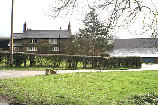
Borough Fen is a civil parish in the City of Peterborough unitary authority in Cambridgeshire, England. The parish is to the north of Peterborough city centre, just below the county border with Lincolnshire. Much of the land in the 19th century was owned by Sir Culling Eardley, 3rd Baronet, a strong supporter of the local boys' school. The land has predominantly been used for agriculture and cattle farming which is still a significant employment sector today.

Described by John Marius Wilson in 1870 as "BOROUGH-FEN (Ville), an extra-parochial tract in Peterborough district, Northampton; 5 miles N by E of Peterborough. Acres, 3,130. Real property, £6,086. Pop., 202. Houses, 31."

<span class="mw-page-title-main">Hunsonby</span> Human settlement in England

Hunsonby is a village and civil parish in the Eden district of Cumbria, England, 7 miles (11 km) north east of Penrith. The parish is located 28 miles (45 km) south east of the city of Carlisle. Within the parish is the ancient stone circle of Long Meg and Her Daughters but not the nearby standing stone of Little Meg which is located near Langwathby. In 2011 the Census reported the parish to have a total population of 388.

<span class="mw-page-title-main">Pitchford</span> Human settlement in England

Pitchford is a small village in the English county of Shropshire. It is located between Cantlop and Acton Burnell and stands on an affluent of the River Severn. Pitchford takes its name from a bituminous spring/pitch in the village, located near The Row Brook.

<span class="mw-page-title-main">Thwing, East Riding of Yorkshire</span> Village in the East Riding of Yorkshire, England

Thwing is a village and civil parish in the Yorkshire Wolds, in the East Riding of Yorkshire, England.

Doncaster was a rural district in the West Riding of Yorkshire, England from 1894 to 1974.

<span class="mw-page-title-main">Holborn District (Metropolis)</span>

Holborn was a local government district in the metropolitan area of London to the north west of the City of London from 1855 to 1900.

<span class="mw-page-title-main">St Giles District (Metropolis)</span>

St Giles District was a local government district in the metropolitan area of London, England from 1855 to 1900. The district was created by the Metropolis Management Act 1855, and comprised the civil parish of St Giles in the Fields and St George Bloomsbury, Middlesex: the two parishes had been combined for civil purposes in 1774. The district was abolished in 1900 and its former area became part of the Metropolitan Borough of Holborn. The civil parish was abolished in 1930. It is now part of the London Borough of Camden.

<span class="mw-page-title-main">Whitgreave</span> Human settlement in England

Whitgreave is a very small village a few miles to the NNW of Stafford situated midway between the M6 motorway to the west and the A34 trunk road to the east.

<span class="mw-page-title-main">Ryton, Shropshire</span> Human settlement in England

Ryton is a village and civil parish in Shropshire, England, in the district of Bridgnorth. It lies about one mile north north west of Beckbury. The civil parish originates during Norman times, and appears as "Ruitone" in the Domesday book of 1086. Ryton was part of the Saxon parish of Shifnal, but became separate at some point during the 12th century because there is mention of a priest at Ryton named Bernard in 1186.

<span class="mw-page-title-main">Millington, Cheshire</span> Human settlement in England

Millington is a former civil parish, now in the parishes of Millington and Rostherne and Little Bollington with Agden, in the Cheshire East district, in the ceremonial county of Cheshire, England. The parish was 8 miles (13 km) from Warrington and 3 miles (5 km) from Altrincham. Its name is a "relic of Saxon clanship – the ton or town of the Millings". The parish is primarily agricultural, with a number of farms including Moss House Farm, Newhall Farm, Mereside Farm, Boothbank Farm and Stonedelph Farm. Millington has been recently described on Britain Streets as a "hamlet or isolated settlement in the inhabited countryside". Millington is situated within the market town Macclesfield. The M56 motorway was close to the parish, which allows travel into areas of Warrington and Manchester, 13 miles (21 km) and 14 miles (23 km) away respectively. In 2011 the parish had a population of 234.

<span class="mw-page-title-main">Wootton, Staffordshire</span> Human settlement in England

Wootton is a village and civil parish in Staffordshire, England. The village is situated approximately 20 miles (30 km) east from Stoke-on-Trent and 20 miles (30 km) northwest from Derby.

<span class="mw-page-title-main">Standon, Staffordshire</span> Human settlement in England

Standon is a village and civil parish in the Stafford district, in the county of Staffordshire, England. Standon has a church called Church of All Saints and one school called All Saints C of E First School. In 2001 the population of the civil parish of Standon was 823, and in the 2011 census it had a population of 879.

The Warminster and Westbury Rural District was a rural district in Wiltshire, England from 1935 to 1974.

<span class="mw-page-title-main">Clumber and Hardwick</span> Civil parish in England

Clumber and Hardwick is a civil parish in the Bassetlaw district, in the county of Nottinghamshire, England. The parish includes the settlement of Hardwick Village and Clumber Park, a country park. In the UK census of 2021 the parish had a population of 66. The parish lies in the north west of the county, and south west within the district. It is 125 miles north west of London, 22 miles north of the city of Nottingham, and 3½ miles south east of the market town of Worksop.The parish touches Babworth, Carburton, Elkesley, Perlethorpe cum Budby and Welbeck. The parish was formed on 1 April 1994. The area is within Sherwood Forest and has close historical associations with the Dukes of Newcastle, being part of a wider region known as The Dukeries. There are 26 listed buildings in Clumber and Hardwick.

The lands common to Axminster and Kilmington civil parishes are an area of meadowland on the banks of the River Axe that is shared between the civil parishes of Axminster and Kilmington in East Devon. The lands common to the two parishes are close to Newenham Abbey, which is in the parish of Axminster.

References

  1. 1 2 "White's "Directory of Nottinghamshire," 1853" . Retrieved 26 April 2012.
  2. "Distance from Carburton to Nottingham" . Retrieved 26 April 2012.
  3. "Distance from Carburton to London" . Retrieved 26 April 2012.
  4. "'Carburton – Carlisle', A Topographical Dictionary of England (1848), pp. 511–520" . Retrieved 26 April 2012.
  5. "Chursh History and Records" . Retrieved 26 April 2012.
  6. "1881 Census of England and Wales, Tables: Area, Houses and Population in Registration Counties, Table 4: " Area, Houses, and Population of Civil Parishes in the several Registration Sub-Districts in 1871 and 1881"" . Retrieved 26 April 2012.
  7. "1891 Census of England and Wales, Area, Houses and Population: Registration Areas and Sanitary Districts, Table 2: " Area and Population in Registration Districts and Sub-Districts and in Civil Parishes"" . Retrieved 26 April 2012.
  8. "1911 Census of England and Wales, Census Returns of England and Wales, 1911, giving details of Areas, Houses, Families or separate occupiers, and Population:- Registration Areas, Table 5: " Registration Counties, Districts and Sub-districts with their constituent civil parishes. – Urban or Rural District in which each parish is situated; Area; families or separate occupiers, and population, 1901 and 1911; and population enumerated in Institutions, large establishments, and on vessels, &c., 1911"" . Retrieved 26 April 2012.
  9. "1921 Census of England and Wales, County Report (Sample Report Title: Census 1921: England and Wales: Series of County Parts. Counties of Merionethshire, Montgomeryshire and Radnorshire), Table 3: " Population, Acreage, Private Families and Dwellings"" . Retrieved 26 April 2012.
  10. "1921 Census of England and Wales, County Report (Sample Report Title: Census 1921: England and Wales: Series of County Parts. Counties of Merionethshire, Montgomeryshire and Radnorshire), Table 3: " Population, Acreage, Private Families and Dwellings"" . Retrieved 26 April 2012.
  11. "1931 Census of England and Wales, County Report Part I (Sample Report Title: Census 1931: England and Wales: Series of County Parts, Part I. County of Glamorganshire), Table 3: " Population, Acreage, Private Families and Dwellings"" . Retrieved 26 April 2012.
  12. "1951 Census of England and Wales, County Report (Sample Report Title: Census 1951: England and Wales: County Report: Nottinghamshire), Table 3: " Acreage, Population, Private Households and Dwellings for AC, MB, UD, RD; Wards of CB, MB; CP, NT"" . Retrieved 26 April 2012.
  13. "1961 Census of England and Wales, County Report (Sample Report Title: Census 1961: England and Wales: County Report: Staffordshire), Table 3: " Acreage, Population, Private Households and Dwellings for LAA, Wards, CP in RD, Con, NT"" . Retrieved 26 April 2012.
  14. "1961 Census of England and Wales, County Report (Sample Report Title: Census 1961: England and Wales: County Report: Staffordshire), Table 3: " Acreage, Population, Private Households and Dwellings for LAA, Wards, CP in RD, Con, NT"" . Retrieved 26 April 2012.
  15. "2001 Census. Parish headcount for Carburton" . Retrieved 26 April 2012.
  16. UK Census (2011). "Local Area Report – Clumber and Hardwick parish (E04007854)". Nomis. Office for National Statistics . Retrieved 17 January 2024.
  17. UK Census (2021). "2021 Census Area Profile – Carburton parish (E04007795)". Nomis. Office for National Statistics . Retrieved 16 January 2024.
  18. "1881 Census of England and Wales, Ages, Table 10, 'Occupations of Males and Females in the Division and its Registration Counties'" . Retrieved 26 April 2012.
  19. "1881 Census of England and Wales, Tables: Area, Houses and Population in Registration Counties, Table 4: " Area, Houses, and Population of Civil Parishes in the several Registration Sub-Districts in 1871 and 1881"" . Retrieved 30 April 2012.
  20. "1921 Census of England and Wales, County Report (Sample Report Title: Census 1921: England and Wales: Series of County Parts. Counties of Merionethshire, Montgomeryshire and Radnorshire), Table 3: " Population, Acreage, Private Families and Dwellings"" . Retrieved 30 April 2012.
  21. "1931 Census of England and Wales, County Report Part I (Sample Report Title: Census 1931: England and Wales: Series of County Parts, Part I. County of Glamorganshire), Table 3: " Population, Acreage, Private Families and Dwellings"" . Retrieved 30 April 2012.
  22. "1951 Census of England and Wales, County Report (Sample Report Title: Census 1951: England and Wales: County Report: Nottinghamshire), Table 3: " Acreage, Population, Private Households and Dwellings for AC, MB, UD, RD; Wards of CB, MB; CP, NT"" . Retrieved 30 April 2012.
  23. "1961 Census of England and Wales, County Report (Sample Report Title: Census 1961: England and Wales: County Report: Staffordshire), Table 3: " Acreage, Population, Private Households and Dwellings for LAA, Wards, CP in RD, Con, NT"" . Retrieved 30 April 2012.
  24. "Houses prices in S8O from 2011 to 2012, pages 1–43" . Retrieved 30 April 2012.
  25. "Clumber Park" . Retrieved 26 April 2012.
  26. 1 2 "H Gill, Summer excursion 1914: Carburton church, Transactions of the Thoroton Society, 18 (1914" . Retrieved 26 April 2012.
  27. 1 2 "Carburton Church" . Retrieved 1 May 2012.