
Chesterfield is a market town in the Borough of Chesterfield, Derbyshire, England. It is 24 miles (39 km) north of Derby and 11 miles (18 km) south of Sheffield at the confluence of the River Rother and River Hipper. In 2011, the built-up-area subdivision had a population of 88,483, making it the second-largest settlement in Derbyshire, after Derby. The wider borough had a population of 103,801 in 2011. In 2011, the town had a population of 76,753.

Heanor (/ˈhiːnə/) is a town in the Amber Valley district of Derbyshire in the East Midlands of England. It lies 8 miles (13 km) north-east of Derby and forms, with the adjacent village of Loscoe, the civil parish and town council-administered area of Heanor and Loscoe, which had a population of 17,251 in the 2011 census.
Sandiacre is a village and civil parish in the borough of Erewash in Derbyshire, in the East Midlands region of England adjoining the border with Nottinghamshire. The population of the parish was 8,889 at the 2011 Census.
Ruddington is a large village in the Borough of Rushcliffe in Nottinghamshire, England. The village is 5 miles (8 km) south of Nottingham and 11 miles (18 km) northwest of Loughborough. It had a population of 6,441 at the 2001 Census, increasing to 7,216 at the 2011 Census and 7,674 in 2021. Ruddington is twinned with Grenay, France.
Car Colston is an English village and civil parish in the Rushcliffe borough of Nottinghamshire. The population of the civil parish at the time of the 2011 census was 185.
Rhodesia is a village and civil parish in the Bassetlaw district of Nottinghamshire, England. The village lies just west of the town of Worksop, and approximately 20 miles (32 km) east-southeast of Sheffield. At the 2011 Census, the population of the civil parish was 982, and this increased to 1,173 at the 2021 census.

Tibshelf is a village and civil parish in the Bolsover District in Derbyshire, England. Located between the towns of Clay Cross, Shirebrook, Mansfield and Chesterfield. It had a population at the 2001 UK census of 3,548, increasing to 3,787 at the 2011 Census, and increasing to 4,348 at the 2021 Census Tibshelf shares its boundaries with the villages of Morton, Pilsley, Newton, Teversal and Hardstoft.

Shireoaks is a former pit village and civil parish in Nottinghamshire, located between Worksop and Thorpe Salvin on the border with South Yorkshire. The population of the civil parish was 1,432 at the 2011 census, and this increased to 1,774 in the 2021 census. Shireoaks colliery was opened in 1854. It was closed on 25 May 1991 and was capped in August 1992. The depth of the shaft was 483.5m and the shaft's diameter was 3.66m.

Orston is an English village and civil parish in the Rushcliffe borough of Nottinghamshire, 15 miles east of Nottingham. It borders the parishes of Scarrington, Thoroton, Flawborough, Bottesford and Elton on the Hill. The population at the 2011 census was 454.

Wisborough Green is a village and civil parish in the north of the Chichester district of West Sussex, England, 2 miles (3.2 km) west of Billingshurst on the A272 road.

Greasley is a civil parish north west of Nottingham in Nottinghamshire, England. Although it is thought there was once a village called Greasley, there is no settlement of that name today as it was destroyed by the Earl of Rutland. The built up areas in the parish are Beauvale, Giltbrook, Moorgreen, Newthorpe, Watnall and parts of Eastwood, Kimberley and Nuthall. There is also a small hamlet known as Bog-End. The parish is one of the largest in Nottinghamshire at 7.63 square miles (19.8 km2), the 2001 UK Census reporting it had a total population of 10,467, increasing to 11,014 in 2011, and 11,241 at the 2021 census.

Sawley is a village and civil parish within the Borough of Erewash, in southeast Derbyshire, England. With a slightly higher than average number of people over 65, the population of just the civil parish was measured at 6,629 as at the 2011 Census.

Misterton is a village and civil parish in the Bassetlaw district of Nottinghamshire, England. The parish population at the 2011 census was 2,140, and has risen to 2,191 residents in the 2021 census.

Clayworth is a village and civil parish in Nottinghamshire, England. At the time of the 2001 census it had a population of 319, increasing to 419 at the 2011 Census. In the Census 2021 Clayworth alone was reported to be 311 residents. The village is located 6 miles (9.7 km) north-east of Retford, on the River Idle. Clayworth appears as Clavord in the Doomsday Book, where 37 households were registered in the parish, which in the context of the Doomsday Book was considered to be a large population. At that time Clayworth paid low amounts of tax at 2 geld units. By 1769 Clayworth appears as Cloworth. Clayworth was described in John Bartholomew's Gazetteer of the British Isles of 1887 as having a population of 439, with 2,076 acres of land.

Welham is a hamlet in the civil parish of Clarborough and Welham, of Bassetlaw district, in the county of Nottinghamshire, England. It is 130 miles north of London, 28 miles north east of the city of Nottingham, and 2 miles north east of the market town of Retford.

Scaftworth is a hamlet and civil parish within the Bassetlaw district of north Nottinghamshire, England.
Clarborough and Welham is a civil parish in the Bassetlaw district, in the county of Nottinghamshire, England. The parish includes the village of Clarborough and the hamlet of Welham. In 2021 the parish had a population of 1,041. It is 130 miles north of London, 28 miles north east of the city of Nottingham, and 2 miles north east of the market town of Retford. The parish touches Hayton, North and South Wheatley, North Leverton with Habblesthorpe and Sturton Le Steeple. There are 14 listed buildings in Clarborough and Welham.

Scofton is a hamlet in the Bassetlaw district of northern Nottinghamshire, England. It is 130 miles (210 km) north west of London, 25 miles (40 km) north of the county town and city of Nottingham, and 3 miles (4.8 km) east of the nearest town Worksop. Having a shared modern history with nearby Osberton Hall, it is sometimes referred to as Scofton-with-Osberton. Other close neighbours are Bilby and Rayton which also have historical associations.

Brampton is a civil parish in North East Derbyshire, England, with a population of 1,201 in 2011. Lying 130 miles (210 km) north west of London, 20 miles (32 km) north of Derby, and 2 miles (3.2 km) west of the market town of Chesterfield, Brampton encompasses part of the Peak District national park to the west, and shares a border with the Borough of Chesterfield, Barlow, Baslow and Bubnell, Beeley, and Holymoorside and Walton. The parish contains a number of settlements including the village it was named after, but does not include the nearby built-up suburb of Brampton which is now within the Chesterfield unparished area.
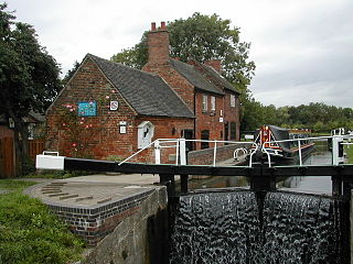
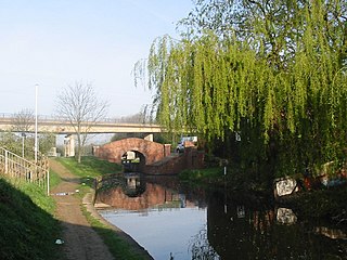
Wiseton is a civil parish in the Bassetlaw District of Nottinghamshire, England. The parish contains 14 listed buildings that are recorded in the National Heritage List for England. All the listed buildings are designated at Grade II, the lowest of the three grades, which is applied to "buildings of national importance and special interest". The parish contains the village of Wiseton and the surrounding area. The original Wiseton Hall was replaced in 1962 by a building which is not listed, but a number of buildings in the grounds are listed, including the stable range and a pair of entrance lodges. The Chesterfield Canal passes through the parish, and two bridges crossing it are listed. The other listed buildings include estate cottages, a farmhouse, a public house, two ice houses, and a model dairy.


