
Dunton is a village and civil parish in the Aylesbury Vale district of Buckinghamshire, England. The village is situated approximately 8 miles (13 km) north from Aylesbury and 4 miles (6.4 km) south-east from Winslow.

Finningley is a village and civil parish in the City of Doncaster, South Yorkshire, England. Historically in Nottinghamshire, it lies on the A614 road between Bawtry and Thorne, about 6 miles south-east of Doncaster. In the 2011 census, it had a population of 1,497. The Finningley ward of Doncaster Metropolitan Borough Council covers 16.8 square miles, including the villages of Auckley, Branton, Blaxton, Hayfield and Bessacarr Grange, and part of Cantley.

Blidworth is a village and civil parish approximately five miles east of Mansfield, Nottinghamshire, England. The population of the civil parish at the 2011 census was 4,457, this dropped to 4,295 in the 2021 census. Its history can be traced back to the 10th century. The area around Main Street, west of Beck Lane and including the church, is the older portion of Blidworth, containing historic buildings. Many of the current houses were built in the first half of the 20th century to provide housing for workers at Blidworth Colliery (1926–1989). These are mainly in estates north of Dale Lane. Outside of Blidworth village but within the parish, Blidworth Bottoms is a hamlet about 0.5 km south of Blidworth. Haywood Oaks is the portion of the village south of Dale Lane and the south eastern rural area of the parish surrounding Haywood Oaks Lane.
Bunny is a village and civil parish located in the Rushcliffe borough of Nottinghamshire, England. The parish had a population measured at 689 in the 2011 census, increasing to 715 residents at the 2021 census. It is on the A60, 7 miles (11 km) south of Nottingham, south of Bradmore and north of Costock.
Car Colston is an English village and civil parish in the Rushcliffe borough of Nottinghamshire. The population of the civil parish at the time of the 2011 census was 185, falling to 171 at the 2021 census.

Shelford is a village and civil parish in the Rushcliffe borough of Nottinghamshire. The population of the former civil parish of Shelford and Newton at the 2011 census was 673. Shelford has since been created as a separate parish which counted 267 residents at the 2021 census. It is near Radcliffe on Trent. It has an old manor house, a church, a caravan park and bar. It also has a pub restaurant, The Earl of Chesterfield Arms.
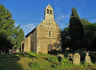
Kneeton is a hamlet and civil parish in the county of Nottinghamshire, England. The population as of the 2011 census remained less than 100 so was included in the civil parish count for Screveton, it was however reported as 47 residents at the 2021 census. The village lies on the A46 road between Nottingham and Newark and is on the escarpment of the Trent Hills that sit above the flood plain of the River Trent. RAF Syerston is nearby. There is a railway station at Lowdham. The church is 14th century Grade II listed, and dedicated to St. Helen. A mid-18th century Grade II listed barn survives at Hall Farm, Kneeton.

Clipstone is a former mining village in the Newark and Sherwood district of Nottinghamshire, England. The population of the civil parish was 3,469 at the 2001 census, increasing to 4,665 at the 2011 census, and substantially more so to 6,185 at the 2021 census.

Basford is a northerly suburb of Nottingham, in Nottinghamshire, England, incorporated into the city in 1877. It gave its name to Basford Rural District, which existed from 1894 to 1974. The ward population at the 2011 census was 16,207, estimated at 16,779 in 2019. Next to Old Basford is New Basford, which is mainly Victorian. Basford lies close to the River Leen, a tributary of the River Trent. It is linked to Nottingham City Centre to the south and Hucknall and Bulwell to the north by the Nottingham Express Transit tram service.

Lambley is an English village and civil parish near Nottingham, England, hardly touched by urbanisation, as it lies in a green belt. The population recorded in the 2011 census was 1,247, marginally falling to 1,231 at the 2021 census. Its proximity to Nottingham has tended to raise the price of its real estate.

Granby is a small village in the Rushcliffe district of Nottinghamshire, England. It lies in the Vale of Belvoir.

Oxton is a village in Nottinghamshire, England, with 568 residents at the 2011 census, falling marginally to 566 at the 2021 census. It is located 5 miles (8 km) west of Southwell, 5 miles (8 km) north of Lowdham, 10 miles (16 km) north-east of Nottingham and 2 miles (3 km) north-east of Calverton, and lies on the B6386, and is very close to the A6097 trunk road.
Kirklington is a village and civil parish in the Newark and Sherwood district of Nottinghamshire, England. The population as of the 2011 census was 400, falling to 388 at the 2021 census. Kirklington lies on the A617 road between Newark and Mansfield.

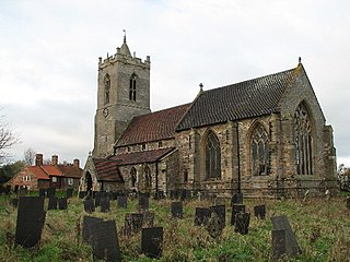
Whatton-in-the-Vale is a village and civil parish in the Rushcliffe district, in the county of Nottinghamshire, England. It lies in the Vale of Belvoir, with the River Smite to the west and a subsidiary, the River Whipling to the east, mainly north of the trunk A52 road, 12 miles (19 km) east of Nottingham. The parish had a population of 843 at the 2011 census, increasing to 874 at the 2021 census.

Hockerton is a village and civil parish in Nottinghamshire, England. It is 2 miles from the town of Southwell on the A617 between Newark and Mansfield. Fewer than 60 houses are situated around the church, the Spread Eagle pub and village hall. The population at the 2011 census was 146, increasing to 183 at the 2021 census. The local properties range from the carbon neutral housing of the Hockerton Housing Project to converted barns, 1960s and 1970s housing together with much older houses and a 19th-century Rectory. The parish church of St Nicholas is Norman with an aisleless nave and a 14th-century chancel.

Misterton is a village and civil parish in the Bassetlaw district of Nottinghamshire, England. The parish population at the 2011 census was 2,140, and has risen to 2,191 residents in the 2021 census.

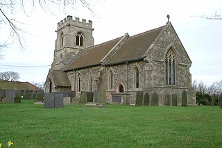
Thoroton is a small English village and civil parish in the borough of Rushcliffe, and the county of Nottinghamshire, with a population of 112 at the 2011 census, and increasing to 130 at the 2021 census. The village has conservation area status. Its Anglican parish church is a Grade I listed building.
Edingley is a village in the Newark and Sherwood district of Nottinghamshire, England. According to the 2001 census it had a population of 390, increasing to 443 at the 2011 census, and falling to 401 at the 2021 census. It is located 3 miles north-west of Southwell.

Elkesley is a village in Nottinghamshire, England. According to the 2001 census it had a population of 805, increasing to 822 at the 2011 Census, and 852 in 2021. It is located 6 miles south of Retford.
Scarrington is an English civil parish and small village in the Rushcliffe borough of Nottinghamshire, adjacent to Bingham, Car Colston, Hawksworth, Orston and Aslockton. Its 968 acres had a population in the 2011 census of 183, falling to 167 at the 2021 census. It lies at Ordnance Survey grid reference SK7341 in the undulating farmland of the Vale of Belvoir, some 2 miles (3.2 km) from the town of Bingham and from a stretch of the Roman Fosse Way (A46) between Newark and Leicester. It is skirted by the A52 road between Nottingham and Grantham.


