North and South Wheatley

Last updated

North and South Wheatley
Civil parish
St.Peter and St.Paul's church, North Wheatley - geograph.org.uk - 78986.jpg
Church of St Peter and St Paul in North Wheatley
North and South Wheatley
Map of parish area
Nottinghamshire UK location map.svg
Red pog.svg
North and South Wheatley
Location within Nottinghamshire
Area4.43 sq mi (11.5 km2)  [1]
Population610 (2021)
  Density 138/sq mi (53/km2)
Created2015
OS grid reference SK 7686
  London 130 mi (210 km)  SE
District
Shire county
Region
Country England
Sovereign state United Kingdom
Settlements North Wheatley and South Wheatley
Post town RETFORD
Postcode district DN22
Dialling code 01427
Police Nottinghamshire
Fire Nottinghamshire
Ambulance East Midlands
UK Parliament
Website www.northandsouthwheatleyparishcouncil.gov.uk
List of places
UK
England
Nottinghamshire
53°21′43″N0°51′22″W / 53.362°N 0.856°W / 53.362; -0.856

North and South Wheatley
Map
South Wheatley church ruins The ruins of St. Helens church, South Wheatley (geograph 3188745).jpg
South Wheatley church ruins

North and South Wheatley is a civil parish in the Bassetlaw district, in the county of Nottinghamshire, England. The parish includes the villages of North Wheatley and South Wheatley. In 2021 the parish had a population of 610 residents. [2] [1] It is 130 miles north of London, 30 miles north east of the county town of Nottingham, and 5 miles north east of the Nottinghamshire town of Retford. The parish touches Bole, Clarborough and Welham, Clayworth, Hayton, Saundby, Sturton Le Steeple and West Burton. [3] There are 18 listed buildings in North and South Wheatley. [4]

Contents

Geography

Location

North and South Wheatley lay in the north of the county, and the east of the district.

It is surrounded by the following local villages:

The parish is approximately 2 miles in width, by 3 miles.

Settlements

The parish consists of one urban area divided into two distinct villages: [5]

North Wheatley

This lies north of the Wheatley Beck stream, with the A620 Wheatley Bypass road providing a northern boundary for the village. This is the larger settlement and maintains most of the housing in the parish and church.

South Wheatley

This is south of the Wheatley Beck stream. Much smaller but mainly residential, it maintains amenities such as a primary school, village hall and some leisure facilities. [6]

Landscape

Predominantly, many of the parish residents are clustered around the urban area formed by the two villages. Outside of this is a light scattering of farms, farmhouses, auxiliary buildings and cottages amongst a wider mainly farmland setting. A few small wooded areas exist throughout the parish.

Water features

The Wheatley Beck stream flows west to east through the parish and separates the two villages, before eventually draining into the River Trent.

The Oswald Beck feeds into the Wheatley Beck east of the parish, but forms a portion of the lower east and south boundary.

Topography

The parish overall is low-lying, at approximately 15 metres (49 ft) in the east. The village areas ranges from 23–32 metres (75–105 ft), with the ground rising in the far west and south of the parish to 50–60 metres (160–200 ft). The peak of the parish is at Wheatley Grange farm 1+13 miles (2.13 km) north of the villages, with a land elevation there of 65 m (213 feet).

Governance and demography

The two settlements North Wheatley and South Wheatley are combined as North and South Wheatley parish for administrative identity.

It is managed at the first level of public administration by North and South Wheatley Parish Council.

In 2011 North Wheatley parish reported a population of 509. [1] South Wheatley last provided a population count in 2001 of 102 residents. [7] In the Census 2021 results, a full parish count was given of 610 residents. [2]

At district level, the wider area is managed by Bassetlaw District Council.

Nottinghamshire County Council provides the highest level strategic services locally.

History

Toponymy

Wheatley was recorded in the Domesday Book as Watelaie. [8] The parish was formed on 1 April 2015 from the then independent parishes of "North Wheatley" and "South Wheatley". [9]

Roman period

The villages dates back to Romans times and prior. The Roman Road from Lincoln crosses the River Trent at Littleborough and goes through Wheatley before reaching Doncaster. Roman coins were found in the village. There is proof of Roman soldiers being in Wheatley, as a Roman centurion's tombstone was discovered under the foundation of the present church in North Wheatley church tower when major restoration work was being carried out during the 1930s. Part of this tombstone is presently being displayed in the church. [10]

There are numerous theories about a Roman settlement in Wheatley, a possible Roman villa on the playing field, but no hard evidence. An 1899 OS map of Wheatley shows a Roman pitchment, situated on Low Street as the road forks into Top Street, [11] the term pitchment can mean both a road and the floor area of a dwelling, of which it could have been either, but more likely it was the road.

Numerous coins and fragments of pottery from the Roman period have been found around Wheatley, mainly from Wheatley Grange and Wheatley Wood when excavations took place to create a large pond for drainage purposes, this high point could have been the site of a look-out post. The fragments of pottery are mainly Samian ware, a red glazed decorated ware imported by the Romans from northern France. Roman coins have also been found on Chapel field, situated alongside the road. [10] A Roman fantail bow brooch with pin and catchplate were also found in South Wheatley, as well as coins and a love token in the chapel field. These items are now in the Bassetlaw Museum in Retford. [10]

Medieval age to present

Around the time of Domesday (1086), Wheatley is recorded of having come under part ownership of the Archbishop of York. The rest came under the tenure of Roger de Busli. Landowners in later centuries became fragmented, they included the Markham family, the Earl of Shrewsbury, Lord Middleton and Marquess of Dorchester. [12] [13]

The Grade II* listed Old Hall at North Wheatley has over the door the arms of Thomas Cartwright, and dates from 1673, possibly being the oldest dormitory building in the village. [14] It is unclear if this Cartwright family were related to the Marnham family of the same name, due to the different coat of arms in use by both. [15] Many of the heritage residences were primarily farmhouses for housing agricultural workers as the parish was mainly rural, with much of the surrounding land used for that purpose. [16] [17]

Community & leisure

A village hall is at South Wheatley. [18]

There is one public house, The Sun Inn, in North Wheatley. [19]

The Recreation Ground in South Wheatley lends itself to multi-use community events and sport activities, along with a children's playground. [6]

The Trent Valley Way long-distance path runs through the parish and villages.

Landmarks

Development protection area

There is a conservation area defined for much of North Wheatley, along with a portion of South Wheatley. [20]

Listed buildings

There are 18 listed buildings, including: [4]

Religious sites

North Wheatley

The North Wheatley churches are now shared amongst one congregation worshipping alternatively in the two buildings. It is a local ecumenical partnership of Anglican and Methodist churches. [21]

Church of St Peter and St Paul

The church was built in the 13th century, and is dedicated to St Peter and St Paul. [22] It has a tower with 5 bells, but the Chancel was rebuilt in 1824. [23] In 1967 it was registered as a Grade II* listed building. [24] It is still in use with a church service on most Sundays at 10:30 am in either Church or Chapel. [25]

The churchyard contains a Calvary Cross (Grade II listed) that commemorates the men of North and South Wheatley who died in World War I. [26]

North Wheatley Methodist Chapel

This is located on Low Street. It was built in 1891 for Wesleyan worshippers. [21]

South Wheatley

Church of St Helen

The church was thought to have been built in the 11th century, the surviving ruins of St Helen's consist only of an arch and its tower. The church was declared redundant in 1883 and subsequently demolished, its walls pulled down by traction engines. The stone from the church was used to repair walls in the village, with the altar being taken to St Peter and St Paul church in North Wheatley. [27]

Education

North Wheatley Church of England primary school is in South Wheatley. [28]

Sport

Several group activities take place primarily in South Wheatley on the multi-use Recreation Ground: [6]

Bowls takes place on its own dedicated field with a local club. [6]

Related Research Articles

<span class="mw-page-title-main">Bassetlaw Wapentake</span>

Bassetlaw was a wapentake in the English county of Nottinghamshire. The wapentake covered an area in the north of the county, roughly equivalent to the modern Bassetlaw local government district. The wapentake was divided into the divisions of Hatfield, North Clay and South Clay.

<span class="mw-page-title-main">North Wheatley</span> Human settlement in England

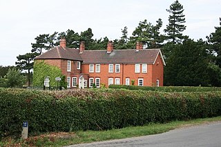
North Wheatley is a village and former civil parish, now in the parish of North and South Wheatley, in Bassetlaw district, in the county of Nottinghamshire, England. At the time of the 2001 census it had a population of 489, increasing to 509 at the 2011 census. It is located 6 miles north-east of Retford. The village has a number of 17th century brick houses. The Old Hall on Low Street/Church Hill is dated 1673, with the arms of the Cartwright family. The parish church of St Peter and St Paul was restored in 1896. Many farms in the area have dovecotes, either as free-standing buildings or above farm buildings. On 1 April 2015 the civil parish was merged with South Wheatley to form "North and South Wheatley".

<span class="mw-page-title-main">Welham, Nottinghamshire</span> Settlement in Nottinghamshire, England

Welham is a hamlet in the civil parish of Clarborough and Welham, of Bassetlaw district, in the county of Nottinghamshire, England. It is 130 miles north of London, 28 miles north east of the city of Nottingham, and 2 miles north east of the market town of Retford.

<span class="mw-page-title-main">St John the Baptist Church, Clarborough</span> Church in Clarborough, England

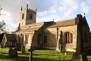
St John the Baptist's Church is a Grade I listed Church of England parish church in Clarborough, Nottinghamshire, England.

<span class="mw-page-title-main">Our Lady and St Peter's Church, Bothamsall</span> Church in Bothamsall, England

Our Lady and St Peter's Church, Bothamsall is a Grade II listed parish church in the Church of England in Bothamsall. The church is part of the Lound Hall Estate, Bothamsall. The buildings repair costs are procured by the Lord of the manor.

<span class="mw-page-title-main">St Peter's Church, Gamston</span> Church in Bassetlaw, England

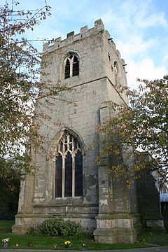
St Peter's Church, Gamston is a Grade I listed parish church in the Church of England in Gamston, Bassetlaw.

<span class="mw-page-title-main">St Paul's Church, West Drayton</span> Church in Nottinghamshire, England

St Paul's Church is a Grade II* listed parish church in the Church of England in West Drayton, Nottinghamshire.

<span class="mw-page-title-main">All Saints' Church, South Leverton</span> Church in South Leverton, England

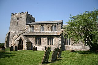
All Saints’ Church, South Leverton is a Grade II* listed parish church in the Church of England in South Leverton, Nottinghamshire.

<span class="mw-page-title-main">West Drayton, Nottinghamshire</span> Human settlement in England

West Drayton is a village and civil parish in the Bassetlaw district in the county of Nottinghamshire, England. It lies 24 miles (39 km) north east of Nottingham and 4 miles (6.4 km) south of Retford.

<span class="mw-page-title-main">Scaftworth</span> Hamlet and civil parish in Nottinghamshire, England

Scaftworth is a hamlet and civil parish within the Bassetlaw district of north Nottinghamshire, England.

<span class="mw-page-title-main">Styrrup with Oldcotes</span> Civil parish in England

Styrrup with Oldcotes is a civil parish in the Bassetlaw district, within the county of Nottinghamshire, England. The overall area had a population of 731 at the 2021 census, an increase from 684 at the 2011 census. The parish lies in the north of the county. It is 138 miles north west of London, 31 miles north of the city of Nottingham, and 15 miles east of the city of Sheffield. The parish rests alongside the county border with South Yorkshire.

<span class="mw-page-title-main">Headon cum Upton</span> Civil parish in England

Headon cum Upton is a civil parish in the Bassetlaw district, in the county of Nottinghamshire, England. The parish includes the villages of Headon, Upton and the hamlet of Nether Headon. The parish is adjacent to Askham, Gamston, East Drayton, Eaton, Grove, Rampton and Woodbeck, Stokeham and Treswell. In the 2021 census, the parish had a population of 192. The area is 3.5 miles south east of the nearest market town Retford, 26 miles north east of the county town Nottingham and 125 miles north of London. Headon cum Upton shares a parish council with Grove and Stokeham. There are 6 listed buildings in Headon cum Upton.

<span class="mw-page-title-main">Rampton and Woodbeck</span> Civil parish in England

Rampton and Woodbeck is a civil parish in the Bassetlaw district, within the county of Nottinghamshire, England. The overall area had a population of 1,077 at the 2021 census. The parish lies in the north east of the county. It is 125 miles north west of London, 27 miles north east of the city of Nottingham, and 5 miles south east of the town of Retford. The parish rests alongside the county border with Lincolnshire. It is the site of Rampton Secure Hospital, which is one of only three high security psychiatric hospitals in England.

<span class="mw-page-title-main">Headon, Nottinghamshire</span> Human settlement in England

Headon is a village in Headon cum Upton civil parish, in the Bassetlaw district, of the county of Nottinghamshire, England. The village is adjacent to the villages of Upton, Nether Headon, East Drayton, Eaton, Gamston, Woodbeck and Stokeham. In 2011 the parish, together with Stokeham had a population of 253. The area is 3.5 miles south east of the nearest market town Retford, 26 miles north east of the county town Nottingham and 125 miles north of London. There are 2 listed buildings in Headon village.

<span class="mw-page-title-main">Nether Headon</span> Human settlement in England

Nether Headon is a hamlet in Headon cum Upton civil parish, within the Bassetlaw district, of the county of Nottinghamshire, England. It is 3.5 miles south east of the nearest market town Retford, 26 miles north east of the county town Nottingham and 125 miles north of London. The hamlet is adjacent to the villages of Upton, Headon, East Drayton, Eaton, Grove, Woodbeck and Stokeham. In 2011 the parish, together with Stokeham had a population of 253.

<span class="mw-page-title-main">Marnham, Nottinghamshire</span> Civil parish in Nottinghamshire, England

Marnham is a civil parish in the Bassetlaw district, in the county of Nottinghamshire, England. The parish includes the village of Low Marnham and the hamlets of High Marnham and Skegby. In the census of 2021 the parish had a population of 136. The parish lies in the north east of the county, and south east within the district. It is 122 miles north of London, 23 miles north east of the city of Nottingham, and 17 miles north east of the market town of Mansfield. The parish touches Fledborough, Normanton on Trent, South Clifton, Tuxford and Weston. Marnham shares a parish council with Normanton on Trent. There are 7 listed buildings in Marnham.

<span class="mw-page-title-main">South Wheatley, Nottinghamshire</span> Settlement in Nottinghamshire, England

South Wheatley is a village and former civil parish, now within the North and South Wheatley civil parish, of Bassetlaw district, in the county of Nottinghamshire, England. In 2001 South Wheatley parish had a population of 102. It is 130 miles north of London, 30 miles north east of the county town of Nottingham, and 5 miles north east of the Nottinghamshire town of Retford. There are 4 listed buildings in South Wheatley.

<span class="mw-page-title-main">Clarborough and Welham</span> Civil parish in Nottinghamshire, England

Clarborough and Welham is a civil parish in the Bassetlaw district, in the county of Nottinghamshire, England. The parish includes the village of Clarborough and the hamlet of Welham. In 2021 the parish had a population of 1,041. It is 130 miles north of London, 28 miles north east of the city of Nottingham, and 2 miles north east of the market town of Retford. The parish touches Hayton, North and South Wheatley, North Leverton with Habblesthorpe and Sturton Le Steeple. There are 14 listed buildings in Clarborough and Welham.

<span class="mw-page-title-main">Little Gringley</span> Hamlet in Nottinghamshire, England

Little Gringley is a hamlet in the Bassetlaw district of northern Nottinghamshire, England. It is 130 miles (210 km) north of London, 27 miles (43 km) north east of the county town and city of Nottingham, and 1+34 miles (2.8 km) east of the nearest town Retford.

Hayton is a civil parish in the Bassetlaw District of Nottinghamshire, England. The parish contains eleven listed buildings that are recorded in the National Heritage List for England. Of these, one is listed at Grade I, the highest of the three grades, and the others are at Grade II, the lowest grade. The parish contains the village of Hayton and the surrounding countryside. Most of the listed buildings are houses, farmhouses and farm buildings, and the others consist of a church, a war memorial in the churchyard, and two bridges over the Chesterfield Canal.

References

  1. 1 2 3 "North and South Wheatley". City Population De. Retrieved 26 December 2019.
  2. 1 2 UK Census (2021). "2021 Census Area Profile – North and South Wheatley parish (E04012413)". Nomis. Office for National Statistics . Retrieved 14 January 2024.
  3. "North and South Wheatley". Ordnance Survey . Retrieved 26 December 2020.
  4. 1 2 "Listed buildings in North and South Wheatley, Bassetlaw, Nottinghamshire". British Listed Buildings. Retrieved 26 December 2020.
  5. "Custom report - Nomis - Official Labour Market Statistics". www.nomisweb.co.uk. Retrieved 28 December 2020.
  6. 1 2 3 4 "Neighbourhood Plan". www.northandsouthwheatleyparishcouncil.gov.uk. 28 November 2020. Retrieved 28 December 2020.
  7. UK Census (2001). "Local Area Report – South Wheatley Parish (37UC052)". Nomis. Office for National Statistics . Retrieved 27 December 2020.
  8. "Nottinghamshire S-Z". The Domesday Book Online. Retrieved 26 December 2020.
  9. "The Bassetlaw District Council (Reorganisation of Community Governance) Order 2014" (PDF). Local Government Boundary Commission for England . Retrieved 26 December 2020.
  10. 1 2 3 "Brief History". www.northandsouthwheatleyparishcouncil.gov.uk. 24 November 2020. Retrieved 28 December 2020.
  11. "View: Nottinghamshire X.NW (includes: Clarborough; Hayton; North Wheatley; South Wheat... - Ordnance Survey Six-inch England and Wales, 1842-1952". maps.nls.uk. Retrieved 28 December 2020.
  12. "Wheatley's | British History Online". www.british-history.ac.uk. Retrieved 28 December 2020.
  13. "Records of the Manor of North Wheatley, Nottinghamshire, 1633-1935 - Archives Hub". archiveshub.jisc.ac.uk. Retrieved 28 December 2020.
  14. "THE OLD HALL AND ADJOINING OLD HALL FARM HOUSE, North Wheatley - 1275959 | Historic England". historicengland.org.uk. Retrieved 28 December 2020.
  15. "Cartwright Coat of Arms Meanings and Family Crest Artwork". coadb.com. Retrieved 28 December 2020.
  16. GENUKI. "Genuki: North Wheatley, Nottinghamshire". www.genuki.org.uk. Retrieved 28 December 2020.
  17. GENUKI. "Genuki: South Wheatley, Nottinghamshire". www.genuki.org.uk. Retrieved 28 December 2020.
  18. "North and South Wheatley Village Hall". www.northandsouthwheatleyparishcouncil.gov.uk. 24 November 2020. Retrieved 28 December 2020.
  19. "Sun Inn, North Wheatley". whatpub.com. Retrieved 28 December 2020.
  20. "Bassetlaw Open Data - Wheatley". data.bassetlaw.gov.uk. Retrieved 28 December 2020.
  21. 1 2 "North Wheatley Methodist Chapel / Trinity Methodist Circuit" . Retrieved 27 December 2020.
  22. GEN UKI Website
  23. GEN UKI – Whites Directory
  24. Wikipedia Article
  25. North and South Wheatley Village Website
  26. North Wheatley War Memorial
  27. "Remains of Church of St Helen, South Wheatley | Historic England". historicengland.org.uk. Retrieved 27 December 2020.
  28. "Home | North Wheatley Church of England Primary School". www.northwheatleyprimary.net. Retrieved 28 December 2020.