
Finningley is a village and civil parish in the City of Doncaster, South Yorkshire, England. Historically in Nottinghamshire, it lies on the A614 road between Bawtry and Thorne, about 6 miles south-east of Doncaster. In the 2011 census, it had a population of 1,497. The Finningley ward of Doncaster Metropolitan Borough Council covers 16.8 square miles, including the villages of Auckley, Branton, Blaxton, Hayfield and Bessacarr Grange, and part of Cantley.

Aslockton is an English village and civil parish 12 miles (19 km) east of Nottingham and 2 miles (3.2 km) east of Bingham, on the north bank of the River Smite opposite Whatton-in-the-Vale. The parish is also adjacent to Scarrington, Thoroton and Orston and within the Rushcliffe borough of Nottinghamshire. The population was recorded as 974 in the 2011 census, doubling to 1,937 at the 2021 census.

Southwell is a minster and market town, and a civil parish, in the district of Newark and Sherwood in Nottinghamshire, England. It is home to the grade-I listed Southwell Minster, the cathedral of the Anglican Diocese of Southwell and Nottingham. The population of the town was recorded at 7,491 in the 2021 census.
Lowdham is a village and civil parish in the Newark and Sherwood district of Nottinghamshire between Nottingham and Southwell. According to the 2021 census, it had a population of 3,247. Two main roads slicing through the village are the A6097 south-east to north-west and the A612 between Nottingham and Southwell.

Epperstone is an English village and civil parish in mid-Nottinghamshire, located near Lowdham and Calverton. It had a population of 589 at the time of the 2011 census, falling to 517 at the 2021 census. Many inhabitants commute to work or school in Nottingham 9 miles (16 km) to the south-west.
Bilsthorpe is a village and civil parish in the Newark and Sherwood district of Nottinghamshire, England. According to the 2001 census it had a population of 3,076, increasing to 3,375 at the 2011 census, and dropping slightly to 3,365 at the 2021 census. It is located near the junction of the A614 and A617, around five miles south of Ollerton, nine miles east of Mansfield and six miles north-west of Southwell.

Lambley is an English village and civil parish near Nottingham, England, hardly touched by urbanisation, as it lies in a green belt. The population recorded in the 2011 census was 1,247, marginally falling to 1,231 at the 2021 census. Its proximity to Nottingham has tended to raise the price of its real estate.

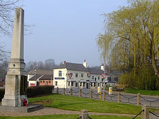
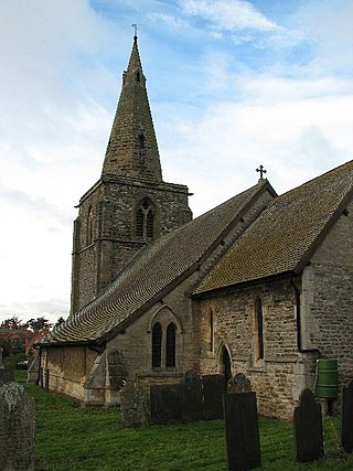
Upton is a small village in Nottinghamshire, England, 2 miles (3.2 km) east of Southwell, 5 miles (8.0 km) west of Newark and 3 miles (4.8 km) south of Hockerton; it lies on the A612 Nottingham-Newark road. In 1889, the village was described as sitting on a bend in the main road, "on the summit of a hill which commands a fine view of the Trent Valley.... The church, which is a prominent feature in the landscape, has a substantial Perpendicular tower crowned by eight pinnacles, and having in the centre a lofty master pinnacle which rises above its neighbours, and so adds materially to the effect."

Fiskerton is a village and former civil parish, now in the parish of Fiskerton cum Morton, in the Newark and Sherwood district, in the county of Nottinghamshire, England. It is on the west bank of the River Trent about 3 miles southeast of Southwell. The waterfront is home to million-pound residential properties, previously residences of merchants and businessmen who commuted in the 1800s to nearby Nottingham by rail from Fiskerton Station. In 1881 the parish had a population of 283.

Oxton is a village in Nottinghamshire, England, with 568 residents at the 2011 census, falling marginally to 566 at the 2021 census. It is located 5 miles (8 km) west of Southwell, 5 miles (8 km) north of Lowdham, 10 miles (16 km) north-east of Nottingham and 2 miles (3 km) north-east of Calverton, and lies on the B6386, and is very close to the A6097 trunk road.

Norwell is a village and civil parish about 6 miles (9.7 km) from Newark-on-Trent, in central Nottinghamshire, England. The population at the 2011 census was 490, this declined to 470 at the 2021 census. It is close to the border with Lincolnshire and the River Trent, and lies approximately 1.5 miles (2.4 km) from the A1 road and 1 mile (1.6 km) from the East Coast Main Line.

Farnsfield is a large village and civil parish in Nottinghamshire in Sherwood Forest. It is in the local government district of Newark and Sherwood. The population of the civil parish as at the United Kingdom Census 2001 was 2,681, increasing in the 2011 census to 2,731, and 3,216 at the 2021 census.
Kirklington is a village and civil parish in the Newark and Sherwood district of Nottinghamshire, England. The population as of the 2011 census was 400, falling to 388 at the 2021 census. Kirklington lies on the A617 road between Newark and Mansfield.

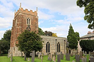
Hockerton is a village and civil parish in Nottinghamshire, England. It is 2 miles from the town of Southwell on the A617 between Newark and Mansfield. Fewer than 60 houses are situated around the church, the Spread Eagle pub and village hall. The population at the 2011 census was 146, increasing to 183 at the 2021 census. The local properties range from the carbon neutral housing of the Hockerton Housing Project to converted barns, 1960s and 1970s housing together with much older houses and a 19th-century Rectory. The parish church of St Nicholas is Norman with an aisleless nave and a 14th-century chancel.

Misterton is a village and civil parish in the Bassetlaw district of Nottinghamshire, England. The parish population at the 2011 census was 2,140, and has risen to 2,191 residents in the 2021 census.

Elkesley is a village in Nottinghamshire, England. According to the 2001 census it had a population of 805, increasing to 822 at the 2011 Census, and 852 in 2021. It is located 6 miles south of Retford.
Hawksworth is an English conservation village and civil parish in the Rushcliffe borough of Nottinghamshire. It lies 10 miles (16 km) south of Newark-on-Trent, adjacent to the villages of Flintham, Sibthorpe, Thoroton, Scarrington and Screveton.

Screveton is an English civil parish and village in the Rushcliffe borough of Nottinghamshire, with 191 inhabitants at the 2011 census. Screveton singularly reported 164 residents at the 2021 census. It was formerly in Bingham Rural District and before 1894 in Bingham Wapentake. It is adjacent to Kneeton, Flintham, Hawksworth, Scarrington, Little Green and Car Colston.
Scarrington is an English civil parish and small village in the Rushcliffe borough of Nottinghamshire, adjacent to Bingham, Car Colston, Hawksworth, Orston and Aslockton. Its 968 acres had a population in the 2011 census of 183, falling to 167 at the 2021 census. It lies at Ordnance Survey grid reference SK7341 in the undulating farmland of the Vale of Belvoir, some 2 miles (3.2 km) from the town of Bingham and from a stretch of the Roman Fosse Way (A46) between Newark and Leicester. It is skirted by the A52 road between Nottingham and Grantham.

Kersall is a hamlet and civil parish within the Newark and Sherwood district of central Nottinghamshire, England.


