
Newark and Sherwood is a local government district in Nottinghamshire, England. It is the largest district by area in the county. The council is based in Newark-on-Trent, the area's largest town. The district also includes the towns of Southwell and Ollerton along with a large rural area containing many villages. Much of the district lies within the ancient Sherwood Forest and there are also extensive forestry plantations in the area.

Aslockton is an English village and civil parish 12 miles (19 km) east of Nottingham and 2 miles (3.2 km) east of Bingham, on the north bank of the River Smite opposite Whatton-in-the-Vale. The parish is also adjacent to Scarrington, Thoroton and Orston and within the Rushcliffe borough of Nottinghamshire. The population was recorded as 974 in the 2011 census, doubling to 1,937 at the 2021 census.

Southwell is a minster and market town, and a civil parish, in the district of Newark and Sherwood in Nottinghamshire, England. It is home to the grade-I listed Southwell Minster, the cathedral of the Anglican Diocese of Southwell and Nottingham. The population of the town was recorded at 7,491 in the 2021 census.
Lowdham is a village and civil parish in the Newark and Sherwood district of Nottinghamshire between Nottingham and Southwell. According to the 2021 census, it had a population of 3,247. Two main roads slicing through the village are the A6097 south-east to north-west and the A612 between Nottingham and Southwell.
Bilsthorpe is a village and civil parish in the Newark and Sherwood district of Nottinghamshire, England. According to the 2001 census it had a population of 3,076, increasing to 3,375 at the 2011 census, and dropping slightly to 3,365 at the 2021 census. It is located near the junction of the A614 and A617, around 5 miles south of Ollerton, 9 miles east of Mansfield and 6 miles north-west of Southwell.

Thurgarton is a small village in rural Nottinghamshire, England. The village is close to Southwell, and Newark-on-Trent and still within commuting distance to Nottingham. It is served by Thurgarton railway station. According to the 2001 census it had a population of 412, increasing to 440 at the 2011 census and marginally to 445 at the 2021 census.

Elston is a village and civil parish in the Newark and Sherwood district, in Nottinghamshire, England, to the south-west of Newark, 0.5 mi (800 m) from the A46 Fosse Way. The population of the civil parish taken at the 2011 census was 631, increasing to 697 at the 2021 census. It lies between the rivers Trent and Devon, with the village "set amongst trees and farmland less than a mile from the A46.... Newark is five miles to the north, with... Lincoln and Nottingham some 18 miles north and south-west respectively."

Rainworth is a village in the ceremonial county of Nottinghamshire in the East Midlands of England. It is split between the local government districts of Newark and Sherwood and Mansfield. To the north of Rainworth is the village of Clipstone and to the east are the villages of Bilsthorpe and Farnsfield. Mansfield lies two miles to the west and the village of Blidworth is a mile to the south.

Fiskerton is a village and former civil parish, now in the parish of Fiskerton cum Morton, in the Newark and Sherwood district, in the county of Nottinghamshire, England. It is on the west bank of the River Trent about 3 miles southeast of Southwell. The waterfront is home to million-pound residential properties, previously residences of merchants and businessmen who commuted in the 1800s to nearby Nottingham by rail from Fiskerton Station. In 1881 the parish had a population of 283.

Oxton is a village in Nottinghamshire, England, with 568 residents at the 2011 census, falling marginally to 566 at the 2021 census. It is located 5 miles (8 km) west of Southwell, 5 miles (8 km) north of Lowdham, 10 miles (16 km) north-east of Nottingham and 2 miles (3 km) north-east of Calverton, and lies on the B6386, and is very close to the A6097 trunk road.

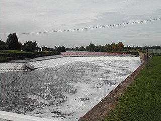
Rolleston is a small village and civil parish in Nottinghamshire by the River Greet, a few miles from Southwell not far from the Trent and about 5 miles (8.0 km) southwest of Newark. The population of the civil parish at the 2011 census was 312, increasing to 342 at the 2021 census. It has a church dedicated to the Holy Trinity. It lies close to the railway line between Nottingham and Lincoln with a station serving the village and Southwell as well as the nearby Southwell Racecourse.

Caunton is a village and civil parish in the Newark and Sherwood district of Nottinghamshire on the A616, six miles (9.7 km) north-west of Newark-on-Trent, in the NG23 postcode. The population of the civil parish at the 2011 census was 483, and this increased to 508 at the 2021 census.

Eakring is a village and civil parish in the Newark and Sherwood district of Nottinghamshire, England. Its population at the 2011 census was 419, and this increased to 440 residents for the 2021 census. There was sizeable oil production there in the mid-20th century.

Farnsfield is a large village and civil parish in Nottinghamshire in Sherwood Forest. It is in the local government district of Newark and Sherwood. The population of the civil parish as at the United Kingdom Census 2001 was 2,681, increasing in the 2011 census to 2,731, and 3,216 at the 2021 census.

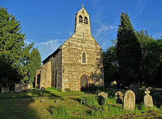
Walesby is a village and civil parish in Nottinghamshire, England. At the time of the 2001 census it had a population of 1,255 people, increasing slightly to 1,266 at the 2011 census, and dropping to 1,218 at the 2021 census. It is located 16 miles (26 km) north of Newark. The parish church of St Edmund is Perpendicular in style.

Coddington is an English village and civil parish in Nottinghamshire, 3 miles (4.8 km) east of Newark-on-Trent. According to the 2001 census it had a population of 972, which increased to 1,684 at the 2011 Census and to 1,538 at the 2021 census.
Edingley is a village in the Newark and Sherwood district of Nottinghamshire, England. According to the 2001 census it had a population of 390, increasing to 443 at the 2011 census, and falling to 401 at the 2021 census. It is located 3 miles north-west of Southwell.

Halloughton is a hamlet and civil parish in Nottinghamshire, England, 9 miles west of Newark-on-Trent. It lies in the district of Newark and Sherwood. Most of the property there was owned by the Church Commissioners until 1952. The resident population of the parish was 65 at the 2021 census.

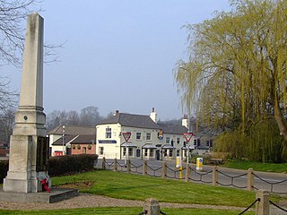
Staunton is a small village and civil parish in the Newark and Sherwood district of Nottinghamshire, England. It takes its name from the Vale of Belvoir and shares it with the local Staunton family, which has resided in the area since the Norman Conquest and possibly before, making them one of the few English families still resident on their estate.
Fiskerton cum Morton is a civil parish in the Newark and Sherwood district, within the county of Nottinghamshire, England. The overall area had a population of 803 at the 2021 census. The parish lies in the south east of the county. It is 112 miles north of London, 12 miles north east of the city of Nottingham, 5 miles west of the town of Newark-on-Trent and 21⁄2 miles south east of the town of Southwell. The parish lies along the bank of the River Trent and is primarily a commuter residential area to both Nottingham and Newark.


