Bury was a rural district in Lancashire, England from its establishment in 1894 under the Local Government Act 1894, until its abolition in 1933. The district consisted of a number of rural civil parishes near Bury, but did not include Bury itself. It was a successor to the Bury Rural Sanitary District.
Kettering was a rural district in Northamptonshire in England from 1894 to 1974.
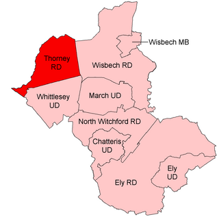
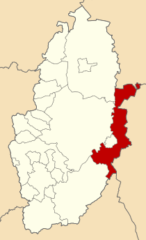
Thorney was a rural district in England from 1894 to 1974, situated to the east of Peterborough.
Spalding was a rural district in Holland in Lincolnshire, England from 1894 to 1974.
North Kesteven was a rural district in Kesteven, Lincolnshire from 1931 to 1974.
Claypole was a rural district in Lincolnshire, Parts of Kesteven from 1894 to 1931. It was formed under the Local Government Act 1894 from that part of the Newark-on-Trent rural sanitary district which was in Kesteven.
East Kesteven was a rural district in Lincolnshire, Parts of Kesteven from 1931 to 1974. It was formed under a County Review Order, by the merger of most of the Sleaford Rural District and the parish of Haceby from Grantham Rural District.
Bowland was a rural district in the West Riding of Yorkshire from 1894 to 1974. It was named after the Forest of Bowland, which it included.
Aethwy was a rural district in the administrative county of Anglesey, Wales, from 1894 to 1974.
Northampton was a rural district in Northamptonshire, England from 1894 to 1974.
Southwell was a rural district in Nottinghamshire, England from 1894 to 1974.
East Retford was a rural district in Nottinghamshire, England from 1894 to 1974.
Misterton was a rural district in Nottinghamshire, England from 1894 to 1935.

Bingham was a rural district in Nottinghamshire, England from 1894 to 1974.
Skegby was a rural district in Nottinghamshire, England from 1894 to 1935.

Blackwell was a rural district in Derbyshire, England from 1894 to 1974. It was created under the Local Government Act 1894 based on that part of the Mansfield rural sanitary district which was in Derbyshire.
Culham was a rural district in Oxfordshire, England from 1894 to 1932. It was formed under the Local Government Act 1894 from the part of the Abingdon Rural Sanitary District in the administrative county of Oxfordshire. The remainder of the sanitary district, in the administrative county of Berkshire, became Abingdon Rural District. The rural district council continued to be based at Abingdon, holding meetings in the workhouse of the poor law union.
Gainsborough was rural district in Lincolnshire, Parts of Lindsey from 1894 to 1974.

Caistor was a rural district in Lincolnshire, Parts of Lindsey from 1894 to 1974.
Cannock was a rural district in Staffordshire, England from 1894 to 1974.