Norwell, Nottinghamshire

Last updated

Norwell
St. Laurence, Norwell - geograph.org.uk - 124518.jpg
Nottinghamshire UK location map.svg
Red pog.svg
Norwell
Location within Nottinghamshire
Population490  [1]
OS grid reference SK7761
District
Shire county
Region
Country England
Sovereign state United Kingdom
Post town Newark
Postcode district NG23
Dialling code 01636
Police Nottinghamshire
Fire Nottinghamshire
Ambulance East Midlands
UK Parliament
List of places
UK
England
Nottinghamshire
53°08′50″N0°50′55″W / 53.1472°N 0.8486°W / 53.1472; -0.8486

Norwell is a village and parish about 6 miles (9.7 km) from Newark-on-Trent, in central Nottinghamshire, England. The population (including Norwell Woodhouse) at the 2011 census was 490. It is close to the border with Lincolnshire and the River Trent, and lies approximately 1.5 miles (2.4 km) from the A1 road and 1 mile (1.6 km) from the East Coast Main Line.

Contents

History

[2]

Early history

"Nortwelle" [3] is mentioned in Domesday Book (1086); it had a church, a priest and a watermill. The parish consists of Norwell, Norwell Woodhouse, and the now deserted village of Willoughby. For nearly a thousand years the parish of Norwell was owned by the church. Rents from land and houses were used to finance three canons (or prebendaries) of Southwell. The canons were the principal landlords and lived in moated manor houses: Overhall, Palishall and Tertia Pars. In the Middle Ages some prebendaries were national figures, such as Robert de Wodehouse (died 1346) who became treasurer of England.

Farming

In other respects Norwell was a typical farming community. Traces of the medieval open fields, with their ridge and furrow, may still be seen. Major changes followed parliamentary enclosure (1832) when the land was divided into small fields. Many small farms, possibly 28, were established, some in the village centre and others in outlying fields. Today there are a few large farms and no working farms in the village centre. Some old farmyards in the village like Church, Willoughby and Hill farms have been developed for new homes.

Self-sufficiency

19th century Norwell was almost self-sufficient. Blacksmiths, wheelwrights, stonemasons, and builders were often grouped together in yards leading off the main street. There were two windmills, two steam mills and a watermill. For a time Norwell had its own brickworks. Personal needs were met by General stores, bakers and butchers, shoemakers and a tailor. There were at least three public houses; The Black Horse, The Crown (later The Elephant and Castle) and The Plough. Norwell has had a school since 1727.

Buildings

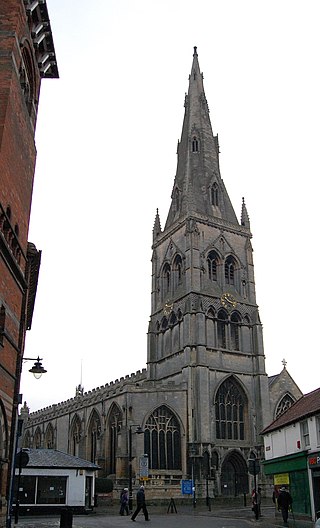
The medieval church of St Laurence is Grade 1 listed and has features from the 12th to the 20th century. Almost all of the buildings are of red brick with pantiles. There are many timber framed buildings originally with mud and stud between the timbers. Most are now entirely encased in brick but the timber can still be seen internally. There are a few striking 19th century houses, most of which were built by Henry Clipsham, the Norwell builder who also restored the Church. A windmill and distinctive circular pinfold can still be seen.

Norwell now

The population of the parish is about 450, much as it was around 1250 and 1700. It reached its peak in the 1860s when it was nearly 800.[ citation needed ]

Norwell Buildings

[4] [5] [6] [7]

St. Laurence Church

Brief history

The first church in Norwell was almost certainly a wooden one, probably erected as a chapel attached to an Anglo-Saxon manor house standing on or near where a later moated manor house was built, immediately to the south of the present church. This may have been the church, with its priest, mentioned in Domesday, but no traces of that chapel or church remain. Shortly after 1100 it was certainly replaced by a small rectangular building like that surviving at Littleborough, Nottinghamshire. Fragmented masonry associated with this first stone church has been identified in the north aisle.

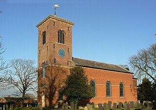
St Laurence's Church, Norwell Norwell church.jpg
St Laurence's Church, Norwell

During the 12th and 13th centuries other traces were lost through major work creating the church we now see. Around 1180–1200, the south aisle was added and the south door moved to its present position. A tower with three storeys was built shortly after 1200 and by 1250 the north aisle was added. A further expansion took place around 1300, partly paid for by a legacy from Mr John Clarell, prebendary of Overhall (d.1295). The north and south transepts were added, the Chancel lengthened and, a few years later, the south porch built. Finally between about 1450 and 1500, the nave was heightened with a clerestory (a row of flat-headed windows) inserted, the transepts and Chancel were re-roofed and a fourth storey with battlements an gargoyles added to the tower. The 19th century, largely sympathetic, restoration (Chancel, 1857-8, rest of church, 1872-5) by Ewan Christian faithfully preserves St Laurence's medieval appearance. The only major structural change was that Christian restored the Chancel to its 13th century form by removing the low pitched roof that was part of the 15th century refurbishment.

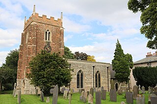
St Laurence's Church, Norwell St.Laurence's church nave - geograph.org.uk - 263828.jpg
St Laurence's Church, Norwell

Evidence from the church shows the wide variety of stone available in medieval Norwell. Much of the building is constructed in skerry, a form of pale grey sandstone, quarried locally at Tuxford, Laxton, Kneesall and Maplebeck. Magnesium limestone was brought from Mansfield and other limestone came from Ancaster in Lincolnshire, whilst local lias from Collingham and a light porous tufa, which outcrops in The Beck between Norwell and Caunton, has been identified. For high-quality monuments like tombs and effigies stone was sometimes imported over much longer distances like the Purbeck marble and Caen stone also present.

Methodist Chapel

The Primitive Methodist Chapel was built on land donated by Revd W.Sturtevant in 1827. In 1843 this chapel was bought by the Wesleyans, who re-opened it on 6 November. This flourished and was enlarged in 1909, with a school room built by Henry Clipsham & Sons at a cost of £337. It became a private house in 1991.

Norwell Schools

Three school buildings still stand in School Lane. The charity school, a Grade II listed building, has been sold, thoroughly restored to maintain many original features and is in private ownership. Since 1966 the Victorian School has been used as a youth centre and, currently, by Norwell scouts, still fulfilling the original charity requirement that it was for the benefit of the young of Norwell. It is showing its age and will require restoration work to keep it in good order. The modern school continues to change and extra rooms have been added in response to evolving requirements for the education of young children.

The Charity School

The first mention of a school in Norwell is in a grant by Thomas Sturtevent of Palishall in 1727 when he gave 4 acres of land at Holme to the Trustees of the Charity School of Norwell on condition that they pay £3 per year out of the rents thereof as a yearly stipend for his trouble in teaching six children elected by the trustees. This has often been taken to mean that the school itself was founded in 1727. However, the wording implies that the school was already set up with a schoolmaster in post. If so it was probably a private school beyond the means of poorer inhabitants, hence Sturtevent's endowment for six children to be taught.
The architectural style of the building, particularly the mannerist doorway, supports the idea that it may have been built by 1700 or soon afterwards. In any event the school was definitely operational in 1727
The school building as it exists today is an L-shape. On the ground floor there were two rooms. This would have made it possible for two classes to be taught, probably with the master in one room and his wife, the mistress, teaching in the other. Three rooms above the schoolrooms were probably reached by an outside staircase. The upper rooms may have been used as a dormitory for a small number of pupils, although there is no record of pupils from any distance attending the school.
The wing running northwards formed the living accommodation for the master and his wife. This was added towards the end of the 18th century. The school was replaced in 1872 by The National School following legislation for full-time education.

The Victorian School

The Trustees [of The Charity School] met in spring 1870 to consider the future of the school which was both small and in a poor state of repair. They proposed that alterations should be put in hand. Speaker [of the House of Commons] Denison suggested that it would be better to provide a completely new school and he offered to find half the cost whatever it might be. This generous offer was sufficient to convince the other trustees. An architect was appointed to draw up plans for a new school for 120 pupils.
It was agreed to spend £500 on the new school so long as the money for it could be raised. The site chosen for this new building was on land adjoining the existing school. An additional piece of land fronting School Lane was conveyed by the Ecclesiastical Commissioners to the vicar and churchwardens as trustees.
The plans for the new school are most beautifully executed. The exterior could almost be that of a typical Victorian church with Gothic windows and fine tracery. It was to be made of red brick with Ancaster stone dressings. The asymmetry of the South elevation is a compromise between a central door and a fireplace and chimney also as near to the centre as possible. The interior is equally traditional; there is just one large room with a very high roof. The design suggests that there were three sections to the room. The school log book refers to a gallery which appears to have been at the west end.
Henry Clipsham, the builder, was on hand and available. He had moved to Norwell in 1857 for the restoration of St Laurence's and had set up his business, particularly specialising in building vicarages and schools. Work commenced in 1871.
There were great celebrations when the first stone was laid. The church bells were rung and the Union Jack flew on the church tower. A church service was followed by a procession to the school with everyone singing Onward Christian Soldiers. Placed underneath the first stone was a bottle containing a parchment with the wording:
"The corner stone of this school was laid on Easter Monday, 10 April 1871 by the Rt. Hon. J.E.Denison. M.P, Speaker of the House of Commons. Trustees: Evelyn Denison, 1st Viscount Ossington |Rt. Hon. J.E.Denison, M.P., Ossington, John Vere Esq. Carlton on Trent, Rev. James Maxfield, Vicar of Norwell with Carlton, Rev. Samuel Reynolds Hole, Caunton Manor, Joseph Templeman, South Drain House, Joseph Curtis, Norwell, George Esam, South Field. Principle contributors, Rt. Hon. the Speaker, £200, Ecclesiastical Commissioners for the Church of England £200, Educational department £100. William Bolton, Schoolmaster, Hannah Bolton, Schoolmistress. Henry Clipsham, Builder."
The ceremony was followed by tea, sports and games, and finally a magic lantern show by Mr Bolton.
By the late 1890s the building was no longer large enough, and there were problems with teaching infants and the older children in the same room. Inspectors complained that the accommodation was inadequate. In September 1893 tenders were invited for building a new classroom, cloakrooms and outhouses. The school was enlarged at a cost of £230. The new room which provided accommodation for the infants was attached at right angles to the west end of the school partially obscuring the porch.
The school continued to be improved throughout the first half of the 20th century. The outside offices were a constant source of displeasure to pupils and inspectors alike. In 1905 an official visitor commented that the offices are in an unsatisfactory state. They should be cleaned out regularly – at least once a fortnight and once a week in summer. In June 1907 one of His Majesty's Inspectors reported The school is without a lavatory. Clearly these words were heeded as the Head Teacher wrote in October, presumably with some relief, The school has been supplied with towels, soap, and a water-can for use with the new lavatory"". The school must have felt truly modernised in 1946 when electric light was installed!
Finally it was decided in1965 that a new school building was needed and nearly a century of education in the Victorian School drew to a close.
In December 2018 the building was offered for sale by the Trustee’s and sold in 2019 with permission having been granted for change of use to a private dwelling.

The Modern School

In the middle of the 20th century yet more changes were taking place in education. Elementary schools for pupils of 5 to 14, with just a few taking the scholarship examination and going on to grammar schools or technical schools, were replaced in Nottinghamshire by primary schools for 5 to 11-year olds and secondary schools for those over 11. The school leaving age was also raised to 15. At primary schools children were taught in smaller groups by their own teacher. The arrangement of the rooms in the Victorian school did not adapt well to this type of teaching.
There were problems with heating and ventilation. The Local Education Authority agreed to provide a new school serving Norwell, Norwell Woodhouse, Ossington, Moorhouse and part of Carlton on Trent. Building started on the new school in March 1965 on a site in School Lane opposite the Victorian School on land acquired by the LocalAuthority and the Diocese. The construction of it, too, was typical of its time. It was built in the C.L.A.S.P. System by Messrs Ashley of Mansfield Woodhouse.
It is best described by using the words on the leaflet produced for the official opening ceremony on Friday, 4 November 1966, by Lt. Col. W M E Denison:
"The school, which is designed for 70 pupils, has three classrooms grouped around a small assembly hall. The hall is separated from one of the classrooms by a partition which can be folded back to give extra space when required. Each classroom has its own toilet and cloakroom facilities, and an outside door opening into a small lobby, useful for growing plants and keeping pets. Storage spaces for chairs and physical education apparatus are incorporated into the hall which is also used for dining and has a modern kitchen adjoining it. A staffroom completes the accommodation."
How different from the Victorian school! The toilet facilities must have delighted those familiar with the provision in their previous school. The design for 70 pupils reflects the changing population in the area; not just a fall in population but in the structure of families with a smaller number of children.
Norwell School has had a relationship with Ossington over the years. Speaker Denison, as well as being much involved in the building of the Victorian school in Norwell also established a school in Ossington in 1826. In 1941 this school was closed and demolished to make way for an RAF airfield (RAF Ossington), and Ossington pupils and teachers were transferred to Norwell. With these connections it was only fitting that as Speaker Denison had presided over the opening of the Victorian school in 1871 so his great nephew should do the same in 1966.

Material is reproduced with permission of Norwell Parish Heritage Group.

The Pinfold

Norwell Pinfold Norwellpinfold 1.jpg
Norwell Pinfold

The village pinfold or pound is located on Bathley Lane (west side) close to its junction with Main Street and Woodhouse Road. The 18th century circular structure is of brick with half round ashlar copings with a pair of square gate pillars with ashlar capitals. The wooden gate is 20th century. The pinfold is approximately 10m (33') in diameter and is reputedly the largest round pinfold in the county (Nottinghamshire).

The structure is Grade II listed by Historic England (listing number 1045950). [8]

An attached plaque carries the inscription:

PINFOLD
BUILT CIRCA 1830
TO REPLACE AN EARLIER
WOODEN PINFOLD USED TO
PEN STRAY ANIMALS WHICH
COULD THEN BE RECLAIMED
ON PAYMENT OF A FINE
TO THE PINDER
[Signed] NORWELL PARISH COUNCIL

The Tower Mill/Steam Mill

Tower Mill, Main St, Norwell Norwell Mill-geograph.org-2236128.jpg
Tower Mill, Main St, Norwell

A date stone suggests that Norwell's tower windmill, in Main Street, was built in 1852. It is a five-storey brick tower, standing 43' (13.5m) high to the curb, with Yorkshire sliding windows. The cap was a typical ogee shape and probably originally covered in iron plates. There were three pairs of millstones on the first floor, overdriven by a wooden upright shaft in wooden bearings. The stones could be disengaged by means of elm glut boxes (glut box timbers have a slot cut in them to allow the top of the quant (the vertical shaft) to be removed, enabling the stone nuts (pinions), and hence the millstone to be disengaged from the great spur wheel).

The mill had four sails which used the Cubitt patent system of a striking lever to the rear so that the shutters could be furled by only removing the weight from the chain to the striking lever. It was winded by a fantail which served to turn the main sails of the mill automatically into the wind.

On the ground floor there was a hurst frame supporting two pairs of stones which were driven by a layshaft from a steam engine and later a mobile oil engine. A layshaft to the mill, the bearing stone block and cast iron boxes for the bearings were present in 1977.

A 1910 description, which was part of a national survey to establish a new property tax, states that the Mill House was in good repair, with two living rooms, kitchen, dairy, and three bedrooms. Outside there was a coal house, an outside privy, a stable (with two stalls), chaff house, cart shed, bake house, engine shed (wood, iron), and a mill powered by steam and wind in good repair. The whole property was assessed at a market value of £480 of which buildings accounted for £420.

Plans to restore the Tower Mill have failed and Planning permission has been granted to convert the building into a dwelling integrated into the existing 1970’s bungalow alongside.

Transport

Road

Norwell roads including Main Street, Carlton Road, Ossington Road, Bathley Lane and Woodhouse Road are unclassified. The speed limit through the village is 30 mph with an advisory 20 mph along part of Main Street due to the proximity of the school.

The A1 Trunk Road (Cromwell Bypass) passes the parish approximately 1.5 miles to the east of Norwell. Although not within the parish it is of interest that Cromwell Bypass was the location of highly collaborative trials of the slip-form paver in 1964/65. [9] The first such machine to be brought into the UK was used to trial the laying of unreinforced and reinforced concrete carriageways with dowelled contraction and expansion joints. The surface has now been rebuilt using tarmac (asphalt concrete). The A616 road passes approximately 2 miles to the west of Norwell.

Rail

The East Coast Main Line crosses the east of the parish in an approximately north/south direction, passing approximately 1 mile to the east of the village itself.

The nearest railway stations are in Newark-on-Trent, seven miles to the south-east. Newark North Gate is located on the East Coast Main Line, between London King's Cross and Edinburgh Waverley, and Newark Castle is located on the Nottingham to Lincoln line.

See also

Related Research Articles

<span class="mw-page-title-main">Pleasley</span> Human settlement in England

Pleasley is a village and civil parish with parts in both Derbyshire and Nottinghamshire. It lies between Chesterfield and Mansfield, 5 miles (8 km) south east of Bolsover, Derbyshire, England and 2.5 miles (4 km) north west of Mansfield, Nottinghamshire. The River Meden, which forms the county boundary in this area, runs through the village.

<span class="mw-page-title-main">Retford</span> Market town in Nottinghamshire, England

Retford, also known as East Retford, is a market town in the Bassetlaw District in Nottinghamshire, England. It lies on the River Idle and the Chesterfield Canal. Retford is 26 miles (42 km) east of Sheffield, 23 miles (37 km) west of Lincoln and 31 miles (50 km) north-east of Nottingham. The population at the 2021 census was 23,740. Retford railway station is on the East Coast Main Line and the town is bypassed by the A1 road.

<span class="mw-page-title-main">Dronfield</span> Human settlement in England

Dronfield is a town in North East Derbyshire, England, which includes Dronfield Woodhouse and Coal Aston. It lies in the valley of the River Drone between Chesterfield and Sheffield. The Peak District National Park is three miles (4.8 km) to the west. The name comes from the Old English Dranfleld, probably meaning an open land infested with drone bees.

<span class="mw-page-title-main">Meanwood</span> Suburb of Leeds in West Yorkshire, England

Meanwood is a suburb and former village in north-west Leeds, West Yorkshire, England.

<span class="mw-page-title-main">Southwick, Wiltshire</span> Human settlement in England

Southwick is a semi-rural village and civil parish 3 miles (4.8 km) south-west of the county town of Trowbridge, Wiltshire, England. It is separated from the south-west fringe of Trowbridge only by the Southwick Country Park, which consists of 380 acres (150 ha) of open fields. The majority of the village lies south of the A361, which runs through the village, linking Trowbridge with Frome.

<span class="mw-page-title-main">Walton-on-the-Hill</span> Human settlement in England

Walton-on-the-Hill, Surrey, is a village in England midway between the market towns of Reigate and Epsom. The village is a dispersed cluster on the North Downs centred less than one mile inside of the M25 motorway. The village hosts the Walton Heath Golf Club, whose former members include King Edward VIII, Winston Churchill and David Lloyd George.

<span class="mw-page-title-main">South Luffenham</span> Human settlement in England

South Luffenham is a village in the county of Rutland in the East Midlands of England. The population of the civil parish was 470 in 2021 increasing from 455 at the 2011 census.

<span class="mw-page-title-main">Widmerpool</span> Human settlement in England

Widmerpool is a village and civil parish in Nottinghamshire, about 10 miles south-south-east of Nottingham and some 7.5 miles north-east of Loughborough. It is one of Nottinghamshire's oldest settlements and is just over a mile west of the A46. Extensive dual carriageway road works along the A46 have now been completed. At the time of the 2001 census it had a population of 262, increasing to 339 at the 2011 census. Until the 1960s there had not been any building in the village for 100 years.

<span class="mw-page-title-main">Ossington</span> Village in Nottinghamshire, England

Ossington is a village in the county of Nottinghamshire, England 7 miles north of Newark-on-Trent. It is in the civil parish of Ossington, but for census purposes its population count is included with the civil parishes of Ompton and Laxton and Moorhouse. It was centred on Ossington Hall, the ancestral home of the Denison family, but the house was demolished in 1964 and all that remains are a few outbuildings and a private chapel that now serves the parish as Holy Rood Church, Ossington. This is a Grade I listed building, originally 12th century and rebuilt in 1782–1783 by the architect John Carr, with minor 19th-century alterations and additions. It includes earlier monuments and stained glass. There is a barrel organ built by Thomas Robson in 1840.

<span class="mw-page-title-main">Kinoulton</span> Human settlement in England

Kinoulton is a village, civil parish and ecclesiastical parish in Nottinghamshire, England, 10 miles (16 km) south east of the city of Nottingham. It is probably Saxon in origin, and once had a brick-making industry. It is close to the A46 road, and has a population of about 1,000.

<span class="mw-page-title-main">St Laurence's Church, Norwell</span> Church

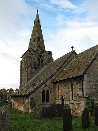
St. Laurence Church, Norwell is a parish church in the Church of England in Norwell, Nottinghamshire.

<span class="mw-page-title-main">Holy Rood Church, Ossington</span> Church

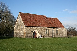
Holy Rood Church, Ossington is a parish church in the Church of England in Ossington, Nottinghamshire.

<span class="mw-page-title-main">St Giles' Church, Cromwell</span> Church

St. Giles' Church, Cromwell is a parish church in the Church of England in Cromwell, Nottinghamshire.

<span class="mw-page-title-main">Wainfleet St Mary</span> Village and civil parish in the East Lindsey district of Lincolnshire, England

Wainfleet St Mary is a village and civil parish in the East Lindsey district of Lincolnshire, England. It is situated directly south of Wainfleet All Saints on the A52 road, 5 miles (8 km) south-west from Skegness and 14 miles (23 km) north-east from Boston. The 2001 Census recorded a population of 1,106, reducing to 1,025 at the 2011 census. It includes the hamlet of Wainfleet Bank.

<span class="mw-page-title-main">Warsop</span> Civil parish in England

Warsop is a town and civil parish in Mansfield District, Nottinghamshire, England, on the outskirts of the remnants of Sherwood Forest. At the 2021 census the population was 12,644 resaidents, including Church Warsop, Meden Vale, Sookholme and Spion Kop.

<span class="mw-page-title-main">Moorhouse Chantry Chapel</span> Church in Nottinghamshire, England

Moorhouse Chantry Chapel is a Grade II* listed Church of England chapel in the Diocese of Southwell and Nottingham at Moorhouse, within the Laxton and Moorhouse civil parish, Nottinghamshire.

<span class="mw-page-title-main">Norwell Woodhouse</span> Human settlement in England

Norwell Woodhouse is a small village and former civil parish, now in the parish of Norwell, in the Newark and Sherwood district, in the county of Nottinghamshire, England. It is close to the villages of Caunton, Kneesall, Cromwell and Laxton and around 8 miles (13 km) from Newark-on-Trent. In 1931 the parish had a population of 69.

<span class="mw-page-title-main">Church of St Edmund, Mansfield Woodhouse</span> Church in Nottinghamshire, England

The Church of St Edmund is on Old Manor Road, Mansfield Woodhouse, Nottinghamshire, England. It is an active Church of England parish church in the deanery of Mansfield, the Archdeaconry of Newark, and the Southwell and Nottingham diocese. Its benefice has two churches, St Edmund’s is the main parish church, also the Church of St Chad, Pleasley Vale. The church is recorded in the National Heritage List for England as a designated Grade II* listed building.
<span class="mw-page-title-main">Moorhouse, Nottinghamshire</span> Human settlement in England

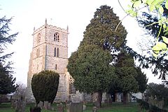
Moorhouse or Laxton Moorhouse is a hamlet within the Laxton and Moorhouse parish, in the Newark and Sherwood district of central Nottinghamshire, England.

References

  1. Norwell. "Neighbourhood Statistics". Office for National Statistics. Retrieved 19 January 2017.
  2. Norwell Parish Heritage Group (2007). Michael Jones (Series Editor). Norwell Heritage Trail. Norwell Parish Heritage Group.
  3. Ekwall, Eilert , The Concise Oxford Dictionary of English Place-Names. Oxford, Oxford University Press, 4th edition, 1960. p. 345. ISBN   0198691033 .
  4. Norwell Parish Heritage Group (2009). Michael Jones (Series Editor). Norwell Heritage Booklet 1 – Norwell Buildings. Norwell Parish Heritage Group. ISSN   2040-2406
  5. Norwell Parish Heritage Group (2013). Michael Jones (Series Editor). Norwell Heritage Booklet 7 – Norwell Church & Chapel. Norwell Parish Heritage Group. ISSN   2040-2406
  6. Norwell Parish Heritage Group (2013). Michael Jones (Series Editor). Norwell Heritage Booklet 4 – Norwell Schools. Norwell Parish Heritage Group. ISSN   2040-2406
  7. Norwell Parish Heritage Group (2009). Michael Jones (Series Editor). Norwell Heritage Booklet 3 – Norwell Mills. Norwell Parish Heritage Group. ISSN   2040-2406
  8. Historic England. "[Norwell] Village Pound (1045950)". National Heritage List for England . Retrieved 24 January 2017.
  9. The National Archives. "Experimental road layouts: concrete roads construction; Cromwell Bypass (A1): slip form paver trials" . Retrieved 5 February 2017.

Commons-logo.svg Media related to Norwell, Nottinghamshire at Wikimedia Commons

Community website http://norwell-online.org.uk