A6079 road

Last updated

UK road A6079.svg
A6079
Border Counties Railway - geograph.org.uk - 1273025.jpg
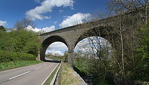
A6079 road looking north at a bridge of the Border Counties Railway near Chollerton
Route information
Length8 mi (13 km)
Major junctions
North endA68
Major intersectionsUK road A695.svg A695
UK road A68.svg A68
UK road A69.svg A69
South endHexham
Location
Country United Kingdom
Road network
UK road A6078.svg A6078 UK road A6085.svg A6085

The A6079 is a road in Northumberland, northern England, that runs eight miles (13 km) from Hexham to the A68 road.[ citation needed ]

Route

The road begins in Hexham before overlapping the A69 for 0.7 miles, then passing the villages of Acomb and Wall prior to meeting the B6318 road just to the south of Chollerford – unusually, traffic on the A6079 must give way to the traffic on the B6318, despite the fact that "A"-roads are more important than "B"-roads. The A6079 continues through the village of Chollerton, and terminates at its junction with the A68 road to Edinburgh, nine miles (14 km) north-west of Corbridge.[ citation needed ]

Related Research Articles

<span class="mw-page-title-main">M45 motorway</span> Motorway in England

The M45 is a motorway in Northamptonshire and Warwickshire, England and is 7.9 miles (12.7 km) long. It runs between junction 17 of the M1 motorway south east of Rugby and a junction with the A45 road southwest of Rugby. It has one of the lowest traffic volumes of the United Kingdom motorway system.

<span class="mw-page-title-main">A68 road</span> Major road in the United Kingdom

The A68 is a major road in the United Kingdom, running from Darlington in England to the A720 in Edinburgh, the capital of Scotland. It crosses the Anglo-Scottish border at Carter Bar and is the only road to do so for some distance either way; the next major crossings are the A697 from Coldstream to Cornhill-on-Tweed in the east, and the A7 near Canonbie to the west.

<span class="mw-page-title-main">New England Highway</span> Highway in New South Wales and Queensland

New England Highway is an 883-kilometre (549 mi) long highway in Australia running from Yarraman, north of Toowoomba, Queensland, at its northern end to Hexham at Newcastle, New South Wales, at its southern end. It is part of Australia's National Highway system, and forms part of the inland route between Brisbane and Sydney.

<span class="mw-page-title-main">Acomb, Northumberland</span> Human settlement in England

Acomb is a village in the south of Northumberland, England. The population at the 2001 Census was 1,184 increasing to 1,268 at the 2011 Census. It is situated to the north of Hexham, not far from the junction of the A69 road and A6079 road. The name is Anglo-Saxon Old English acum, 'at the oak trees'. The traditional pronunciation of the name is "Yeckam".

<span class="mw-page-title-main">Chollerford</span> Human settlement in England

Chollerford is a village in Northumberland, England, approximately four miles north of Hexham on the B6318, the Military Road, not far from Hadrian's Wall. There is a roundabout in the village where the B6318 and B6320 roads meet and the traffic light-controlled Chollerford Bridge crosses the River North Tyne. Beside the river is The George Hotel.

<span class="mw-page-title-main">Chollerton</span> Human settlement in England

Chollerton is a village in Northumberland, England, on the A6079 road about six miles (10 km) to the north of Hexham, on the River North Tyne. Nearby villages include Low Brunton and Humshaugh. The village has a fine example of a mounting block standing at the churchyard gate.

<span class="mw-page-title-main">Hadrian's Wall Path</span> Long-distance footpath in the north of England

Hadrian's Wall Path is a long-distance footpath in the north of England, which became the 15th National Trail in 2003. It runs for 84 miles (135 km), from Wallsend on the east coast of England to Bowness-on-Solway on the west coast. For most of its length it is close to the remains of Hadrian's Wall, the defensive wall built by the Romans on the northern border of their empire. This is now recognised as part of the "Frontiers of the Roman Empire" World Heritage Site.

<span class="mw-page-title-main">Riding Mill</span> Human settlement in England

Riding Mill is a village near Hexham in Northumberland, England. It is part of the civil parish of Broomhaugh and Riding. It is served by Riding Mill railway station and by a frequent bus service on the route from Hexham to Newcastle.

<span class="mw-page-title-main">County Road 854 (Miami-Dade County, Florida)</span> Former state highway in Florida, United States

County Road 854, locally known as Ives Dairy Road, Dan Marino Boulevard, and Honey Hill Drive, is the unsigned designation for an east–west commuter road spanning 8.7 miles (14.0 km) across northern Miami-Dade County, which encompasses sections of North 199th Street, North 202nd Street, North 203rd Street, and North 205th Terrace. Its western terminus is an intersection with Red Road/Northwest 57th Avenue near Miami Lakes and Carol City, the eastern terminus is an intersection with Biscayne Boulevard in Aventura, a half block east of an overpass over West Dixie Highway that once served as part of the Dixie Highway and US 1.

<span class="mw-page-title-main">New York State Route 174</span> State highway in Onondaga County, New York, US

New York State Route 174 (NY 174) is a state highway in Onondaga County, located in Central New York, in the United States. The highway is 16.7 miles (26.9 km) long and passes through mostly rural regions. Route 174 begins at an intersection with NY 41 in Borodino, a hamlet of Spafford. It heads generally northward for most of its length, except for short distances in the villages of Marcellus and Camillus. The route ends at a junction with NY 5 west of Camillus, at the west end of the Route 5 Camillus bypass. Route 174 is located along a large mapped sedimentary bedrock unit, known as the Marcellus Formation. The formation is named for an outcrop found near the town of Marcellus, New York, during a geological survey in 1839.

<span class="mw-page-title-main">Greenhead, Northumberland</span> Human settlement in England

Greenhead is a village in Northumberland, England. The village is on the Military Road (B6318), about 17 miles (27 km) from Chollerford, 3 miles (5 km) from Haltwhistle and 9 miles (14 km) from Brampton, Cumbria along the A69 road. The A69 bypasses the village, but until the 1980s all vehicular traffic passed through it. The village lies just outside the Northumberland National Park, close to Hadrian's Wall. Just to the north of the village is the 12th-century Thirlwall Castle, recently restored and opened to the public. Nearby villages include Upper Denton and Haltwhistle.

<span class="mw-page-title-main">West Woodburn</span> Human settlement in England

West Woodburn is a village in north-western Northumberland, England. The 2001 census recorded a population of 492 in the parish of Corsenside, of which West Woodburn is the main settlement. The village is 15 miles (24 km) south of the border with Scotland and about 13 miles (21 km) north of Hexham.

<span class="mw-page-title-main">New York State Route 952Q</span>

New York State Route 952Q (NY 952Q) is an unsigned reference route designation for the portion of Walden Avenue outside of the Buffalo city limits in Erie County, New York, in the United States. The western terminus of the 14-mile (23 km) route is at the Buffalo city line in Cheektowaga, where Walden Avenue continues west toward downtown Buffalo. Its eastern terminus is at Genesee Street in Alden, where NY 33 and Genesee Street continue on the linear northeasterly path followed by Walden Avenue for most of its routing.

<span class="mw-page-title-main">A697 road</span> Road in Northumberland & southern Scotland

The A697 is a road that can be used an alternative to the A1 for those travelling between Scotland and England via the North East.

<span class="mw-page-title-main">Route 192 (Connecticut–Massachusetts)</span> Highway in Connecticut and Massachusetts

Route 192 is a 5.71-mile-long (9.19 km) state route in the U.S. states of Connecticut and Massachusetts, serving the southeastern suburbs of Springfield. It connects the Hazardville section of the town of Enfield, Connecticut, to the town center of Longmeadow, Massachusetts. The Massachusetts portion of the route is maintained by the town, as opposed to MassDOT.

Corsenside is one of the largest parishes in Northumberland, however the area is mainly a vast expanse of rolling hills and farmland, with three tiny villages: West Woodburn, East Woodburn and Ridsdale with about 600 inhabitants in total. The area runs alongside the A68 road about 17 miles (27 km) north of Corbridge. The A68 roughly follows the route of the old Roman 'Dere Street'. There are many historic points of interest in this area including the remains of the Roman Camp of Habitancum, Bell Knowe an Iron Age burial site, and the remains of Ridsdale Iron Works, which had its heyday in the Industrial Revolution.

<span class="mw-page-title-main">Whittle Dene</span> Reservoir in England, UK

Whittle Dene is 12 miles (19 km) west of Newcastle upon Tyne, England, straddling the B6318 Military Road, and is a complex of reservoirs and treatment works forming the last stage in the supply of drinking water to Newcastle upon Tyne and Gateshead.

<span class="mw-page-title-main">Styford Bridge</span> Bridge in Northumberland

Styford Bridge is a modern concrete bridge carrying the A68 road across the River Tyne east of Riding Mill, Northumberland, England and forms part of the A68 bypass of Corbridge.

<span class="mw-page-title-main">Milecastle 23</span> Milecastle in Northumberland, England, UK

Milecastle 23 (Stanley) was a milecastle of the Roman Hadrian's Wall. Its remains exist as a low, grass covered platform with traces of an external ditch (as Milecastle 25). It is located to the south of the B6318 Military Road around 1.5 kilometres (0.93 mi) west of its junction with the A68.

Brunton Bank Quarry is a disused quarry now designated as a Site of Special Scientific Interest (SSSI) in Northumberland, North East England. The quarry exposes a base layer of the Namurian Great Limestone stratigraphic unit, including the Chaetetes Band, the fossilised fauna within which is of current geological interest.

References

    Template:Attached KML/A6079 road
    KML is from Wikidata