A602 road

Last updated

UK road A602.svg
A602
Stevenage Road A602.jpg
Major junctions
Northwest end Hitchin
Major intersectionsA1(M)
A10
UK road A119.svg A119
UK road A1072.svg A1072
UK road A1155.svg A1155
UK road A505.svg A505
Southeast end Ware
Location
Country United Kingdom
Primary destinations Stevenage
Road network

The A602 is a road linking Hitchin in Hertfordshire, England, with A10 at Ware in Hertfordshire, via Stevenage.

Contents

The course of the road has changed significantly since the 1960s with the construction of several bypasses and relief roads.

In Hitchin, the road starts at a junction with the A505, and follows a relief road round the south of the town centre, before re-joining the course of the original route for 0.9 miles (1.4 km).

The village of Little Wymondley is bypassed by a dual carriageway route to the A1 junction at Corey's Mill.

In Stevenage, the road takes two courses through the town – the first is a concurrency with the A1 round the new town to the junction at Langley Sidings. The second is a route through the town itself, following closely the route of the old Great North Road. The two routes converge and form a northern bypass for the suburb of Broadwater (the old Hertford Road through Broadwater has been closed to motor vehicles since the 1990s, to prevent rat-running).

The next 3 km of road is the only remaining original piece of the route, travelling through the villages of Bragbury End and Hooks Cross. The next feature is a roundabout, and the road once again diverges from its original course and takes a left to bypass the village of Watton-at-Stone. At the eastern end of the Watton-at-Stone bypass (constructed in the late 1980s) it reaches another roundabout.

In the 1970s, the road continued from this point straight ahead down what is now the A119 to Hertford, and then travelled along the course of what is now the B1197 through Hertford Heath to Hoddesdon. With the opening of the A10 Hoddesdon and Ware bypass in the late 1970s, the A602 temporarily terminated at the A414 in Hertford. In 1987, with the opening of the Tonwell bypass, the road was completely re-routed along the course of the B1001 from Watton-at-Stone to meet the modern A10 at Ware. The B1001 itself remains for a short distance, linking the modern A10 with the old road in the town centre (now known as the A1170).

Future developments

A602 Corridor Improvements

A602 Corridor Improvements
A602development.png
LocationHertfordshire
ProposerHertfordshire County Council
Statusproposed
TypeRoad
Cost estimate (high)£15.8 million
Cost estimate (low)£14.3 million
Start dateSummer 2007
Geometry KML

Due to the old nature of the road it suffers from congestion, substandard structure and a high level of accidents. As such a series of developments along much of its stretch where proposed in the 2006-2011 Local Transport Plan. These comprise a number of different schemes but are put forward together under the collective title of 'A602 Corridor Improvements'. [1] The various schemes involve work on junctions, road re-alignment to make severe bends safer, structural maintenance and road safety schemes. It also considers the construction of a bypass at Hooks Cross but this remains in the early proposal stage. In 2006 the estimate cost of the whole strategy was given as between £14.3 and £15.8 million. Each individual scheme is intended to be brought forward as and when funding becomes available. [2] The section between Sacombe Pound and Watton-at-Stone gained planning permission for work to commence in summer 2007 [3] though work was never started, so all sections remain at the proposal stage.

Related Research Articles

Hertfordshire County of England

Hertfordshire is one of the home counties in southern England. It borders Bedfordshire and Cambridgeshire to the north, Essex to the east, Greater London to the south, and Buckinghamshire to the west. For government statistical purposes, it forms part of the East of England region.

Hoddesdon Town in Hertfordshire, England

Hoddesdon is a town in the Borough of Broxbourne, Hertfordshire, lying entirely within the London Metropolitan Area and Greater London Urban Area. The area is on the River Lea and the Lee Navigation along with the New River.

Stevenage Town and borough in Hertfordshire, England

Stevenage is a large town and borough in Hertfordshire, England, 29 miles (47 km) north of London. Stevenage is east of junctions 7 and 8 of the A1(M), between Letchworth Garden City to the north and Welwyn Garden City to the south. In 1946, Stevenage was designated the United Kingdom's first New Town under the New Towns Act.

East Hertfordshire Non-metropolitan district in England

East Hertfordshire is a local government district in Hertfordshire, England. Its council is based in Hertford, the county town of Hertfordshire. The largest town in the district is Bishop's Stortford, and the other main towns are Ware, Buntingford and Sawbridgeworth. At the 2011 Census, the population of the district was 137,687.

A10 road (England) Road in England

The A10 is a major road in England.

A414 road Major road in England

The A414 is a major road in England. It runs from the A41 at a junction west of Hemel Hempstead in Hertfordshire, through the town to junction 8 of the M1 motorway at Buncefield, and running parallel to the M1 until junction 7, heading south of St Albans, east through Hatfield, Hertford, then across the A10 and into Essex through Harlow, Chipping Ongar and Chelmsford before terminating at Maldon.

Stevenage (UK Parliament constituency) Parliamentary constituency in the United Kingdom, 1983 onwards

Stevenage is a constituency represented in the House of Commons of the UK Parliament since 2010 by Stephen McPartland, a Conservative.

Watton-at-Stone Human settlement in England

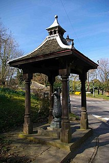
Watton-at-Stone is a village in the English county of Hertfordshire, situated midway between the towns of Stevenage and Hertford in the valley of the River Beane. The 2011 census showed a population of 2,272 living in 946 households. Watton-at-Stone is also a civil parish in East Hertfordshire District Council.

Hertford loop line Branch of the East Coast Main Line

The Hertford Line is a branch of the East Coast Main Line, part of the Northern City Line commuter route to London for Hertford and other Hertfordshire towns and an occasional diversion route for the main line. The line is part of the Network Rail Strategic Route 8, SRS 08.03 and is classified as a London and South East Commuter line.

Watton-at-Stone railway station Railway station in Hertfordshire, England

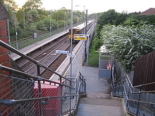
Watton-at-Stone railway station serves the village of Watton-at-Stone in Hertfordshire, England. It is 23 miles 72 chains down the line from London King's Cross on the Hertford Loop Line between Hertford North and Stevenage and is served by trains operated by Great Northern.

Great Northern route Suburban rail service in Great Britain

The Great Northern route is the name given to suburban rail services run on the southern end of Britain's East Coast Main Line and its associated branches. Services operate to or from London King's Cross and London Moorgate in London. Destinations include Hertford North, Welwyn Garden City, Stevenage, Peterborough, Cambridge, and King's Lynn. Services run through parts of Greater London, Hertfordshire, Bedfordshire, Cambridgeshire, and Norfolk.

A505 road

The A505 is an A-class road in England. It follows part of the route of the Icknield Way and the corresponding Icknield Way Path and runs from Leighton Buzzard, Bedfordshire to the A11, Cambridgeshire near Abington and Sawston. Being built in the East of England countryside, the majority of the road is flat, and some of the road is raised.

Hitchin (UK Parliament constituency) Parliamentary constituency in the United Kingdom, 1885–1983

Hitchin was a parliamentary constituency in Hertfordshire which returned one Member of Parliament (MP) to the House of Commons of the Parliament of the United Kingdom from 1885 until it was abolished for the 1983 general election.

Tonwell Human settlement in England

Tonwell is a small village in Bengeo Rural parish, Hertfordshire.

Hertfordshire County Football Association Governing body of association football in Hertfordshire

The Hertfordshire County Football Association, also simply known as Hertfordshire FA, is the governing body of football in the county of Hertfordshire, England. The Hertfordshire FA was founded accidentally in 1885 after the existing teams agreed to hold a meeting to discuss their position, and ended up affiliating.

Hitchin Rural District was a rural district in Hertfordshire, England from 1894 to 1974, covering an area in the north of the county.

Woodhall Park Historic house in Hertfordshire, England

Woodhall Park is a Grade I listed country house near Watton-at-Stone, Hertfordshire, England. The 18th century neo-classical building is set in a walled park in the Beane valley. It has been the home of Heath Mount School since the 1930s.

References

  1. "Section 12 – The five year implementation programme" (PDF). Hertfordshire County Council. Archived from the original (PDF) on 10 October 2008. Retrieved 10 December 2008.
  2. "A602 Corridor Improvements (A10 Ware to Hertford Rd, Stevenage)". Hertfordshire County Council . Retrieved 10 December 2008.[ permanent dead link ]
  3. "Notification of Planning Application received by Hertfordshire County Council" (PDF). Hertfordshire County Council. Archived from the original (PDF) on 27 September 2007. Retrieved 10 December 2008.

Coordinates: 51°52′23″N0°09′05″W / 51.8731°N 0.1513°W / 51.8731; -0.1513