
The Peak District is an upland area in central-northern England, at the southern end of the Pennines. Mostly in Derbyshire, it extends into Cheshire, Greater Manchester, Staffordshire, West Yorkshire and South Yorkshire. It is subdivided into the Dark Peak, moorland dominated by gritstone, and the White Peak, a limestone area with valleys and gorges. The Dark Peak forms an arc on the north, east and west of the district, and the White Peak covers central and southern areas. The highest point is Kinder Scout. Most of the area is within the Peak District National Park, a protected landscape designated in 1951.

Mam Tor is a 517 m (1,696 ft) hill near Castleton in the High Peak of Derbyshire, England. Its name means "mother hill", so called because frequent landslips on its eastern face have resulted in a multitude of "mini-hills" beneath it. These landslips, which are caused by unstable lower layers of shale, also give the hill its alternative name of Shivering Mountain.

Castleton is a village and civil parish in the High Peak district of Derbyshire, England, at the western end of the Hope Valley on the Peakshole Water, a tributary of the River Noe, between the Dark Peak to the north and the White Peak to the south. The population was 642 at the 2011 Census.

Hope is a village and civil parish in the Derbyshire Peak District, in England. The population at the 2011 Census was 864. It lies in the Hope Valley, at the point where Peakshole Water flows into the River Noe. To the north, Win Hill and Lose Hill stand either side of the Noe.

Hathersage is a village and civil parish in the Peak District in Derbyshire, England. It lies slightly to the north of the River Derwent, approximately 10 miles (16.1 km) south-west of Sheffield.

High Peak is a local government district with borough status in Derbyshire, England, covering a high moorland plateau in the Dark Peak area of the Peak District National Park. The district stretches from Holme Moss in the north to Sterndale Moor in the south, and from Hague Bar in the west to Bamford in the east. The population of the borough taken at the 2011 Census was 90,892. The borough is unusual in having two administrative centres for its council, High Peak Borough Council; the offices are in Buxton and Glossop. Other towns include Chapel-en-le-Frith, Hadfield, New Mills and Whaley Bridge.

The Dark Peak is the higher and wilder part of the Peak District in England, mostly forming the northern section but also extending south into its eastern and western margins. It is mainly in Derbyshire but parts are in Staffordshire, Cheshire, Greater Manchester, West Yorkshire and South Yorkshire.

The Hope Valley is a rural area centred on the village of Hope, Derbyshire, in the Peak District in the northern Midlands of England.

Sparrowpit is a small village between Chapel-en-le-Frith and Peak Forest in the High Peak area of the Peak District, Derbyshire, England.
The Manchester, Buxton, Matlock and Midland Junction Railway ran from a junction with the Midland Railway at Ambergate to Rowsley north of Matlock and thence to Buxton.

Chapel-en-le-Frith railway station serves the Peak District town of Chapel-en-le-Frith, Derbyshire, England. It is 20+1⁄2 miles south east of Manchester Piccadilly on the Buxton Line from Manchester. It was built in 1863 for the London & North Western Railway, on its line from Whaley Bridge to Buxton as an extension of the Stockport, Disley and Whaley Bridge Railway.

Snake Pass is a hill pass in the Derbyshire section of the Peak District, crossing the Pennines between Glossop and the Ladybower Reservoir at Ashopton. The road was engineered by Thomas Telford and opened in 1821. The pass carries the A57 road between Manchester and Sheffield, but it is no longer the main signposted route between those two cities, with traffic instead directed through the Woodhead Pass to the north.

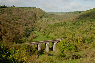
Padley Gorge is a deep but narrow valley in the Peak District, Derbyshire between the village of Grindleford and the A6187 road.

Hathersage Road is a road in Sheffield South Yorkshire, England and Derbyshire. It leads south-west from the suburb of Whirlow over the border between Hathersage and Sheffield, before becoming Sheffield Road at the point called Surprise View. The road begins at a bridge on the Limb Brook, the former boundary between Yorkshire and Derbyshire. There the road changes name from Ecclesall Road South to Hathersage Road.

Ecclesall Road is a road in Sheffield, South Yorkshire, England, that runs for about 3.6 miles (5.8 km) south-west from Sheffield's city centre under the number A625. At Banner Cross, where the house numbers reach 1001, the road name changes to Ecclesall Road South and numbering restarts. Ecclesall Road, as a named road, finishes at Whirlow, although the course of the road continues as Hathersage Road.
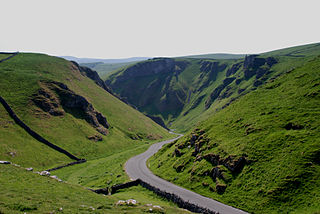
Winnats Pass is a hill pass and limestone gorge in the Peak District of Derbyshire, England. The name is a corruption of 'wind gates' due to the swirling winds through the pass. It lies west of the village of Castleton, in the National Trust's High Peak Estate and the High Peak borough of Derbyshire. The road winds through a cleft, surrounded by high limestone ridges. At the foot of the pass is the entrance to Speedwell Cavern, a karst cave accessed through a flooded lead mine, and which is a popular tourist attraction.

The A6187 is a secondary route in the Peak District, Derbyshire and South Yorkshire, England. It starts in Castleton, runs in an easterly direction past Fox House Inn where it joins the A625 road. It is 13.6 miles long.

The A624 road is a main road in the English county of Derbyshire. It connects Glossop to Chapel-en-le-Frith passing through Chunal, Hayfield, and New Smithy.
The Sheffield to Hathersage turnpike was an early road through the English Peak District, which was improved by a turnpike trust in the 18th century. The road may have originated as a Roman road.

Long Causeway or Long Causey was a medieval packhorse route in England, which ran between Sheffield in South Yorkshire and Hathersage in Derbyshire. In the past the route has been marked on maps as a Roman Road as it was believed it followed part of the route of Batham Gate between Templeborough and Buxton, although in recent years some scholars have cast doubt on this.


