
The Peak District is an upland area in central-northern England, at the southern end of the Pennines. Mostly in Derbyshire, it extends into Cheshire, Greater Manchester, Staffordshire, West Yorkshire and South Yorkshire. It is subdivided into the Dark Peak, moorland dominated by gritstone, and the White Peak, a limestone area with valleys and gorges. The Dark Peak forms an arc on the north, east and west of the district, and the White Peak covers central and southern areas. The highest point is Kinder Scout. Most of the area is within the Peak District National Park, a protected landscape designated in 1951.

Mam Tor is a 517 m (1,696 ft) hill near Castleton in the High Peak of Derbyshire, England. Its name means "mother hill", so called because frequent landslips on its eastern face have resulted in a multitude of "mini-hills" beneath it. These landslips, which are caused by unstable lower layers of shale, also give the hill its alternative name of Shivering Mountain.

Castleton is a village and civil parish in the High Peak district of Derbyshire, England, at the western end of the Hope Valley on the Peakshole Water, a tributary of the River Noe, between the Dark Peak to the north and the White Peak to the south. The population was 642 at the 2011 Census.

Hope is a village and civil parish in the Derbyshire Peak District, in England. The population at the 2011 Census was 864. It lies in the Hope Valley, at the point where Peakshole Water flows into the River Noe. To the north, Win Hill and Lose Hill stand either side of the Noe.

The Hope Valley is a rural area centred on the village of Hope, Derbyshire, in the Peak District in the northern Midlands of England.

This article details some of the history of lead mining in Derbyshire, England.

Speedwell Cavern is one of the four show caves in Castleton, Derbyshire, England.

Treak Cliff Cavern is a show cave near Castleton in Derbyshire, England. It is part of the Castleton Site of Special Scientific Interest and one of only two sites where the ornamental mineral Blue John is still excavated. As part of an agreement with English Nature, the Blue John that can be seen in the show cave is not mined but it is extracted in small quantities from other areas of the cave and made into saleable items like bowls, jewellery, and ornaments.
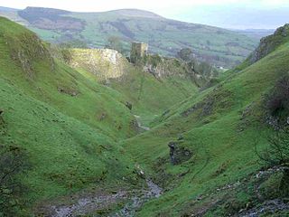
Cave Dale is a dry limestone valley in the Derbyshire Peak District, England. It is located at grid reference SK149824. The northern end of the dale starts at the village of Castleton where the valley sides are almost perpendicular and over 50 metres (160 ft) in height. The dale rises gently after leaving Castleton for approximately 200 metres (220 yd) before becoming steeper culminating in a fine viewpoint down the dale taking in Peveril Castle with Lose Hill behind. After the viewpoint the dale swings west and levels out with gentle gradients, becoming just a shallow depression as it peters out onto the open pastureland between Castleton and Chapel-en-le-Frith.

Trevor David Ford was an English geologist and author, best known for publishing the first report on the Precambrian fossil Charnia masoni in 1958. In addition to paleontology, his wide-ranging research encompassed geomorphology, speleology, studies of minerals and mineralisation, and mining history, and mainly focused on the Peak District. His academic career was at the Department of Geology of the University of Leicester, where he rose to be a senior lecturer (1980–87) and associate dean for combined studies in science. He was the founding editor of the journal now entitled Cave and Karst Science (1973–93), and published many books, both academic texts and books aimed at a broader audience, including cave guides, and guides to geology and minerals.
Oxlow Cavern is a part-natural and part-mined cavern near Castleton in Derbyshire, England. It is situated on the south side of the road running from the A623 at Sparrowpit to the Winnats Pass, west of Castleton, and is almost opposite Giant's Hole on the other side of the road. A few yards from Oxlow Cavern is the connecting Maskill Mine.

Eldon Hill is a hill in the Peak District National Park in the county of Derbyshire, England, 4 kilometres (2.5 mi) southwest of the village of Castleton. It is a 470-metre (1,540 ft) limestone hill whose pastureland is used for rough grazing, although a large proportion has been lost to limestone quarrying. It lies within the Castleton Site of Special Scientific Interest. Eldon Hill was formed when a bed of pure limestone was squeezed and upfolded by geological forces to form a dome; it is the highest limestone hill north of the River Wye.
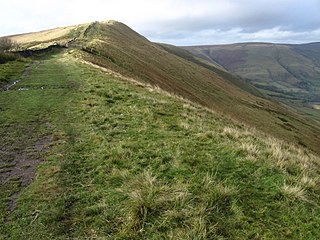
Rushup Edge is a ridge in the Derbyshire Peak District of England. The ridge's highest point is Lord's Seat at 550 m (1,804 ft), while Mam Tor lies beyond its eastern end, at the western end of the Great Ridge.

Blue John is a semi-precious mineral, a rare form of fluorite with bands of a purple-blue or yellowish colour. In the United Kingdom it is found only at Blue John Cavern and Treak Cliff Cavern at Castleton in Derbyshire. During the 19th century, it was mined for its ornamental value, and mining continues on a small scale.

Magpie Mine is a well-preserved disused lead mine near the village of Sheldon in Derbyshire, England, in the parish of Ashford in the Water. The walled enclosure of five lead mines is a protected Scheduled Monument.

Coombs Dale is a steep-sided, dry carboniferous limestone valley in the Derbyshire Peak District of England. The village of Calver lies about 1 km to the east and the village of Stoney Middleton lies less than 1 km to the north. The dale is cut into the hills on the east side of Longstone Moor. The upper end of the dale is known as Rough Side. Several springs flow down the dale during winter and after heavy rains.

The Derbyshire Dome is a geological formation across mid-Derbyshire in England.

Bradwell Moor is a moorland hill above the village of Bradwell, Derbyshire in the Peak District. The summit is 471 metres (1,545 ft) above sea level.
The geology of the Peak District National Park in England is dominated by a thick succession of faulted and folded sedimentary rocks of Carboniferous age. The Peak District is often divided into a southerly White Peak where Carboniferous Limestone outcrops and a northerly Dark Peak where the overlying succession of sandstones and mudstones dominate the landscape. The scarp and dip slope landscape which characterises the Dark Peak also extends along the eastern and western margins of the park. Although older rocks are present at depth, the oldest rocks which are to be found at the surface in the national park are dolomitic limestones of the Woo Dale Limestone Formation seen where Woo Dale enters Wye Dale east of Buxton.
Castleton is a Site of Special Scientific Interest (SSSI) in Derbyshire, England within Peak District National Park. It is located between Castleton and Sparrowpit, close to Edale and borders Mam Tor hill. This protected area includes Winnats Pass.


