
The River Wye is a limestone river in the Peak District of Derbyshire, England. It is 22 miles long, and is one of the major tributaries of the River Derwent, which flows into the River Trent, and ultimately into the Humber and the North Sea.

Bakewell is a market town and civil parish in the Derbyshire Dales district of Derbyshire, England, known for Bakewell pudding. It lies on the River Wye, 15 miles (23 km) south-west of Sheffield. It is the largest settlement and only town within the boundaries of the Peak District National Park. At the 2011 census, the population of the civil parish was 3,949. It was estimated at 3,695 in 2019. The town is close to the tourist attractions of Chatsworth House and Haddon Hall.
Peak Rail is a preserved railway in Derbyshire, England, which operates a steam and heritage diesel service for tourists and visitors to both the Peak District and the Derbyshire Dales.
The Manchester, Buxton, Matlock and Midland Junction Railway ran from a junction with the Midland Railway at Ambergate to Rowsley north of Matlock and thence to Buxton.

Rowsley is a village on the A6 road in the English county of Derbyshire. The population as at the 2011 census was 507.

Haddon Tunnel was built by the Midland Railway in 1863 when extending the Manchester, Buxton, Matlock and Midlands Junction Railway from Rowsley to Buxton in Derbyshire, England.

Blackwell Mill is a location in Derbyshire, England; it lies near to, but not part of, the village of Blackwell near Buxton. It stands at the meeting point of several valleys: Great Rocks Dale, Chee Dale and Ashford Dale. A railway station was sited here by the Midland Railway; it operated for 92 years.

Millers Dale is a valley on the River Wye in Derbyshire, England, where there is also a hamlet of the same name.

Millers Dale railway station was in Millers Dale, near Tideswell, in Derbyshire, England. It was opened in 1863 by the Midland Railway on its line from Rowsley, extending the Manchester, Buxton, Matlock and Midlands Junction Railway. It closed in 1967 and the site is now used as a car park for the Monsal Trail, which follows the trackbed.

Cressbrook is a village in the Peak District National Park in Derbyshire. It lies in Water-cum-Jolly Dale at the foot of Cressbrook Dale. Population details at the 2011 Census are included in the civil parish of Litton. Before its Enclosure Act of 1762 Cressbrook did not exist. It later grew up around a textile mill complex built alongside the River Wye, first by Richard Arkwright and then later by his son Richard, JL Philips and Brother Cotton Spinners and McConnel and Company.
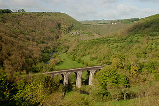
The Monsal Trail is a cycling, horse riding and walking trail in the Derbyshire Peak District. It was constructed from a section of the former Manchester, Buxton, Matlock and Midland Junction Railway, which was built by the Midland Railway in 1863 to link Manchester with London and closed in 1968. The Monsal Trail is about 8.5 miles (13.7 km) long and opened in 1981. It starts at the Topley Pike junction in Wye Dale, 3 miles (4.8 km) east of Buxton, and runs to Coombs Viaduct, 1 mile (1.6 km) south-east of Bakewell. It follows the valley of the River Wye. The trail passes through Blackwell Mill, Chee Dale, Millers Dale, Cressbrook, Monsal Dale, Great Longstone, Hassop and Bakewell. The trail has numerous landmarks including Headstone Viaduct, Cressbrook Mill, Litton Mill and Hassop railway station, and passes through six tunnels.
Wormhill is a village and civil parish in the High Peak district of Derbyshire, England, situated east by north of Buxton. The population of the civil parish including Peak Dale was 1,020 at the 2011 Census.

Monsal Dale railway station served the villages of Upperdale and Cressbrook in Derbyshire, England. It was opened in 1866 by the Midland Railway on its line from Rowsley, extending the Manchester, Buxton, Matlock and Midlands Junction Railway.

Bakewell railway station served the town of Bakewell in Derbyshire, England. It was built by the Midland Railway on its extension of the Manchester, Buxton, Matlock and Midland Junction Railway line from Rowsley to Buxton. The station was closed in 1967. Peak Rail Heritage Railway intends to reopen the station to trains by extending its existing Matlock to Rowsley South line 4 miles through Rowsley to Bakewell.
The White Peak Loop is a 60-mile (97 km) route for walking, cycling and horse riding in the Peak District of England. The trail combines sections of the High Peak Trail and the Monsal Trail with linking sections through the towns of Buxton, Bakewell and Matlock. The White Peak Loop is being developed by Derbyshire County Council and as of 2022 some sections are not yet complete.

Chee Dale is a steep-sided gorge on the River Wye near Buxton, Derbyshire, in the Peak District of England.
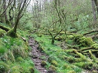
Monk's Dale is a short steep-sided dry gorge near Buxton, Derbyshire, in the Peak District of England. The dale is cut into a plateau of farmland and lies to the east of the village of Wormhill. The head of the valley leads into Peter Dale to the north. Miller's Dale is at the foot of the valley to the south.

Cressbrook Dale is a dry carboniferous limestone gorge near Bakewell, Derbyshire, in the Peak District of England. The dale is cut into a plateau of farmland and lies to the south east of the village of Litton. Cressbrook village is at the foot of the valley to the south.

Tideswell Dale is a short dry limestone valley near Tideswell village, Derbyshire, in the Peak District of England. There is a farmland plateau on either side. The foot of the valley leads into Miller's Dale on the River Wye, which the valley's Brook Head stream runs into.

The Wye Valley is the limestone valley of the River Wye in the White Peak of Derbyshire, England. The source of the River Wye is west of Buxton on Axe Edge Moor. One main channel runs underground through Poole's Cavern. The river flows though Buxton Pavilion Gardens and then along a culvert under the town centre. After leaving the flat area of central Buxton, the Wye Valley becomes distinct as a gorge running east for 10 miles (16 km) before the valley broadens at Ashford-in-the Water.


