
The Peak District is an upland area in central-northern England, at the southern end of the Pennines. Mostly in Derbyshire, it extends into Cheshire, Greater Manchester, Staffordshire, West Yorkshire and South Yorkshire. It is subdivided into the Dark Peak, moorland dominated by gritstone, and the White Peak, a limestone area with valleys and gorges. The Dark Peak forms an arc on the north, east and west of the district, and the White Peak covers central and southern areas. The highest point is Kinder Scout. Most of the area is within the Peak District National Park, a protected landscape designated in 1951.

Mam Tor is a 517 m (1,696 ft) hill near Castleton in the High Peak of Derbyshire, England. Its name means "mother hill", so called because frequent landslips on its eastern face have resulted in a multitude of "mini-hills" beneath it. These landslips, which are caused by unstable lower layers of shale, also give the hill its alternative name of Shivering Mountain.

Castleton is a village and civil parish in the High Peak district of Derbyshire, England, at the western end of the Hope Valley on the Peakshole Water, a tributary of the River Noe, between the Dark Peak to the north and the White Peak to the south. The population was 642 at the 2011 Census.

The Peak Cavern, also known as the Devil's Arse, is one of the four show caves in Castleton, Derbyshire, England. Peakshole Water flows through and out of the cave, which has the largest cave entrance in Britain.

Speedwell Cavern is one of the four show caves in Castleton, Derbyshire, England.

Treak Cliff Cavern is a show cave near Castleton in Derbyshire, England. It is part of the Castleton Site of Special Scientific Interest and one of only two sites where the ornamental mineral Blue John is still excavated. As part of an agreement with English Nature, the Blue John that can be seen in the show cave is not mined but it is extracted in small quantities from other areas of the cave and made into saleable items like bowls, jewellery, and ornaments.
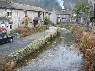
Peakshole Water is a stream in the Derbyshire Peak District named after its source, Peak Cavern. It flows through the village of Castleton to join the River Noe in nearby Hope. Despite its name, much of its flow actually emerges from the Russet Well, a resurgence in a garden on the east side of the gorge below the main Peak Cavern entrance, described as the "main resurgence of the Castleton area", which drains a series of swallets on the other side of the Pennine watershed below Rushup Edge. The resurgence has been explored by cave divers to a depth of 82 feet (25 m) but further exploration was halted by a constriction.
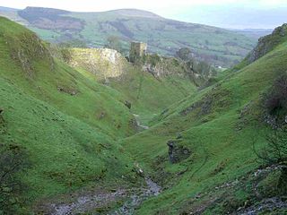
Cave Dale is a dry limestone valley in the Derbyshire Peak District, England. It is located at grid reference SK149824. The northern end of the dale starts at the village of Castleton where the valley sides are almost perpendicular and over 50 metres (160 ft) in height. The dale rises gently after leaving Castleton for approximately 200 metres (220 yd) before becoming steeper culminating in a fine viewpoint down the dale taking in Peveril Castle with Lose Hill behind. After the viewpoint the dale swings west and levels out with gentle gradients, becoming just a shallow depression as it peters out onto the open pastureland between Castleton and Chapel-en-le-Frith.
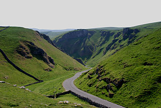
Winnats Pass is a hill pass and limestone gorge in the Peak District of Derbyshire, England. The name is a corruption of 'wind gates' due to the swirling winds through the pass. It lies west of the village of Castleton, in the National Trust's High Peak Estate and the High Peak borough of Derbyshire. The road winds through a cleft, surrounded by high limestone ridges. At the foot of the pass is the entrance to Speedwell Cavern, a karst cave accessed through a flooded lead mine, and which is a popular tourist attraction.
Titan is a natural cavern near Castleton in the Derbyshire Peak District, and is the deepest shaft of any known cave in Britain, at 141.5 metres (464 ft). The existence of Titan was revealed in November 2006, following its discovery on 1 January 1999 after cavers discovered connections from the James Hall Over Engine Mine to both Speedwell Cavern and Peak Cavern. Previously, the deepest known underground shaft in Britain had been Gaping Gill on the slopes of Ingleborough in the Yorkshire Dales.
Oxlow Cavern is a part-natural and part-mined cavern near Castleton in Derbyshire, England. It is situated on the south side of the road running from the A623 at Sparrowpit to the Winnats Pass, west of Castleton, and is almost opposite Giant's Hole on the other side of the road. A few yards from Oxlow Cavern is the connecting Maskill Mine.

Bradwell is a village and civil parish in the Derbyshire Peak District of England. The population of the civil parish taken at the 2011 Census was 1,416. It lies south of the main body of the Hope Valley but is usually included among its settlements.

Odin Mine is a disused lead mine in the Peak District National Park, situated at grid reference SK133835. It lies on a site of 25 hectares near the village of Castleton, England. It is the oldest documented mine in Derbyshire and is thought to be one of the oldest lead mines in England. The mine is a Scheduled Ancient Monument and has biological and geological significance within the Castleton Site of Special Scientific Interest.

Giant's Hole is a well-known cave near Castleton in Derbyshire, consisting mostly of large passages. It is a stream-way cave, and part of the Karst topography of the area.

Little Hucklow is a village and civil parish in Derbyshire. Whilst it is a separate civil parish in the Derbyshire Dales District, the Parish Council is joint with Great Hucklow, and Grindlow. The parish consists of the village of Little Hucklow and the hamlets of Coplow Dale and Windmill.

Blue John is a semi-precious mineral, a rare form of fluorite with bands of a purple-blue or yellowish colour. In the United Kingdom it is found only at Blue John Cavern and Treak Cliff Cavern at Castleton in Derbyshire. During the 19th century, it was mined for its ornamental value, and mining continues on a small scale.

The Derbyshire Dome is a geological formation across mid-Derbyshire in England.
Castleton is a Site of Special Scientific Interest (SSSI) in Derbyshire, England within Peak District National Park. It is located between Castleton and Sparrowpit, close to Edale and borders Mam Tor hill. This protected area includes Winnats Pass.


