
The River Etherow in northern England is a tributary of the River Goyt. Although now passing through South Yorkshire, Derbyshire and Greater Manchester, it historically formed the ancient county boundary between Cheshire and Derbyshire. The upper valley is known as Longdendale. The river has a watershed of approximately 30 square miles (78 km2), and the area an annual rainfall of 52.5 inches (1,330 mm).

The Ashover Light Railway was a 1 ft 11+1⁄2 in narrow gauge railway in Derbyshire, England that connected Clay Cross and Ashover. It was built by the Clay Cross Company to transport minerals such as limestone, fluorite, barytes and gritstone to its works at Clay Cross and for transport around the country by the LMS.

Stanwell is a village in the Spelthorne district, in Surrey, England. It is 16 miles (26 km) west of central London. A small corner of its land is used as industrial land for nearby Heathrow Airport. The rest of the village is made up of residential and recreational land. Historically part of the county of Middlesex, it has, like the rest of Spelthorne, been in Surrey since 1965. The village is to the south of the cargo-handling area of Heathrow Airport and to the east of the Staines Reservoirs. Stanwell is the northernmost settlement in Surrey, bordering Berkshire and Greater London.
The River Amber is a left bank tributary of the River Derwent in Derbyshire, England. It gives its name to the local government district and borough of Amber Valley.

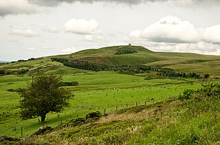
Ashover is a village and civil parish in the English county of Derbyshire. It is in the North East Derbyshire district of the county. The population of the civil parish taken at the 2011 Census was 1,905, increasing to 1,959 for the 2021 census. It sits in a valley, not far from the town of Matlock and the Peak District national park.

Anglezarke is a sparsely populated civil parish in the Borough of Chorley in Lancashire, England. It is an agricultural area used for sheep farming and is also the site of reservoirs that were built to supply water to Liverpool. The area has a large expanse of moorland with many public footpaths and bridleways. The area is popular with walkers and tourists; it lies in the West Pennine Moors in Lancashire, sandwiched between the moors of Withnell and Rivington, and is close to the towns of Chorley, Horwich and Darwen. At the 2001 census it had a population of 23, but at the 2011 census the population was included within Heapey civil parish. The area was subjected to depopulation after the reservoirs were built.

Greenfield is a small village about 2 km (1.2 mi) from the town of Flitwick in Bedfordshire, England. It lies across Flitwick Moor from the larger settlement of Flitwick and is on the opposite side of the River Flit. It forms part of the parish of Flitton and Greenfield.
Rivington is a village and civil parish of the Borough of Chorley, Lancashire, England, occupying 2,538 acres. It is about 6 miles (9.7 km) southeast of Chorley and about 8+1⁄2 miles (13.7 km) northwest of Bolton. Rivington is a rural area consisting primarily of agricultural grazing land, moorland, with hill summits including Rivington Pike and Winter Hill within the West Pennine Moors. The area has a thriving tourist industry centred around reservoirs created to serve Liverpool in the Victorian era and Lever Park created as a public park by William Lever at the turn of the 20th century, with two converted barns, a replica of Liverpool Castle and open countryside. Rivington and Blackrod High School is located here. Rivington and its village had a population of 109 at the 2011 Census.

The Ashokan Reservoir is a reservoir in Ulster County, New York. It is at the eastern end of the Catskill Park, and is one of several in the region created to provide the City of New York with water. It is the city's deepest reservoir at 190 feet (58 m) near the dam at the former site of Bishop Falls.

Haslingden Grane is the glaciated upper portion of the valley of the River Ogden, which lies west of Haslingden and is in the north east section of the West Pennine Moors. To the north is Oswaldtwistle Moor, and to the south Musbury Heights. It was once the home of Grane village, and is easily accessible via the B6232/A6077 Grane Road which links to the M65 motorway and the A56. Grane valley is dominated by its three reservoirs, Holden Wood, Calf Hey and Ogden.
Woolley Moor is a small village in the North East Derbyshire district of Derbyshire, England. Its amenities include a school, a church and a public house called the White Horse. Almost all of the villagers work outside the village although there are two family run dairy farms creating employment for a handful of people.

Stretton is a small village and civil parish in Derbyshire, England. The population of the civil parish as at the 2011 Census was 525. It is near the towns of Clay Cross and 3.5 miles (5.6 km) from Alfreton on the A61. The nearest waterways are the River Amber and Smithy Brook. Since 1964, Stretton has been beside Ogston Reservoir which still has the remains of a pub and a light railway within its depths.

Kirkmichael is a village located in Strathardle, Perth and Kinross, Scotland. It is 13 miles north-northwest of Blairgowrie and 12 miles east-northeast of Pitlochry on the A924 Bridge of Cally to Pitlochry road, and is linked to the A93 Perth to Aberdeen road by the B950. The village is centred around Kirkmichael Bridge over the River Ardle.

Moor Row is a village in Cumbria, North West England. It is in Egremont civil parish and lies on a minor road off the A595, south-east of Whitehaven. In 2018 it had an estimated population of 759.

The River Dove is a river that extends through the Low Valley in Barnsley, England. It flows from Worsbrough Reservoir to its confluence with the River Dearne.
The National Camps Corporation was a British government-funded non-profit organisation established under the Camps Act 1939. The role of the corporation was to construct and administer camps in the countryside that could be used for educational experiences.
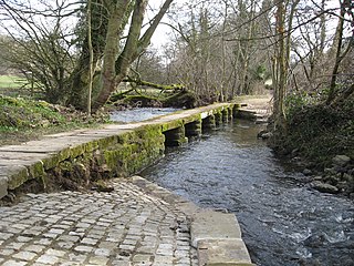
Woolley railway station was a small station on the Ashover Light Railway and it served the small village of Woolley Moor in North East Derbyshire, England. The station had a wooden shelter and a telephone box. As well as a platelayers hut. It was located just north of Ogston Reservoir, passenger traffic was initially good. After closure in 1950, the site was demolished and nothing remains of the station but the trackbed is visible although the section to Stretton has been submerged.

Brampton is a civil parish in North East Derbyshire, England, with a population of 1,201 in 2011. Lying 130 miles (210 km) north west of London, 20 miles (32 km) north of Derby, and 2 miles (3.2 km) west of the market town of Chesterfield, Brampton encompasses part of the Peak District national park to the west, and shares a border with the Borough of Chesterfield, Barlow, Baslow and Bubnell, Beeley, and Holymoorside and Walton. The parish contains a number of settlements including the village it was named after, but does not include the nearby built-up suburb of Brampton which is now within the Chesterfield unparished area.

Holymoorside and Walton is a civil parish within the North East Derbyshire district, which is in the county of Derbyshire, England. Named for its main settlements, with a mix of a number of villages and hamlets amongst a large rural area, it had a population of 2,138 residents in 2021. The parish is 130 miles (210 km) north west of London, 20 miles (32 km) north of the county city of Derby, and 2 miles (3.2 km) south west of the nearest market town of Chesterfield. It is adjacent with the Peak District national park to the west, and shares a border with the district of Chesterfield, along with the parishes of Ashover, Beeley, Brampton as well as Wingerworth. The parish paradoxically does not include the majority of the nearby built-up suburb of Walton, Chesterfield which is now within an adjacent unparished area of the borough.


