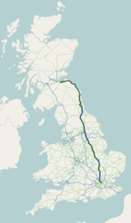
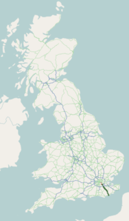
The A1 is the longest numbered road in the UK, at 410 miles (660 km). It connects London, the capital of England, with Edinburgh, the capital of Scotland. It passes through or near North London, Hatfield, Welwyn Garden City, Stevenage, Baldock, Letchworth Garden City, Biggleswade, St Neots, Huntingdon, Peterborough, Stamford, Grantham, Newark-on-Trent, Retford, Doncaster, York, Pontefract, Wetherby, Ripon, Darlington, Durham, Sunderland, Gateshead, Newcastle upon Tyne, Morpeth, Alnwick and Berwick-upon-Tweed.
For other roads with the same name see List of A21 roads.

The A19 is a major road in England running approximately parallel to and east of the A1 road. Although the two roads meet at the northern end of the A19, the two roads originally met at the southern end of the A19 in Doncaster, but the old route of the A1 was changed to the A638. From Sunderland northwards, the route was formerly the A108. In the past the route was known as the East of Snaith-York-Thirsk-Stockton-on-Tees-Sunderland Trunk Road. Most traffic joins the A19, heading for Teesside, from the A168 at Dishforth Interchange.

The A28 is a trunk road in the counties of Kent and East Sussex in south east England, connecting Margate, Canterbury, Ashford and Hastings.

Houghton-le-Spring is a town in the City of Sunderland, Tyne and Wear, North East England which has its recorded origins in Norman times. Historically in County Durham, it is now administered as part of the Tyne and Wear county. It is situated almost equidistant between the cathedral city of Durham 7 miles southwest and Sunderland about 7 mi (11 km) northeast. The town of Seaham and the North Sea lie about 5 mi (8 km) directly east. The villages and towns of Newbottle, Fencehouses and Hetton-le-Hole lie nearby. It has a population of 36,746.

Newbottle is a village in North East England, lying between Durham and Sunderland, one and a half miles north of Houghton-le-Spring. The village occupies an elevated position and is accessed from three sides up a steep bank.

The village of Penshaw, formerly known as Painshaw or Pensher, is an area of the metropolitan district of the City of Sunderland, in Tyne and Wear, England. Historically, Penshaw was located in County Durham.

The A64 is a major road in North and West Yorkshire, England, which links Leeds, York and Scarborough. The A64 starts as the A64(M) ring road motorway in Leeds, then towards York it becomes a high-quality dual carriageway until it is east of York, where it becomes a single carriageway for most of its route to Scarborough.

The A689 is a road in northern England that runs east from the A595, 3.1 miles (5.0 km) to the west of Carlisle in Cumbria, to Hartlepool in County Durham.
Barnes is an inner suburb in the southwest of Sunderland in northeast England, situated about a mile from the city centre. The area is split into Barnes, which lies towards the east, and High Barnes, which lies around Barnes Park and the Bede Sixth Form Centre of City of Sunderland College. Barnes is bounded by Chester Road to the north, Durham Road on the south, Springwell Road to the west and the city centre to the east. However, these boundaries are not officially set; views vary as to where the area begins and ends. The population of this ward taken at the 2011 Census was 10,987.

The A54 road is a road in England linking Chester in Cheshire with Buxton in Derbyshire. Its route through both urban and steep rural areas presents a challenge to Cheshire County Council in maintaining the safety of the road. Many years ago it was the main East-West Route in Cheshire The importance of the A54 through Middlewich and Winsford was decreased in the 1970s/1980s with the building of the M56 and dualling of the A556 at Northwich. The Section through Winsford carries approximately 30,000 vehicles per day.
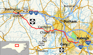
North Carolina Highway 54 (NC 54) is a 55.0-mile-long (88.5 km) primary state highway in the U.S. state of North Carolina. The highway serves the Research Triangle area, between Burlington and Raleigh, connecting the cities and towns of Chapel Hill, Durham, Morrisville and Cary. The highway also links the campuses of University of North Carolina at Chapel Hill and North Carolina State University.
East Rainton is a village found in the outskirts of Durham, in the City of Sunderland, Tyne and Wear, in the north east of England. It is situated alongside the A690 road between Sunderland and Durham, near Houghton-le-Spring.
The A688 is a road in County Durham in North East England.

The A1231 road connects Sunderland and Washington in Tyne and Wear, North East England. It is the main road connecting these towns and is one of the main roads giving access to Sunderland city centre. The total length of the road is approximately 9 miles (14 km).

The A1018 is a road in North East England. It runs between South Shields, at the mouth of the River Tyne, and the A19 near Seaham, County Durham. Most of the route it follows is the old alignment of the A19, before it by-passed Sunderland to meet the Tyne Tunnel.

Fence Houses, or Fencehouses, is a small village within the parish of Houghton-le-Spring, on the edge of the City of Sunderland, England for the South with the North under the control of Durham County Council as part of County Durham.

The A631 is a road running from Sheffield, South Yorkshire to Louth, Lincolnshire in England. It passes through the counties of South Yorkshire, Nottinghamshire and Lincolnshire. The road has many towns on its route including Rotherham, Maltby, Gainsborough and Market Rasen. It is mostly single road throughout its length but has some stretches of dual carriageway as well. The road is approximately 65 miles (105 km) long.
Holmesglen Highway is a major inner urban highway in southeastern Melbourne, Australia. On weekdays, it is heavily trafficked as it runs through many major suburbs along its route, traversing Melbourne's inner eastern and south-eastern suburbs. This includes suburbs Chadstone, Oakleigh, and Cheltenham. The Chadstone Shopping Centre can be accessed directly from Warrigal Road at its eastern entrance. It carries Metropolitan Route Number 15 for its entire length, and formerly contained Route Number 14 between Kingston Road and South Road before that route was diverted onto the South Road-Kingston Road section of the new Dingley Bypass that opened in 2016.