
Glossop is a market town in the borough of High Peak, in the county of Derbyshire, England. It is located 15 miles (24 km) east of Manchester, 24 miles (39 km) north-west of Sheffield and 32 miles (51 km) north of the county town, Matlock. Glossop lies near Derbyshire's borders with Cheshire, Greater Manchester, South Yorkshire and West Yorkshire. It is between 150 and 300 metres above sea level and is bounded by the Peak District National Park to the south, east and north. In 2021 it had a population of 33,340.

Castleton is a village in the High Peak district of Derbyshire, England, at the western end of the Hope Valley on the Peakshole Water, a tributary of the River Noe, between the Dark Peak to the north and the White Peak to the south. The population was 642 at the 2011 Census.

The M67 is a 5-mile (8.0 km) urban motorway in Greater Manchester, England, which heads east from the M60 motorway passing through Denton and Hyde before ending near Mottram. The road was originally conceived as the first section of a trans-Pennine motorway between Manchester and Sheffield that would connect the A57(M) motorway with the M1 motorway; however, the motorway became the only part to be built.

The A6 is one of the main north–south roads in England. It runs from Luton in Bedfordshire to Carlisle in Cumbria, although it formerly started at a junction with the A1 at Barnet. It is the fourth longest numbered road in Britain; only the A1, A38 and A30 are longer.

The A57 is a major road in England. It runs east from Liverpool to Lincoln via Warrington, Salford and Manchester, and then through the Pennines over the Snake Pass (between the high moorlands of Bleaklow and Kinder Scout), around the Ladybower Reservoir, through Sheffield and past Worksop. Between Liverpool and Glossop, the road has largely been superseded by the M62, M602 and M67 motorways. Within Manchester a short stretch becomes the Mancunian Way, designated A57(M).

High Peak is a local government district with borough status in Derbyshire, England, covering a high moorland plateau in the Dark Peak area of the Peak District National Park. The district stretches from Holme Moss in the north to Sterndale Moor in the south, and from Hague Bar in the west to Bamford in the east. The population of the borough taken at the 2011 Census was 90,892. The borough is unusual in having two administrative centres for its council, High Peak Borough Council; the offices are in Buxton and Glossop. Other towns include Chapel-en-le-Frith, Hadfield, New Mills and Whaley Bridge.
New Mills is a town in the Borough of High Peak, Derbyshire, England, 8 miles (13 km) south-east of Stockport and 13 miles (21 km) from Manchester at the confluence of the River Goyt and Sett. It is close to the border with Cheshire and above the Torrs, a 70 feet (21 m) deep gorge cut through carboniferous sandstone, on the north-western edge of the Peak District national park.

Chinley is a rural village in the High Peak Borough of Derbyshire, England, with a population of 2,796 at the 2011 Census. Most of the civil parish is within the Peak District National Park. Historically, before the coming of the railway, the area was economically dominated by agriculture. Nowadays most inhabitants commute out of the village to work; accessible centres of work include Stockport, Sheffield and Manchester.

Hayfield is a village and civil parish in High Peak, Derbyshire, England, with a population of around 2,700. The village is 3 miles (4.8 km) east of New Mills, 4.5 miles (7.2 km) south of Glossop and 10 miles (16 km) north of Buxton, in the basin of the River Sett.

High Peak is a parliamentary constituency represented in the House of Commons of the UK Parliament since 2019 by Robert Largan, a Conservative.
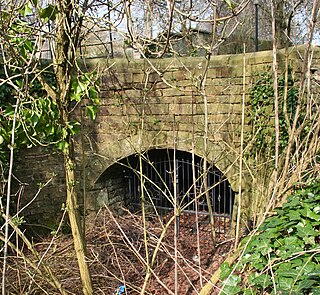
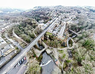
Stodhart Tunnel is a 100-yard (91 m) tunnel on the Peak Forest Tramway at Chapel Milton, Derbyshire. The tunnel stretches under the Chapel-en-le-Firth to Glossop Road. Although one side has been blocked up, it remains one of the oldest rail-related tunnels in the world and was also the site of one of the earliest rail-related accidents, when a laden carriage rolled into two horses, killing them.

The Buxton line is a railway line in Northern England, connecting Manchester with Buxton in Derbyshire. Passenger services on the line are currently operated by Northern Trains.

The A54 road is a road in England linking Chester in Cheshire with Buxton in Derbyshire. Its route through both urban and steep rural areas presents a challenge to Cheshire County Council in maintaining the safety of the road. Many years ago it was the main east–west route in Cheshire. The importance of the A54 through Middlewich and Winsford decreased in the 1970s and 1980s with the building of the M56 motorway and dualling of the A556 at Northwich. The section through Winsford carries approximately 30,000 vehicles per day.
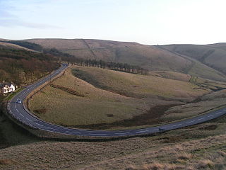
The A5004 is an A road in Derbyshire, England running north from Buxton to Whaley Bridge. A large section of the road is called Long Hill. It was formerly part of the A6. It runs through a scenic area of the Peak District National Park. In 2010 it was named as the seventh most dangerous road in Britain.

The A625 is a rural road which runs through north Derbyshire and the Peak District in England.

Bowers Coaches was a bus company based in Chapel-en-le-Frith, Derbyshire, England. The company operated bus and coach services in Cheshire East, Derbyshire and Greater Manchester from 1952 until 2012. In its later years, it was a subsidiary of Centrebus and in 2012 it was merged with the Dove Holes depot of Trent Barton to form High Peak Buses.

Chapel-en-le-Frith is a town and civil parish in the Borough of High Peak in Derbyshire, England.

The Street is the medieval name of the Roman road that ran across the high limestone plateau of central Derbyshire from the spa town of Buxton southeast towards modern Derby. The line of the road can be traced from surviving features, confirmed by archaeology, from Buxton as far as Longcliffe just north of Brassington. It is believed that from Brassington the road ran eastwards to Wirksworth and there joined another road which crossed the Derwent at Milford and ran on the east bank of the Derwent and can be traced to the northern suburbs of Derby to Little Chester, the site of the Roman settlement of Derventio. The 1723 map of Brassington Moor shows The Street road from Buxton through Pikehall up to the Upper Harborough Field Gate, leading onto Manystones Lane & Brassington Lane towards Wirksworth. In records from 1613 the road from Brassington to Wirksworth is called 'Highe Streete'.

New Smithy is a hamlet in the civil parish of Chinley, Buxworth and Brownside, Derbyshire, England, near the village of Chinley. It sits on the A624 trunk road from Glossop to Chapel-en-le-Frith featuring a TOTSO where left carries one down to Chapel and right heads to Chinley. There is a railway bridge over the turning, used for both freight and passengers, on the Hope Valley Line to Sheffield and Manchester; very close down the line is Chinley railway station. Next to this the Crown & Mitre pub, now converted into residential flats, is the main landmark and there are a couple of residential housing streets and terraces, and one or two businesses.

Chinley, Buxworth and Brownside is a civil parish within the High Peak district, which is in the county of Derbyshire, England. Partially rural with several villages contained within, its population was 2,794 residents in the 2021 census. The parish is 150 miles (240 km) north west of London, 35 miles (56 km) north west of the county city of Derby, and 1+1⁄3 miles (2.1 km) north of the nearest market town of Chapel-en-le-Frith. Being close to the edge of the county border, it shares a boundary with the parishes of Chapel-en-le-Frith, Edale, Hayfield, New Mills and Whaley Bridge. A substantial portion of the parish is within the Peak District national park.


