Derwent, Derbyshire

Last updated

Derwent
Derwent Village Uncovered - geograph.org.uk - 178743.jpg
Remains of the village exposed in 1995
Derbyshire UK location map.svg
Red pog.svg
Derwent
Location within Derbyshire
Population51 (2001)
District
Shire county
Region
Country England
Sovereign state United Kingdom
Post town HOPE VALLEY
Postcode district S33
Dialling code 01433
Police Derbyshire
Fire Derbyshire
Ambulance East Midlands
UK Parliament
List of places
UK
England
Derbyshire
53°23′N1°43′W / 53.38°N 1.72°W / 53.38; -1.72

Derwent was a village 'drowned' in 1944 when the Ladybower Reservoir in Derbyshire, England was created. The village of Ashopton, Derwent Woodlands church, and Derwent Hall were also 'drowned' in the construction of the reservoir.

Contents

Demolition

The church tower of Derwent slowly disappearing below the water as the reservoir was filled in 1946 Church tower at Ladybower Reservoir.png
The church tower of Derwent slowly disappearing below the water as the reservoir was filled in 1946

All buildings in the village had been demolished by autumn 1943, and the impounded waters of the reservoir began to rise by the end of 1944.

A 17th-century packhorse bridge in the village had a preservation order which prevented it from being demolished. In order to comply with this, the bridge was transported from the original location near Derwent Hall and reconstructed at the head of Howden Reservoir at Slippery Stones. It is now part of the footpaths and cycle tracks that run along the reservoirs. [1] [2] [3] The bridge is a scheduled monument, and it is one of the very few structures from Derwent village to have completely survived the reservoir's construction and still be visible. [4] [5]

The church held its last service on 17 March 1943. [6] The bell from the church may still be heard in Derbyshire, however, since it was re-hung in St Philip's Church in Chaddesden, built in 1955. The stained glass from the east window of the church, designed by Charles Eamer Kempe, was saved and installed into the east window of St Michael and All Angels' Church, Hathersage. Bodies from the graveyard at Derwent had been exhumed in 1940 and were reburied in the village of Bamford. [7] The church spire was left intact to form a memorial to Derwent. However, it was dynamited on 15 December 1947, on the rationale of safety concerns.

Remains

A packhorse bridge is one of the very few parts of Derwent that survived, having been moved to Slippery Stones. Slippery Stones Pack Horse Bridge - geograph.org.uk - 364629.jpg
A packhorse bridge is one of the very few parts of Derwent that survived, having been moved to Slippery Stones.

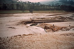
The site of the village has been revealed when the reservoir levels fell dramatically in 1976, 1989, 1995, [8] 2003, 2018 [9] and 2022. [10]

In 2018, the appearance of the village due to low water levels caused unprecedented crowds to visit the rarely visible site. On 3 November 2018, a man had to be rescued by a mountain rescue team after getting stuck in extremely thick mud around the ruins of the village. [11] On 17 November 2018 it was reported that the site had been vandalised by some of those visiting, with park rangers forced to stop visitors removing items from the site and with graffiti scrawled on some buildings. [12]

Although nearly the whole village was flooded, a few houses survive above the waterline. One source notes that five houses from the old village remain, as well as the village hall and several farms. [13] There remains a civil parish of Derwent. At the time of the 2001 UK census, it had a population of 51. At the 2011 Census, the population remained less than 100. Details were included in the civil parish of Aston, Derbyshire.

The most significant surviving reminder of Derwent Village is the village's packhorse bridge, painted in 1925 by the artist Stanley Royle. The bridge was transported and rebuilt at the head of Howden Reservoir at Slippery Stones where it now forms part of the paths and cycle tracks around the Derwent Valley reservoirs. [14] The Derwent Valley Museum, formerly [15] located on the Derwent Reservoir dam and run privately by the late Vic Hallam, told the history of the Derwent valley and of Derwent and Ashopton as well as the tale of RAF Squadron 617 ("The Dam Busters") and its training for Operation Chastise during the Second World War. [16]

There is no formal memorial to any of the villages. However, the site of the temporary village at Birchinlee, built to house the construction workers for the higher Derwent and Howden Reservoirs, is marked by a plaque. The only marker of the location of Derwent is the village's War Memorial, which stands above Ladybower Reservoir at a point to the west of the village. [17]

Notable residents

See also

Related Research Articles

The Upper Derwent Valley is an area of the Peak District National Park in England. It largely lies in Derbyshire, but its north eastern area lies in Sheffield, South Yorkshire. Its most significant features are the Derwent Dams, Ladybower, Derwent and Howden, which form Ladybower Reservoir, Derwent Reservoir and Howden Reservoir respectively.

<span class="mw-page-title-main">River Derwent, Derbyshire</span> River in Derbyshire, England

The Derwent is a river in Derbyshire, England. It is 50 miles (80 km) long and is a tributary of the River Trent, which it joins south of Derby. Throughout its course, the river mostly flows through the Peak District and its foothills.

<span class="mw-page-title-main">Birchinlee</span> Human settlement in England

Birchinlee is the site of "Tin Town", a village built by the Derwent Valley Water Board for the workers who constructed the Derwent and Howden Dams between 1902 and 1916. Most of the workers had previously been engaged in the construction, in Wales, of the Elan Valley Reservoirs where the accommodation was very basic. At Birchinlee, a "model village" was built; its infrastructure included hospitals, school, canteen (pub), post office, shops, recreation hall, public bath house, police station, railway station, rubbish dump with incinerator, and much else. One of the shops was a well-stocked store owned by the Gregory brothers from Tideswell. Accommodation consisted of workmen's huts, foremen's huts and married workmen's huts. The latter were decorated to a high standard, as photographs from the period confirm. The population rose to 900 people.

<span class="mw-page-title-main">Derwent Reservoir (Derbyshire)</span> Reservoir in Derbyshire, England

Derwent Reservoir is the middle of three reservoirs in the Upper Derwent Valley in the north of Derbyshire, England. It lies approximately 10 mi (16 km) from Glossop and 10 mi (16 km) from Sheffield. The River Derwent flows first through Howden Reservoir, then Derwent Reservoir and finally through Ladybower Reservoir. Between them they provide practically all of Derbyshire's water, as well as to a large part of South Yorkshire and as far afield as Nottingham and Leicester.

<span class="mw-page-title-main">Howden Reservoir</span> Reservoir in the Peak District, England

The Howden Reservoir is a Y-shaped reservoir, the uppermost of the three in the Upper Derwent Valley, England. The western half of the reservoir lies in Derbyshire and the eastern half is in Sheffield, South Yorkshire; the county border runs through the middle of the reservoir, following the original path of the River Derwent. The longest arm is around 1+14 mi (2.0 km) in length. The reservoir is bounded at the southern end by Howden Dam; below this, the Derwent flows immediately into Derwent Reservoir and subsequently the Ladybower Reservoir. Other tributaries include the River Westend, Howden Clough and Linch Clough.

<span class="mw-page-title-main">Ladybower Reservoir</span> Reservoir in Derbyshire, England

Ladybower Reservoir is a large Y-shaped, artificial reservoir, the lowest of three in the Upper Derwent Valley in Derbyshire, England. The River Ashop flows into the reservoir from the west; the River Derwent flows south, initially through Howden Reservoir, then Derwent Reservoir, and finally through Ladybower Reservoir. The reservoir is owned by Severn Trent.

<span class="mw-page-title-main">Upper Goyt Valley</span> Valley in the Peak District of England

The Upper Goyt Valley is the southern section of the valley of the River Goyt in North West England.

<span class="mw-page-title-main">River Ashop</span> River in England

The River Ashop is a river in the Derbyshire Peak District, England. Its source is on the eastern slopes of Mill Hill, three miles south east of Glossop and just north of Kinder Scout.

<span class="mw-page-title-main">Bamford</span> Human settlement in England

Bamford is a village in the Peak District, Derbyshire, England, close to the River Derwent. To the north-east is Bamford Edge, and to the north-west the Ladybower, Derwent and Howden Reservoirs. At the 2011 census, it had a population of 1,241.

<span class="mw-page-title-main">Grindleford</span> Village in the Peak District, England

Grindleford is a village and civil parish in the county of Derbyshire, in the East Midlands of England. The population of the civil parish as taken at the 2011 Census was 909. It lies at an altitude of 492 feet (150 m) in the valley of the River Derwent in the Peak District National Park. The 17th-century Grindleford Bridge crosses the river on the western side of the village.

<span class="mw-page-title-main">Derwent Edge</span> Escarpment in United Kingdom

Derwent Edge is a Millstone Grit escarpment that lies above the Upper Derwent Valley in the Peak District National Park in the English county of Derbyshire. An Ordnance Survey column marks the highest point of the Edge at Back Tor. North of Back Tor the edge extends into Howden Edge and enters the county of South Yorkshire.

<span class="mw-page-title-main">River Alport</span> River in England

The River Alport flows for 5.6 miles (9 km) in the Dark Peak of the Peak District in Derbyshire, England. Its source is on Bleaklow, 3 miles (4.8 km) east of Glossop, from which it flows south through the Grains in the Water bog, then over gritstone below the Alport Castles landslide to Alport Bridge on the A57 Snake Pass route from Sheffield to Manchester, where it joins the River Ashop. The Ashop flows into Ladybower Reservoir about 2.5 miles (4.0 km) down the valley, which discharges via the Rivers Derwent and Trent to the North Sea. The source of the Alport is close to the Pennine watershed.

<span class="mw-page-title-main">Yorkshire Bridge</span> Human settlement in England

Yorkshire Bridge is a small hamlet at grid reference SK200850 near the Ladybower Reservoir dam in the English county of Derbyshire. Administratively the area forms part of the civil parish of Bamford and the district of High Peak. The people who built the Ladybower Dam wall lived in the houses at Yorkshire Bridge.

<span class="mw-page-title-main">Ashopton</span> Human settlement in England

Ashopton was a small village in Derbyshire, England, in the valley of the River Ashop. The village population was less than 100. Details are included in the civil parish of Aston, Derbyshire. In the early 1940s, the village was demolished to make way for the filling of Ladybower Reservoir.

<span class="mw-page-title-main">St John the Baptist's Church, Bamford</span> Church in Bamford, England

St John the Baptist church is a C of E church in Bamford in the Hope Valley, Derbyshire, England.

<span class="mw-page-title-main">Derwent Valley Heritage Way</span> Long distance footpath in England

The Derwent Valley Heritage Way (DVHW) is a 55 miles (89 km) waymarked footpath along the Derwent Valley through the Peak District. The walk starts from Ladybower Reservoir in the Peak District National Park via Chatsworth, the scenery around the Derbyshire Dales, and through the Derwent Valley Mills World Heritage Site. It follows the Riverside Path through Derby and continues onwards to the historic inland port of Shardlow. Journey's end is at Derwent Mouth where the River Derwent flows into the River Trent.

The Derwent Valley Water Board was constituted by the Derwent Valley Water Act 1899 to supply the cities of Derby, Leicester, Nottingham and Sheffield, and the county of Derbyshire, with water impounded by a series of reservoirs along the upper reaches of the River Derwent in the Peak District of Derbyshire.

Derwent is a civil parish in the High Peak district of Derbyshire, England. The parish contains four listed buildings that are recorded in the National Heritage List for England. All the listed buildings are designated at Grade II, the lowest of the three grades, which is applied to "buildings of national importance and special interest". Following the building of Ladybower Reservoir the village of Derwent was flooded. The listed buildings consist of the dam at the south end of the Derwent Reservoir, a war memorial moved from the village, a farmhouse and outbuilding, and a house and former school, later a community centre.

<span class="mw-page-title-main">Derwent Woodlands War Memorial</span> Historic site in Derbyshire, England

Derwent Woodlands War Memorial is a 20th-century grade II listed war memorial near the Ladybower Reservoir, Derbyshire.

References

  1. Wood, John (1994). Cycling in the Lake District. Sigma Leisure. ISBN   978-1-85058-392-9.
  2. Mutton, Karen (2011). Sunken Realms - A Survey of Underwater Ruins Around the World. Adventures Unlimited. p. 274. ISBN   978-1-935-48749-4.
  3. Eardley, Denis (2010). Villages of the Peak District. Amberley Publishing. p. 71. ISBN   978-1-445-63191-2.
  4. Historic England. "Reconstructed packhorse bridge from Derwent Hall See also DERBYSHIRE 18 (1003747)". National Heritage List for England . Retrieved 20 March 2021.
  5. Burkinshaw, Elaine (2012). Walking in Derbyshire - 60 Circular Walks Across the County. Cicerone Press. p. 256. ISBN   978-1-849-65545-3.
  6. Hallam, Vic (1989). Silent Valley: The Story of the lost Derbyshire villages of Derwent and Ashopton. Sheffield: Sheaf Publishing. ISBN   0-9505458-9-9.
  7. "Old photos and postcards of Derwent Village in Derbyshire" . Retrieved 20 April 2020.
  8. "Long-lost photos of doomed Derbyshire villages that vanished". DerbyshireLive. 21 March 2022. Retrieved 16 August 2022.
  9. Moat, Helen. "The lost villages of the Derwent Valley". www.bbc.com. Retrieved 16 August 2022.
  10. "Ruins of 'lost church' exposed at Ladybower Reservoir". BBC News. 16 August 2022. Retrieved 16 August 2022.
  11. "Low water levels reveal abandoned village". BBC News. 17 November 2018. Retrieved 25 November 2018.
  12. "Rarely seen abandoned village vandalised". BBC News. 25 November 2018. Retrieved 25 November 2018.
  13. "The Dambusters - 70 Years on". www.greatbritishlife.co.uk. 22 May 2013. Retrieved 5 September 2022.[ title missing ]
  14. "Packhorse Bridge, Derwent, Derbyshire". Art UK. Retrieved 25 June 2016.
  15. Dodds, Jonathan (13 January 2019). "Dambusters museum in the works for Derbyshire - here's where". Derby Telegraph. Retrieved 20 April 2020.
  16. "Derwent Dam Museum". Derwent Dam Museum. 2012. Archived from the original on 2 July 2012. Retrieved 1 May 2014.
  17. "Derwent Woodlands". www.warmemorialsonline.org.uk. War Memorials Trust. Retrieved 5 June 2013.
  18. "Balguy, Charles". Oxford Dictionary of National Biography (online ed.). Oxford University Press. doi:10.1093/ref:odnb/1200.(Subscription or UK public library membership required.)