Snake Pass

Last updated

Snake Pass
Snake Pass - geograph.org.uk - 431557.jpg
Approaching the summit from the Snake Pass Inn
Elevation 1,680 feet (510 m)
Traversed by A57
Location High Peak Estate, Peak District, Derbyshire, England
Range Pennines
Coordinates 53°25′58″N1°52′08″W / 53.4329°N 1.8689°W / 53.4329; -1.8689
Derbyshire UK relief location map.jpg
Red pog.svg
Shown within Derbyshire

Snake Pass is a hill pass in the Derbyshire section of the Peak District, crossing the Pennines between Glossop and the Ladybower Reservoir at Ashopton. The road was engineered by Thomas Telford and opened in 1821. The pass carries the A57 road between Manchester and Sheffield, but it is no longer the main signposted route between those two cities, with traffic instead directed through the Woodhead Pass to the north.

Contents

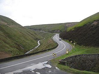
Like several other roads that cross the Pennines, Snake Pass has a poor accident record compared with roads in the UK generally, although more favourable compared with other roads in the area. It is regularly closed in winter because of snow, and has seen several longer-term closures owing to subsidence following heavy rain. The road remains a popular route for tourists and motorcycles, however, and sections have been used for semi-professional cycling races such as the Tour of Britain.

Route and location

The Pennine Way crosses Snake Pass at its summit. Pennine Way at A57 Snake Pass summit - geograph.org.uk - 22692.jpg
The Pennine Way crosses Snake Pass at its summit.

Snake Pass runs through the National Trust's High Peak Estate, and lies within the High Peak borough of Derbyshire; much of it falls within the Hope Woodlands parish, the remainder being within the Charlesworth parish. [1] [2] It is part of the shortest route by road from Manchester to Sheffield. [3]

The pass starts east of Glossop and climbs to the Pennines watershed between the moorland plateaux of Kinder Scout and Bleaklow to a high point of 1,680 feet (510 m) above sea level, where it crosses the Pennine Way. After this, it passes a public house that used to be known as the Snake Inn, and descends through forest to the Ladybower Reservoir at Ashopton. [1]

The name of the road matches its winding route, but actually derives from the emblem of the Snake Inn, one of the few buildings on the high stretch of road. In turn, the pub's name and sign were derived from the serpent on the Cavendish arms of William Cavendish, 6th Duke of Devonshire. [4] In the early 21st century, the inn was renamed the Snake Pass Inn, such that the inn now refers to the road that referred to itself. [4] [5]

History

The Snake Pass Inn was originally called the Snake Inn, but is now named after the pass itself, which in turn was named after the pub. Snake Pass Inn - geograph.org.uk - 5577.jpg
The Snake Pass Inn was originally called the Snake Inn, but is now named after the pass itself, which in turn was named after the pub.

An ancient road between Glossop and Ashopton was the Doctor's Gate, which follows the Shelf Brook between Shelf Moor and Coldharbour Moor. [6] It is marked on some maps as a Roman road, though this is disputed. [7] The route is now popular with walkers and mountain bikers. [8] In 1932, an Iron Age axe thought to be more than 2,000 years old was found near the site of this road. [9]

The current road further south was designed as a toll road by Thomas Telford [10] to improve communications east of Glossop, which was expanding as an industrial town. [11] It was originally called the Sheffield to Glossop Turnpike and run by a turnpike trust, the Sheffield and Glossop Trust. An act of parliament to build the road was passed in 1818, [lower-alpha 1] and construction was financed by the Duke of Norfolk and the Duke of Devonshire. [16] The road opened in 1821, [10] having cost £18,625 to build [16] (equivalent to £1.7 million in 2021 [17] ). Upon opening, it was the highest turnpike road in England. [18] The road was immediately popular and increased toll collections of traffic heading to Glossop. [19] Tolls were abolished on the road in June 1870. [20]

The eastern end of the pass is by the River Derwent. The river is bridged by the Ashopton Viaduct, built as part of the Ladybower Reservoir project between 1935 and 1945. [21]

Although Snake Pass is still the shortest route between Manchester and Sheffield, the more northerly Woodhead Pass, which is less steep and at a lower altitude, is now the primary road link between the two cities. [22] Unlike Snake Pass, the Woodhead route is a trunk road. [23] [24] [22] Traffic levels on both passes remained similar until the 1980s, [25] but the Woodhead Pass route is now favoured [24] as it connects directly to the M1, while Snake Pass leads into the centre of Sheffield.

Despite Sheffield and Manchester being among the largest UK cities by population, [26] there is no direct motorway link between the two. The M67 was originally proposed to be a Manchester to Sheffield motorway, but only a small section bypassing Denton and Hyde was actually built. [27] [28] The Woodhead Tunnel, which carried a Sheffield to Manchester railway line, was closed in 1981, and it was proposed to use it as part of a motorway link [29] but linking the cities by road would have meant constructing many costly tunnels and viaducts across the Peak District. Consequently, the plans were shelved, but reports in December 2014 announced a revival of the ambition for a road tunnel to avoid the passes. [30]

In 1979, the Department of Transport considered closing the road with traffic to be diverted to use the A628. [31]

The road remains popular with drivers. A 2008 survey by Caterham Cars rated Snake Pass the best driving road in the UK. [32] The following year, it was listed as one of the best roads for driving in Britain by Auto Trader magazine, who described it as "offering unparalleled views over Manchester". [33]

Safety

An abandoned car left hanging off the edge of Snake Pass, 1983 A57 - A dangerous road - geograph.org.uk - 616076.jpg
An abandoned car left hanging off the edge of Snake Pass, 1983

As would be expected for a road crossing the Pennines, Snake Pass has several dangerous bends and blind summits. [5] Like many roads in the North of England passing through similar terrain, Snake Pass has a poor safety record in comparison to other roads in the United Kingdom [34] but it is not as dangerous as other roads bisecting hilly terrain in this part of England. It was not among the top ten in lists of the most dangerous roads published by the Road Safety Foundation for EuroRAP in June 2007 and in July 2010, despite nine of the top ten being in Northern England. [35] [36]

In 2012, Derbyshire Police announced a campaign to monitor motorcyclists using the pass, who are particularly at risk of being involved in a fatal accident. [37]

Incidents of people being overtaken by bad weather in Snake Pass, and in particular the deaths of three walkers in 1964, led to the organisation of Peak District Mountain Rescue. [38]

Weather

Repair work to one of the highway's retaining walls, June 2015 Snake Pass retaining wall repairs.JPG
Repair work to one of the highway's retaining walls, June 2015

In winter the road is often the first of the routes between Sheffield and Manchester to be closed following snow in the area. [39] In bad storms the entire road over the summit, including marker poles, has been buried in snow. [18] Derbyshire County Council, who are the highway authority for Snake Pass, class the route as a priority for gritting [40] which is pre-treated ahead of icy weather. [41] The local borough council, High Peak Borough Council, who are not responsible for gritting, have stated that they would prefer streets in towns and villages were treated instead, as they believe that roads such as Snake Pass will be closed anyway. [42]

In 1924, Derbyshire County Council spent £2,000 (equivalent to £121,000 in 2021 [17] ) installing underground telegraph wire cables beneath the road, as the above-ground installations were continually broken and disrupted following snowstorms. [18] The British winter of 2010–11 was the coldest for decades and the road was closed on numerous occasions. [43] [44]

Subsidence

Snake Pass has also been closed for longer periods owing to subsidence in the local area following rain. In January 1932, the road was closed after 200 tonnes of debris fell on it during a heavy rainstorm, covering the surface in as much as 4 feet (1.2 m) in places. [45] In January 2008, a landslip at Cowms Moor following heavy rain caused the road to be closed to all traffic between Ladybower and Glossop, although access was still available to local premises and businesses including the Snake Pass Inn. [46] [47] A subsequent investigation by the British Geological Survey showed the road has had a history of subsidence-related long-term closures dating back to the 1930s, including a 1970s project that attempted to strengthen the layer below the tarmac with local rock fill. The road reopened in February, but with temporary traffic lights at the point of the slip restricting traffic to one direction at a time. [47] In 2012, the road had to be closed several times for resurfacing and strengthening. [48]

In February 2022, Snake Pass was closed to motor vehicles after Storm Eunice caused heavy rain leading to subsidence. Inspectors examining the road found three slumps in a single mile-long section. [49] Two weeks later, the closure was extended to bicycles, prompting protests; it was reopened on 31 March with weight restrictions and traffic light sections. [50] [51] That August, the council announced it would be partially closed again to investigate collapses, while the road would be examined with a drilling rig. [52] [53]

In May 2023, the road was closed again after Storm Franklin brought heavy rainfall to the region, causing landslips of up to 2 metres (6 ft 7 in). The closure extended from the turnoff at Fairholmes to the summit. [54]

Cycling and hiking

Snake Pass is a popular route for cyclists. A 1902 report on leisure cycling in the Lancashire Evening Post described the eastward journey from the summit to Ashopton as "nine miles unbroken freewheeling" and the scenery as "magnificent". [55] The road is one of only a few road climbs in the UK that are comparable in length and average gradient (approximately 7 per cent for around 3.2 miles (5.1 km) when starting in Glossop) to those used in continental cycle racing. [56] The road had been part of an 82-mile (132 km) "Tour of the Peak" race, involving climbing the pass twice, [57] and has frequently featured in the Tour of Britain along with another nearby favourite, Holme Moss. [56]

Cycling Time Trials sanctioned hill climbs are regularly promoted on this course by local club Glossop Kinder Velo. [58] The record for completing the course is 11 minutes 51 seconds, which was set by Tejvan Pettinger in 2014. [58] [59]

The annual Four Inns Walk has traditionally used parts of the route. [38]

Bus route

Hulleys of Baslow MCV Evora in Glossop on the final day of the X57 Snake service in January 2022 KTD HulleysOfBaslowEvOrA.jpg
Hulleys of Baslow MCV Evora in Glossop on the final day of the X57 Snake service in January 2022

Between October 2020 and January 2022, Hulleys of Baslow operated the X57 Snake bus route, which ran between Sheffield and Manchester via the Snake Pass. [60] The service was withdrawn on 9 January 2022 because low ridership made the route unsustainable. [61]

Snake Pass has been referred to several times by music groups. The track "The Snake" by Sheffield band The Human League, from their 2001 album Secrets , is about the road. [62] The Squarepusher album Selection Sixteen features a track entitled "Snake Pass", described by Rolling Stone as a "monomaniacal thump". [63]

Comic character John Shuttleworth has performed a song called "Incident on Snake Pass" about the perils of Snake Pass, [64] relating to an accident he claimed to have had, driving a Ford Anglia on the road. [65]

Notes

  1. 58 Geo. 3 c. xxxv, [12] [13] subsequently repealed and replaced in 1825 by 6 Geo. 4 c.xcviii, [14] itself replaced in 1851 by 14 & 15 Vict. c.cxxxiii, [15] An Act for repairing the road from Sheffield in the county of York to the Marple Bridge Road in the parish of Glossop in the county of Derby, and the branch to Mortimer's Road in the parish of Hathersage in the said county of Derby. The turnpike trust expired in 1875. [13]

Related Research Articles

<span class="mw-page-title-main">Peak District</span> Upland area in England


The Peak District is an upland area in England, at the southern end of the Pennines. Mostly in Derbyshire, it extends into Cheshire, Greater Manchester, Staffordshire, West Yorkshire and South Yorkshire. It is subdivided into the Dark Peak, moorland dominated by gritstone, and the White Peak, a limestone area with valleys and gorges. The Dark Peak forms an arc on the north, east and west of the district, and the White Peak covers central and southern areas. The highest point is Kinder Scout. Most of the area is within the Peak District National Park, a protected landscape designated in 1951.

<span class="mw-page-title-main">Glossop</span> Town in the High Peak, Derbyshire, England

Glossop is a market town in the borough of High Peak, in the county of Derbyshire, England. It is located 15 miles (24 km) east of Manchester, 24 miles (39 km) north-west of Sheffield and 32 miles (51 km) north of the county town, Matlock. Glossop lies near Derbyshire's borders with Cheshire, Greater Manchester, South Yorkshire and West Yorkshire. It is between 150 and 300 metres above sea level and is bounded by the Peak District National Park to the south, east and north. In 2021 it had a population of 33,340.

<span class="mw-page-title-main">Longdendale</span> Valley in England

Longdendale is a valley in the Peak District of England, north of Glossop and southwest of Holmfirth. The name means "long wooded valley" and the valley is mostly in the counties of Derbyshire and Greater Manchester.

<span class="mw-page-title-main">River Etherow</span> River in north west England

The River Etherow is a river in northern England, and a tributary of the River Goyt. Although now passing through South Yorkshire, Derbyshire and Greater Manchester, it historically formed the ancient county boundary between Cheshire and Derbyshire. The upper valley is known as Longdendale. The river has a watershed of approximately 30 square miles (78 km2), and the area an annual rainfall of 52.5 inches (1,330 mm).

<span class="mw-page-title-main">Mottram in Longdendale</span> Human settlement in England

Mottram in Longdendale is a village in Tameside, Greater Manchester, England. At the 2011 census, the population for the ward of Longdendale, which includes Mottram and the surrounding area, was 9,950.

<span class="mw-page-title-main">M67 motorway</span> Motorway in Greater Manchester, England

The M67 is a 5-mile (8.0 km) urban motorway in Greater Manchester, England, which heads east from the M60 motorway passing through Denton and Hyde before ending near Mottram. The road was originally conceived as the first section of a trans-Pennine motorway between Manchester and Sheffield that would connect the A57(M) motorway with the M1 motorway; however, the motorway became the only part to be built.

<span class="mw-page-title-main">A57 road</span> Road in England

The A57 is a major road in England. It runs east from Liverpool to Lincoln via Warrington, Salford and Manchester, and then through the Pennines over the Snake Pass (between the high moorlands of Bleaklow and Kinder Scout), around the Ladybower Reservoir, through Sheffield and past Worksop. Between Liverpool and Glossop, the road has largely been superseded by the M62, M602 and M67 motorways. Within Manchester a short stretch becomes the Mancunian Way, designated A57(M).

<span class="mw-page-title-main">Bamford</span> Human settlement in England

Bamford is a village in the Peak District, Derbyshire, England, close to the River Derwent. To the north-east is Bamford Edge, and to the north-west the Ladybower, Derwent and Howden Reservoirs. At the 2011 census, it had a population of 1,241.

<span class="mw-page-title-main">Hadfield, Derbyshire</span> Town in Derbyshire, England

Hadfield is a town in the High Peak of Derbyshire, England, with a population at the 2021 Census of 6,763. It lies on the south side of the River Etherow, near to the border with Greater Manchester, at the western edge of the Peak District close to Glossop. It doubled as the fictional town of Royston Vasey in the BBC comedy series The League of Gentlemen.

<span class="mw-page-title-main">Woodhead, Derbyshire</span> Human settlement in England

Woodhead is a small and scattered settlement at the head of the Longdendale valley in Derbyshire, England. It lies on the trans-Pennine A628 road connecting Greater Manchester and South Yorkshire, 6 miles (10 km) north of Glossop, 19 miles (31 km) east of Manchester and 18 miles (29 km) west of Barnsley. It is close to the River Etherow and the Trans Pennine Trail. Although part of Derbyshire since 1974, like nearby Tintwistle and Crowden, the hamlet was in the historic county of Cheshire.

<span class="mw-page-title-main">Woodhead line</span> Former Manchester to Sheffield railway line

The Woodhead line was a railway line linking Sheffield, Penistone and Manchester in the north of England. A key feature of the route is the passage under the high moorlands of the northern Peak District through the Woodhead Tunnels. The line was electrified in 1953 and closed between Hadfield and Penistone in 1981.

<span class="mw-page-title-main">Guide Bridge railway station</span> Railway station in Greater Manchester, England

Guide Bridge railway station serves Guide Bridge in Audenshaw, Greater Manchester, England, and is operated by Northern Trains. The station is 4+34 miles (7.6 km) east of Manchester Piccadilly on both the Rose Hill Marple and Glossop Lines.

<span class="mw-page-title-main">A635 road</span> Road in England

The A635 is a main road that runs between Manchester and Doncaster running east–west through Stalybridge, Saddleworth Moor, Holmfirth, Barnsley and the Dearne Valley. The section forming the eastern part of the Mancunian Way is a motorway and is officially designated as the A635(M) though there is no road sign with this designation, and the signs at the entrance of Mancunian Way westbound show A57(M).

<span class="mw-page-title-main">River Alport</span> River in England

The River Alport flows for 5.6 miles (9 km) in the Dark Peak of the Peak District in Derbyshire, England. Its source is on Bleaklow, 3 miles (4.8 km) east of Glossop, from which it flows south through the Grains in the Water bog, then over gritstone below the Alport Castles landslide to Alport Bridge on the A57 Snake Pass route from Sheffield to Manchester, where it joins the River Ashop. The Ashop flows into Ladybower Reservoir about 2.5 miles (4.0 km) down the valley, which discharges via the Rivers Derwent and Trent to the North Sea. The source of the Alport is close to the Pennine watershed.

<span class="mw-page-title-main">Longdendale Bypass</span> Future road in England

The Longdendale Bypass is a long-planned road scheme in England by the Highways Agency. The aim is to alleviate traffic congestion on the A57 road/A628 road/A616 road routes that presently pass through the villages. There is both support and opposition for this long-planned scheme which will pass through the valley of Longdendale and part of the Peak District National Park.

<span class="mw-page-title-main">A616 road</span> Road in England

The A616 is a road that links Newark-on-Trent, Nottinghamshire, to the M1 motorway at Junction 30, then reappears at Junction 35A and goes on to Huddersfield, West Yorkshire.

<span class="mw-page-title-main">A628 road</span> Road in Northern England

The A628 is a major road connecting Greater Manchester and South Yorkshire in northern England. It crosses the Pennine hills by way of Longdendale and the Woodhead Pass in the Peak District National Park. The road's altitude and exposure to bad weather create problems in winter and the road is sometimes closed due to snow or high winds.

<span class="mw-page-title-main">Padfield</span> Human settlement in England

Padfield is a small village near Hadfield in High Peak, Derbyshire, England. The village is on the west side of the Peak District National Park, and the nearest town is Glossop, where many local amenities and services are based. It is in a conservation area. The population as of the 2011 census was 2,796.

<span class="mw-page-title-main">Doctor's Gate</span> Roman Road between Glossop and the Hope Valley

Doctor's Gate is a Roman road in the Derbyshire Peak District of England, which ran between Melandra fort at Glossop and Navio fort at Brough-on-Noe. Doctor's Gate was recorded in 1627 as "Docto Talbotes Gate", named after Dr John Talbot who is attributed with improving the summit section in the late 15th century and 'gate' is derived from the Scandinavian word for road.

<span class="mw-page-title-main">X57 Snake</span> Bus route in England

The X57, often referred to as the Snake, was a bus route that ran between Manchester and Sheffield via Glossop.

References

  1. 1 2 The Peak District – Dark Peak Area (Map). 1:25 000. Ordnance Survey. 2010. OL 1.
  2. Cox, Barrie (1994). English Inn and Tavern Names. English Place Name Society. p. 36. ISBN   978-0-904889-42-0.
  3. Leadbetter, A. D. (January 1985). "3. A57 Snake Pass, remedial work to slip near Alport Bridge". In Institution of Civil Engineers (ed.). A57 Snake Pass, Remedial Work to Slip Near Alport Bridge . Thomas Telford. p. 29. doi:10.1680/fie.02432.0003. ISBN   978-0-7277-0243-2.{{cite book}}: |journal= ignored (help)
  4. 1 2 Dillon, Paddy (2011). The Pennine Way. Cicerone Press. p. 40. ISBN   978-1-84965-359-6.
  5. 1 2 Turner, Kevin (2012). Bonjour – Is This Italy?: A Hapless Biker's Guide to Europe. Veloce Publishing. p. 17. ISBN   978-1-84584-399-1. [...] the infamous Snake Pass, which as its name suggests, is a rather dangerous, serpentine route full of flowing bends and blind crests [...]
  6. Wroe, Peter (1982). "Roman roads in the Peak District" (PDF). Derbyshire Archaeological Journal. 102: 49–73.
  7. Taylor, G. G. (April 1983). "Doctor's Gate". Glossop Heritage. Glossop & District Historical Society. Retrieved 4 January 2020. For well over a century it has appeared on maps as a Roman road, and indeed still does, though some of us had been doubtful for many years.
  8. Vesey, Barbara, ed. (2000). The Hidden Places of England. Travel. p. 478. ISBN   978-1-902007-43-4.
  9. "Perfectly Shaped Axe Found near Shopton" . Derbyshire Times and Chesterfield Herald. 5 November 1932. Retrieved 27 March 2015 via British Newspaper Archive.
  10. 1 2 "SK 19 SW Parish of Hope Woodlands Snake Road 11/19 (South Side) Milestone II". National Heritage List for England . Historic England . Retrieved 4 January 2021. The Snake Pass was a toll road sanctioned by Act of Parliament in 1818 and opened in 1821, Thomas Telford engineer.
  11. "John Overend Todd Archive: Howard of Glossop Estate". National Archives. Retrieved 26 March 2015.
  12. "Chronological Tables of Local Acts (1816–1818)". legislation.gov.uk . Retrieved 6 January 2021.
  13. 1 2 Rosevear, Alan (2 September 2017). "List of Turnpike Trusts in England". Turnpike Roads in England and Wales. Retrieved 14 January 2021.
  14. "Chronological Tables of Local Acts (1825)". legislation.gov.uk . Retrieved 6 January 2021.
  15. "Chronological Tables of Local Acts (1851)". legislation.gov.uk . Retrieved 6 January 2021.
  16. 1 2 Albert, William (2007). The Turnpike Road System in England: 1663–1840. Cambridge University Press. p. 105. ISBN   978-0-521-03391-6.
  17. 1 2 UK Retail Price Index inflation figures are based on data from Clark, Gregory (2017). "The Annual RPI and Average Earnings for Britain, 1209 to Present (New Series)". MeasuringWorth. Retrieved 11 June 2022.
  18. 1 2 3 "Town and County Gossip" . Derby Daily Telegraph . 1 November 1924. p. 3. Retrieved 27 March 2015 via British Newspaper Archive.
  19. "Turpike Tolls to let" . Sheffield Independent. 4 May 1822. p. 3. Retrieved 27 March 2015 via British Newspaper Archive.
  20. "Local Turnpikes Case" . Sheffield Independent. 8 May 1883. p. 2. Retrieved 27 March 2015 via British Newspaper Archive.
  21. "To Be Opened By H.M. The King: Full Description of the Ladybower Reservoir" . Derbyshire Times and Chesterfield Herald. 21 September 1945. p. 7 via British Newspaper Archive.
  22. 1 2 "Woodhead Pass". Roader's Digest: The SABRE Wiki. Retrieved 4 January 2021. The [Woodhead Pass] crossing replaced the A57 Snake Pass in the early 20th Century, being less arduous. Indeed, the route is mostly made up of more gentle gradients and curves than the Snake Pass [...] the A628 being the major route between Manchester and Sheffield [...]
  23. "Network Management Map" (PDF). Highways England. January 2020.
  24. 1 2 "A628". Roader's Digest: The SABRE Wiki. Retrieved 4 January 2021.
  25. Chalker, Lynda (19 March 1984). "Woodhead Route". Parliamentary Debates (Hansard) . Vol. 56. House of Commons. col. 335W. Retrieved 4 January 2021. A628: August 1973. 4,000 vehicles per day [...] July 1983. 4,000 vehicles per day [...] A57: August 1973. 4,800 vehicles per day [...] April 1981. 3,500 vehicles per day
  26. Champion, Tony (June 2014). People in cities: the numbers (PDF) (Report). Government Office for Science. p. 53. Retrieved 3 April 2015.
  27. "Sheffield – Manchester route would be first major cross-Pennines link since M62". ITV News Calendar . The original plan – half a century ago – was that the M67 would be the start of a trans-Pennine motorway linking Manchester with the M1 in South Yorkshire.
  28. "M67 Hyde By-pass and Denton Relief Road". UK Motorways Archive. Chartered Institution of Highways & Transportation. It was the intention that, in due course, the motorway would be extended as an improved route through to Sheffield.
  29. Marshall, Chris. "M67". Roads.org.uk. Retrieved 5 January 2020. The main rail line between Sheffield and Manchester [...] was run into ruin by the Department of the Environment with the intention that its tunnel could be used as an all-weather route for the motorway through the most mountainous section. It was only when one of the best intercity lines in the country had been fully closed that [...] the new motorway route was subsequently scrapped.
  30. "Sheffield to Manchester £6bn road tunnel 'plan' announced". BBC News . 1 December 2014. Retrieved 27 March 2015.
  31. "Snake Pass to close?". Commercial Motor . 7 September 1979. p. 18.
  32. "Snake Pass is voted best road". The Star . Sheffield. 16 September 2008. Archived from the original on 2 April 2015. Retrieved 27 March 2015.
  33. "England's best driving road – revealed". Auto Trader . 23 April 2009. Archived from the original on 12 March 2012.
  34. Bond, Lucy (15 November 2018). "These are some of the most dangerous roads in the UK during winter". The Snake Pass, which has a poor accident record [...] was once the main signposted route between Manchester and Sheffield, but authorities have since thought better of directing traffic towards this treacherous trail, which is particularly vulnerable to snow and subsidence.
  35. "'Most dangerous' roads in Britain named by safety group". BBC News. 1 July 2010. Retrieved 4 July 2011.
  36. "Britain's most dangerous roads". BBC News. 25 June 2007.
  37. "Police in bid to reduce Snake Pass road deaths". Manchester Evening News. 5 April 2012. Retrieved 26 March 2015.
  38. 1 2 Harby, Jennifer (28 August 2021). "The tragedy that saw the birth of the Peak District mountain rescue teams". BBC News. Retrieved 14 August 2022.
  39. Nuttall, John; Nuttall, Anne (1990). Mountains of England and Wales. Cicerone Press. p. 293. ISBN   978-1-85284-037-2.
  40. "Gritting routes". Derbyshire County Council . Retrieved 4 January 2021.
  41. Beckett, Paul; Terry, Bronwen (November 2020). "Winter Service Plan" (PDF). Derbyshire County Council . p. 11.
  42. Environment Select Committee Meeting (PDF) (Report). High Peak Borough Council. 16 February 2010. p. 2. Archived from the original (PDF) on 4 March 2016. Retrieved 27 March 2015. [...] it was suggested that [...] resources be diverted to ensure roads through towns and villages were passable, with less emphasis on roads such as the Snake Pass and Cat & Fiddle road which will inevitably be closed.
  43. "Derbyshire hit by road and school closures over snow". BBC News. 2 December 2010. Retrieved 9 July 2011. The A57 Snake Pass is closed in both directions between the Hurst Road junction in Glossop and the A6013.
  44. Carr, Sue (17 December 2010). "Snake Pass closed as snow returns". Manchester Evening News. Retrieved 3 April 2015.
  45. "Landslide on the Snake" . Derbyshire Times and Chesterfield Herald. 9 January 1932. p. 12 via British Newspaper Archive.
  46. "Traffic Alert: Landslide closes A57". Sheffield Telegraph . 25 January 2008. Archived from the original on 4 March 2016. Retrieved 26 March 2015. The Snake Pass [...] is closed until further notice because of a landslide following heavy rain earlier this week. [...] Access to the Snake Pass Inn is still possible.
  47. 1 2 Walkover survey of a landslide on the A57 (Snake Pass) road at Cowms Moor, Derbyshire in January 2008 (PDF) (Report). British Geological Survey. 16 May 2008. Retrieved 26 March 2015.
  48. "Snake Pass to close for three weekends". Manchester Evening News. 29 October 2012. Retrieved 26 March 2015.
  49. "Snake Pass: Peak District A57 shut for at least a month". BBC News. 23 February 2022. Retrieved 1 March 2022.
  50. Watson, Greig (29 March 2022). "A57 Snake Pass: Road to reopen with weight limit". BBC News. Retrieved 14 August 2022.
  51. Ochnio, Dominik (31 March 2022). "Snake Pass has been reopened with new restrictions". Shef News. Retrieved 14 August 2022.
  52. "A57 Snake Pass to close for investigation into landslip". BBC News. 17 August 2022. Retrieved 18 August 2022.
  53. Harby, Jennifer (26 September 2022). "Snake Pass to close for landslip investigation". BBC News. Archived from the original on 26 September 2022. Retrieved 26 September 2022.
  54. "A57 Snake Pass: Landslip repairs will see road shut for five days". BBC News. 15 May 2023. Retrieved 22 May 2023.
  55. "Cycling Notes by Ixion" . Lancashire Evening Post. 3 December 1902. p. 4. Retrieved 27 March 2015 via British Newspaper Archive.
  56. 1 2 Jones, Tom (2013). Mad Dogs and Englishmen: A Year of Things to See and Do in England. Random House. p. 50. ISBN   978-0-7535-4957-5. [...] one of only a few roads that can compete with the hill stages of Alpine cycling [...]
  57. "Cycling : Despatch from "Clubman"" . Lichfield Mercury. 18 June 1943. p. 3. Retrieved 27 March 2015 via British Newspaper Archive.
  58. 1 2 "Snake Pass Hill Climb". Glossop Kinder Velo. Retrieved 4 January 2020.
  59. "Tejvan Pettinger wins Glossop Kinder Velo hill-climb". Cycling Weekly . 31 August 2014. Retrieved 27 March 2015.
  60. Cumber, Robert (16 September 2020). "New Sheffield-Manchester bus route across Peak District could be country's most picturesque". The Star. Sheffield. Retrieved 2 October 2020.
  61. Kessen, David (26 November 2021). "Sheffield to Manchester bus route via Snake Pass to be withdrawn in the New Year". The Star. Sheffield. Retrieved 20 January 2023.
  62. Smith, Mike (21 July 2012). "Taking the High Road from Glossop to Ladybower". Derbyshire Life and Countryside. Archant Community Media. Retrieved 4 January 2021 via Great British Life. The fame of the Snake Pass has spread well beyond the Peak District [...] the Human League even wrote a song about it, featuring the refrain: 'Come and join us/Come and join us/From the valley to the hillside/From the upside to the down'.
  63. Brackett, Nathan; Hoard, Christian David, eds. (2004). The New Rolling Stone Album Guide . Simon and Schuster. p.  773. ISBN   978-0-7432-0169-8. [...] only the monomaniacal thump of "Snake Pass" delivers the goods.
  64. Walters, Sarah (26 January 2017). "Review: John Shuttleworth at The Lowry". Manchester Evening News .
  65. Blackwell, Holly (20 October 2010). "Shuttleworth's on a roll". The Visitor . Archived from the original on 4 March 2016. Retrieved 28 March 2015. I had the incident on the Snake Pass in the Ford Anglia.