
The Derwent is a river in Derbyshire, England. It is 66 miles (106 km) long and is a tributary of the River Trent, which it joins south of Derby. Throughout its course, the river mostly flows through the Peak District and its foothills.

The River Etherow is a river in northern England, and a tributary of the River Goyt. Although now passing through South Yorkshire, Derbyshire and Greater Manchester, it historically formed the ancient county boundary between Cheshire and Derbyshire. The upper valley is known as Longdendale. The river has a watershed of approximately 30 square miles (78 km2), and the area an annual rainfall of 52.5 inches (1,330 mm).

The Howden Reservoir is a Y-shaped reservoir, the uppermost of the three in the Upper Derwent Valley, England. The western half of the reservoir lies in Derbyshire and the eastern half is in Sheffield, South Yorkshire; the county border runs through the middle of the reservoir, following the original path of the River Derwent. The longest arm is around 1.25 miles (2 km) in length. The reservoir is bounded at the southern end by Howden Dam; below this, the Derwent flows immediately into Derwent Reservoir and subsequently the Ladybower Reservoir. Other tributaries include the River Westend, Howden Clough and Linch Clough.
The River Dane is a tributary of the River Weaver that originates in the Peak District area of England. The name of the river is probably from the Old Welsh dafn, meaning a "drop or trickle", implying a slow-moving river.
The River Wye is a limestone river in the Peak District of Derbyshire, England. It is 22 miles in length, and is one of the major tributaries of the River Derwent, which flows into the River Trent, and ultimately into the Humber and the North Sea.

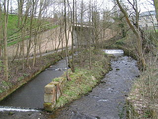
The River Noe is a tributary of the River Derwent in Derbyshire, England. It flows approximately 12 miles (19 km) from its source, the confluence of two streams running off Kinder Scout in the Peak District, east through Edale and then southeast through the village of Hope.

The A57 is a major road in England. It runs east from Liverpool to Lincoln via Warrington, Cadishead, Irlam, Patricroft, Eccles, Salford and Manchester, then through the Pennines over the Snake Pass, around the Ladybower Reservoir, through Sheffield and past Worksop. Within Manchester a short stretch becomes the Mancunian Way.

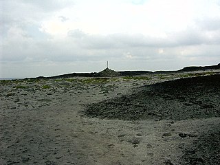
Kinder Scout is a moorland plateau and national nature reserve in the Dark Peak of the Derbyshire Peak District in England. Part of the moor, at 636 metres (2,087 ft) above sea level, is the highest point in the Peak District, the highest point in Derbyshire, and the highest point in the East Midlands. In excellent weather conditions the city of Manchester and the Greater Manchester conurbation can be seen, as well as Winter Hill near Bolton, and the mountains of Snowdonia in North Wales.

The Hope Valley is a rural area centred on the village of Hope, Derbyshire in the Peak District in the northern Midlands of England.

The River Bollin is a major tributary of the River Mersey in the north-west of England.
The River Wyre is a river in Lancashire, England, United Kingdom, which flows into the Irish Sea at Fleetwood. It is approximately 28 miles (45 km) in length. The river is a County Biological Heritage Site and has a sheltered estuary which, from its northwest corner, penetrates deep into the almost square peninsula of the Fylde.

The River Dove is the principal river of the southwestern Peak District, in the Midlands of England and is around 45 miles (72 km) in length. It rises on Axe Edge Moor near Buxton and flows generally south to its confluence with the River Trent at Newton Solney. From there, its waters reach the North Sea via the Humber Estuary. For almost its entire course it forms the boundary between the counties of Staffordshire and Derbyshire. The river meanders past Longnor and Hartington and cuts through a set of stunning limestone gorges, Beresford Dale, Wolfscote Dale, Milldale and Dovedale.
Bleaklow is a high, largely peat-covered, gritstone moorland, just north of Kinder Scout, across the Snake Pass (A57), in the Derbyshire High Peak near the town of Glossop. Much of it is nearly 2,000 feet (610 m) above sea level and the shallow bowl of Swains Greave on its eastern side is the source of the River Derwent.

The River Worth is a river in West Yorkshire, England. It flows from minor tributaries on the moors above Watersheddles Reservoir down the Worth Valley to Haworth, where it is joined by Bridgehouse Beck which flows from Oxenhope. The River Worth is itself a tributary of the River Aire, which it joins at the end of the Worth Valley in Keighley.

The River Dean rises at Longclough in Macclesfield Forest on the western edge of the Peak District foothills above the village of Rainow in north east Cheshire, England.

The River Hyndburn is a minor river in Lancashire, England. Beginning as Woodnook Water on the slopes of Goodshaw Hill, it passes through Stone Fold, Rising Bridge and Baxenden where it is augmented by streams from Thirteen Stone Hill and continues to the Woodnook area of Accrington. Near St James Church, it collects Broad Oak Water, becoming the River Hyndburn.
The River Sett is a river that flows through the High Peak borough of Derbyshire, in north western England. It rises near Edale Cross on Kinder Scout and flows through the villages of Hayfield and Birch Vale to join the River Goyt at New Mills. The River Goyt is one of the principal tributaries of the River Mersey. In the past, the river was known as the River Kinder; the modern River Kinder is a right tributary of the Sett, joining the river at Bowden Bridge above Hayfield.

The River Calder is a major tributary of the River Ribble in Lancashire, England and is around 20 miles (32 km) in length.

The River Alport flows for 5.6 miles (9 km) in the Dark Peak of the Peak District in Derbyshire, England. Its source is on Bleaklow, 3 miles (4.8 km) east of Glossop, from which it flows south through the Grains in the Water bog, then over gritstone below the Alport Castles landslide to Alport Bridge on the A57 Snake Pass route from Sheffield to Manchester, where it joins the River Ashop. The Ashop flows into Ladybower Reservoir about 2.5 miles (4.0 km) down the valley, which discharges via the Rivers Derwent and Trent to the North Sea. The source of the Alport is close to the Pennine watershed.

The River Alwin is a short, steep upland river that drains the Kidland Forest on the southern flanks of the Cheviot Hills, in the Northumberland National Park, England. It is a tributary of the River Coquet and 2.7 miles (4.3 km) in length.

