This article may need to be rewritten to comply with Wikipedia's quality standards.(July 2024) |
Ilkeston | |
---|---|
Ilkeston Market Place (August 2003) | |
Location within Derbyshire | |
Population | 38,640 (2011) [1] |
Demonym | Ilkestonian [2] [3] |
OS grid reference | SK 46399 41774 |
District | |
Shire county | |
Region | |
Country | England |
Sovereign state | United Kingdom |
Areas of the town | List
|
Post town | ILKESTON |
Postcode district | DE7 |
Dialling code | 0115 |
Police | Derbyshire |
Fire | Derbyshire |
Ambulance | East Midlands |
UK Parliament | |
Ilkeston is a town in the Borough of Erewash, Derbyshire, England, on the River Erewash, from which the borough takes its name, with a population at the 2011 census of 38,640. [4] Its major industries, coal mining, iron working and lace making/textiles, have now all but disappeared.
The town is close to both Derby and Nottingham and is near the M1 motorway and the border with Nottinghamshire. The eastern boundary of Ilkeston is only two miles from Nottingham's western edge and it is part of the Nottingham Urban Area.
Ilkeston was likely founded during the 6th century, and gets its name from its supposed founder Elch or Elcha, who was an Anglian chieftain. The town appears as Tilchestune in the Domesday Book of 1086, when it was owned principally by Gilbert de Ghent. Gilbert also controlled nearby Shipley, West Hallam and Stanton by Dale. [5] Ilkeston was created a borough by Queen Victoria in 1887.
Ilkeston is one of several places where the distinctive dialect of East Midlands English is extensively spoken. Ilkeston is referred to as 'Ilson' in this dialect. [6] Generally the name is pronounced with three syllables, Ilkisstun, not Ilk's tun.
The American Adventure, a large theme park which closed in 2007, was located on the outskirts of Ilkeston on the former Woodside Colliery adjoining Shipley Country Park.
NatWest's Ilkeston branch gained much media interest when a hole in a neighbouring wall received an influx of reviews on Tripadvisor, causing them to suspend reviews in February 2020. [7]
One of the biggest and most important local employers was the Stanton Ironworks, later known as Stanton and Staveley – the continuation of a long-standing tradition of iron working in this area. There has been evidence of iron working and quarrying in the area since Roman times, and the industry began blossoming into a huge industrial concern in the 1780s. By the mid-19th century there were several blast furnaces and the production rose from around 500 tons of pig iron per month to 7,000 at the end of the century. The Stanton Ironworks acquired a number of smaller ironstone quarrying and ironworks companies. These included the Wellingborough Iron Company in 1932. [8]
Steel pipe manufacturing began at Stanton after World War I and later concrete pipes were produced, Stanton being the first in the UK to develop the 'spun pipe' process.
In the mid-19th century the works produced 20,000 tons of iron castings per year, 2.5 millions by 1905. Up to 12,500 people were employed during the period when the works were part of British Steel Corporation, of which 7,000 worked at the Stanton works. [9] [10]
During its long existence the works produced huge quantities of a variety of products, including pig iron, tunnel castings, (used in projects such as the London Underground), pipes and street furniture as well as bitumen, roadstone, chemicals and munition casings.
The works gradually declined, the business being run from 1985 by the French Saint-Gobain Group. The last casting was an emotional event in 2007. [11] The huge Stanton site has been partially given over to business park and the rest of the site is earmarked for redevelopment which is subject to local opposition. [12]
Ilkeston Market Place is the site of a Charter fair. [13] The fair celebrated its 770th anniversary in 2022, the Charter being granted by King Henry III in 1252. This makes the fair older than Nottingham's famous Goose Fair and it is one of the largest street fairs in the Country, indeed in Europe.
The present fair developed from two separate fairs, as another 'agricultural hiring fair' or 'Statutes Fair' was traditionally held on Wakes week in October as well as the original Charter Fair which was held on the Feast of the Assumption of the Blessed Virgin Mary (15 August). The two fairs were combined in 1888 and the one Charter Fair has been held in October ever since.
Since 1931 the fair has been officially opened by the Mayor - first of Ilkeston and since 1974 of Erewash - on the Fair Thursday at noon with the Town Clerk (Chief Executive) reading the Charter from the steps of the Town Hall.
Ilkeston did not have a railway station from 1967 to 2017, despite its substantial population and the fact that the Erewash Valley Line (formerly part of the Midland Railway, later the LMS) skirts the eastern edge of the town. Ilkeston once had three railway stations. Ilkeston Junction station, also known as "Ilkeston Junction & Cossall" was on the former Midland Railway and later LMS Erewash Valley Main Line: this station closed in January 1967. A short branch led from this station to Ilkeston Town station, at the north end of Bath Street, which closed to passengers in June 1947.
Ilkeston's third station was Ilkeston North, on the former Great Northern Railway (later LNER) line from Nottingham to Derby Friargate station, closed in September 1964. A major feature of this line was Bennerley Viaduct, a 1,452-foot (443 m) long, 61-foot (19 m) high, wrought iron structure which still crosses the Erewash valley just to the north east of Ilkeston. Once threatened with demolition, it is now a Grade 2 listed building, though the line and embankments have long since been removed. The Viaduct has been the subject of much renewed interest and has been reopened to the public as part of a cycleway and footpath. [14]
Following a long-running local campaign, in March 2013 Transport Secretary Patrick McLoughlin announced that Ilkeston was one of three sites 'most likely' to get a new station as part of the 'New Stations Fund', costing £5 million and sited close to the old Ilkeston Junction station. [15] On 15 May 2013 it was announced this new station would be built, which would be named Ilkeston station. It has two platforms, which can take six trains per hour with up to six passenger cars and includes waiting shelters. A 150 space car park, cycle storage, bus stop, drop off point and taxi rank are also on site. The station is unmanned with automated ticket machines.
Due to flood prevention work and the discovery of great crested newts, the opening was significantly delayed, the new station opened on 2 April 2017. [16]
TrentBarton operate the majority of buses around Ilkeston including the Ilkeston Flyer into Derby, My15 to Long Eaton and East Midlands Airport, The Two into Nottingham, 31 to Kirk Hallam, 32 to Derby, 33 to Mansfield, and 34/35 into Hucknall. [17] [18] Notts + Derby and CT4N operate some Derbyshire County Council tendered routes around Ilkeston. [19]
From early in the 19th century the existence of natural mineral waters was noted here and exploited. A local businessman Thomas Potter built, in 1831, the famous Ilkeston Bath at the bottom of Town Street attached to the Rutland Hotel. [20] For over 60 years the baths helped tourism to the town at a time when spa towns like Bath and Harrogate enjoyed popularity. 'If you're doubled in pain and thin as a lath, Come at once then and try, the famed Ilkeston Bath,' was a well known advertising slogan. A mixture of a general decline in the popularity of spa bathing and, reportedly, contamination of the waters from mining activities led to the eventual closure of the baths just before 1900. The baths and the adjacent Rutland Hotel, which also enjoyed a revenue from tourism, no longer exist though they are remembered in the name of 'Bath Street'.
First-Class County games
Every season between 1925 and 1994, the Derbyshire County Cricket Club played up to a couple of first-class cricket matches on the Rutland Recreation Ground, and one-day matches between 1970 and 1994.
Local news and television programmes are BBC East Midlands and ITV Central. Television signals are received from the Waltham TV transmitter, [37] and the Nottingham relay transmitter. [38]
The town is served by both BBC Radio Nottingham on 103.8 FM and BBC Radio Derby on 104.5 FM. Other radio stations including Smooth East Midlands on 106.6 FM, Capital East Midlands on 96.2 FM, Greatest Hits Radio Midlands on 106.6 FM and Erewash Sound, a community based radio station on 96.8 FM. [39]
The town is served by these newspapers:
Ilkeston is twinned with:
Long Eaton is a town in the Erewash district of Derbyshire, England, just north of the River Trent, about 6 miles (9.7 km) south-west of Nottingham and 9 miles (14 km) south-east of Derby. The town population was 37,760 at the 2011 census. It has been part of Erewash borough since 1 April 1974, when Long Eaton Urban District was disbanded.
Erewash is a local government district with borough status in Derbyshire, England. The borough is named after the River Erewash. The council has offices in both the borough's towns of Ilkeston and Long Eaton. The borough also includes several villages and surrounding rural areas. Some of the built-up areas in the east of the borough form part of the Nottingham Urban Area.
West Hallam is a large village and civil parish close to Ilkeston in the county of Derbyshire in the East Midlands region of England. West Hallam has had its own parish council since 1894 and, since 1974, has been part of the Erewash borough. The population of the civil parish was 4,829 at the 2001 census reducing to 4,686 at the 2011 census.
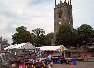
Sandiacre is a village and civil parish in the borough of Erewash in Derbyshire, in the East Midlands region of England adjoining the border with Nottinghamshire. The population of the parish was 8,889 at the 2011 Census.
The Nottingham Built-up Area (BUA), Nottingham Urban Area, or Greater Nottingham is an area of land defined by the Office for National Statistics as built-up land with a minimum area of 20 hectares, while settlements within 200 metres of each other are linked. It consists of the city of Nottingham and the adjoining urban areas of Nottinghamshire and Derbyshire, in the East Midlands of England. It had a total population of 729,977 at the time of the 2011 census. This was an increase of almost 10% since the 2001 census recorded population of 666,358, due to population increases, reductions and several new sub-divisions.
Erewash is a constituency in Derbyshire represented in the House of Commons of the UK Parliament since 2024 by Adam Thompson of Labour.
Risley is a small village and parish in the Borough of Erewash in Derbyshire, England. The population of the civil parish as of the 2011 census was 711. It is four miles south of Ilkeston.
Langley Mill is a village in the civil parish of Aldercar and Langley Mill in the Amber Valley district of Derbyshire, England.
The Derbyshire and Staffordshire extension of the Great Northern Railway was an English railway network built by the GNR to get access to coal resources in the area to the north and west of Nottingham. The Midland Railway had obstructed the GNR in its attempts to secure a share of the lucrative business of transporting coal from the area, and in frustration the GNR built the line. The line was forked: it reached Pinxton in 1875 and a junction with the North Staffordshire Railway at Egginton, approaching Burton on Trent in 1878. The line cut through Derby, resulting in considerable demolition of housing there.
The Erewash Valley Line is a railway line in England, running from Long Eaton, located between Nottingham and Derby, and Clay Cross, near Chesterfield. The southern part was opened by the Midland Railway in 1847 as far as Codnor Park, where it connected to established ironworks, and soon after, a line to Pinxton and Mansfield.
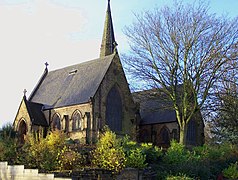
Breadsall is a village and civil parish in the Borough of Erewash in Derbyshire, England. The population of the village at the 2021 census was 792 Breadsall Priory is one of the oldest buildings in the village. The village is almost contiguous with both Derby to the south and southeast and Little Eaton to the north.
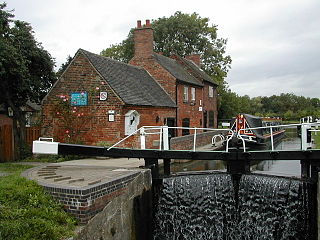
The Nutbrook Canal was a canal in England which ran between Shipley in Derbyshire and the Erewash Canal, joining it near Trowell. It was built to serve the collieries at Shipley and West Hallam, and was completed in 1796. It was initially profitable, but from 1846 faced competition from the railways, and more seriously, subsidence caused by the coal mines that it was built to serve. With the mines failing to pay tolls for goods carried on the canal, and in some cases refusing to accept responsibility for the subsidence, most of it was closed in 1895, although the final 1.5 miles (2.4 km) remained in use until 1949.
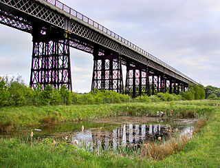
Bennerley Viaduct is a former railway bridge, now a foot and cycle bridge, between Ilkeston, Derbyshire, and Awsworth, Nottinghamshire, in central England. It was completed in 1877 and carried the Great Northern Railway's (GNR) Derbyshire Extension over the River Erewash, which forms the county boundary, and its wide, flat valley. The engineer was Samuel Abbott, who worked under Richard Johnson, the GNR's chief engineer. The site required a bespoke design as the ground would not support a traditional masonry viaduct due to extensive coal mining. The viaduct consists of 16 spans of wrought iron, lattice truss girders, carried on 15 wrought iron piers which are not fixed to the ground but are supported by brick and ashlar bases. The viaduct is 60 feet high, 26 feet wide between the parapets, and over a quarter of a mile long. It was once part of a chain of bridges and embankments carrying the railway for around two miles across the valley but most of its supporting structures were demolished when the line closed in 1968. The only similar surviving bridge in the United Kingdom is Meldon Viaduct in Devon.
Borrowash is a village in the Erewash district of Derbyshire, England, situated immediately east of the Derby city boundary. The appropriate civil parish is called Ockbrook and Borrowash.
Stanton by Dale, also written as Stanton-by-Dale, is a village and civil parish in the south east of Derbyshire, England. According to the University of Nottingham English Place-names project, the settlement name Stanton-by-Dale could mean 'Stony farm or settlement', stān for stone or rock; and tūn for an enclosure; farmstead; village; or an estate. It lies 2.65 miles (4.26 km) south of Ilkeston and 1.31 miles (2.11 km) north of Sandiacre. Since 1974 it has been part of the Erewash borough. The village is halfway between the cities of Derby 6.98 miles (11.23 km) and Nottingham 6.81 miles (10.96 km), as the crow flies, from each city. The population of the civil parish at the 2011 census was 505.
Ilkeston North railway station was a railway station in Ilkeston, Derbyshire. It was opened by the Great Northern Railway on its Derbyshire Extension in 1878 and closed in 1964.
Ilkeston Town Hall is a municipal building in the Market Place, Ilkeston, Derbyshire. The town hall, which currently serves as one of two meeting places of Erewash Borough Council, is a Grade II listed building.
Ilkeston railway station serves the town of Ilkeston, Derbyshire, England. It is located at the site of the former Ilkeston Junction and Cossall station, on the Midland Main Line between Nottingham and Langley Mill. It is served by Northern Nottingham to Leeds services and by East Midlands Railway.
Nutbrook Cricket Club is an amateur cricket club on the eastern boundary of West Hallam, Derbyshire, England. The club has a history dating back to 1937.
Ilkeston Rutland Cricket Club is an amateur cricket club based in Ilkeston, Derbyshire, England. The club has a history dating back to 1824.