Ashbourne, Derbyshire

Last updated

Ashbourne
Asbourne St Oswold 001.JPG
St Oswald's Church, the parish church of Ashbourne and a grade I listed building.
Derbyshire UK location map.svg
Red pog.svg
Ashbourne
Location within Derbyshire
Population8,377 (Parish, 2011) [1]
OS grid reference SK1846
Civil parish
  • Ashbourne
District
Shire county
Region
Country England
Sovereign state United Kingdom
Post town ASHBOURNE
Postcode district DE6
Dialling code 01335
Police Derbyshire
Fire Derbyshire
Ambulance East Midlands
UK Parliament
List of places
UK
England
Derbyshire
53°00′58″N1°43′52″W / 53.016°N 1.731°W / 53.016; -1.731
Ashbourne Town Hall and town centre Market Hall, Ashbourne - geograph.org.uk - 335763.jpg
Ashbourne Town Hall and town centre

Ashbourne is a market town in the Derbyshire Dales district in Derbyshire, England. Its population was measured at 8,377 in the 2011 census [2] and was estimated to have grown to 9,163 by 2019. [3] It has many historical buildings and independent shops. The town offers a historic annual Shrovetide football match. Its position near the southern edge of the Peak District makes it the closest town to Dovedale, to which Ashbourne is sometimes referred to as the gateway.

Contents

The town is 14 miles (23 km) west of Derby, 21 miles (34 km) south-east of Buxton, 22 miles (35 km) east of Stoke-on-Trent, 49 miles (79 km) south-south-east of Manchester, 35 miles (56 km) south-west of Sheffield and 27 miles (43 km) north of Lichfield. Nearby towns include Matlock, Uttoxeter, Leek, Cheadle and Bakewell.

History

The town's name derives from the Old English æsc-burna meaning "stream with ash trees". [4]

Ashbourne was granted a market charter in 1257. [5] In medieval times it was a frequent rest stop for pilgrims walking "St Non's Way" to the shrine of Saint Fremund at Dunstable in Bedfordshire. [6]

The forces of Charles Edward Stuart passed through Ashbourne during the Jacobite rising of 1745. [7]

Governance

Ashbourne Town Council has four wards – Belle Vue, Hilltop, Parkside and St Oswald's – represented by a total of 13 councillors. It meets at Ashbourne Town Hall in the Market Place. [8]

Geography

Ashbourne lies at 53°01′N01°44′W / 53.017°N 1.733°W / 53.017; -1.733 . Ashbourne Green and Sturston are hamlets close by. Henmore Brook, a tributary of the River Dove, flows through the middle of the town. It has an elevation of 400 feet (122 m). [9]

Economy

From 1910, Nestlé had a creamery in the town which, for a period, was contracted to produce Carnation condensed milk. The factory had its own private sidings connected to the railway station goods yard, which allowed milk trains to access the facility and distribute product as far south as London. After milk trains ceased in 1965, the railway track was lifted as passenger services and the railway station had already been closed back in 1954. The factory closed in 2003 and, since demolition in 2006, has been redeveloped as housing and a light industrial estate, although the old loading ramp from street level up to the factory floor is still in place.

Water from a borehole on the site was first marketed as Ashbourne Water in 1975 and was sold mostly to the catering trade. [10] Nestlé retained the borehole after the factory shut, taking water by tanker to Buxton for bottling. [10] Declining sales (1.3 million bottles in 2005, compared to 90 million for Buxton water) meant it could not justify further investment and the brand was discontinued in 2006. [10]

Tourism is an important element of the local economy, due to the town's proximity to Dovedale and the Peak District. The Tourist Information Centre was closed in 2011 [11] but, from January 2018, a visitor information centre was made available again in the town hall. [12]

Culture and community

Ashbourne Library Ashbourne Library - Compton Street, Ashbourne (15123295970).jpg
Ashbourne Library

The cobbled market place hosts a traditional outdoor market every Thursday and Saturday throughout the year, complementing the wide range of individual shops in the town. Although its market heritage is important, it came under threat of closure from Derbyshire County Council in November 2012. The people of Ashbourne opposed any such moves by the council and started an online petition. Ashbourne became the 97th Fairtrade Town in March 2005 after many businesses, cafes, shops and community organisations started supporting Fairtrade. [13]

Ashbourne Shire Horse Society and Show

According to the Ashbourne Show website: [14]

"In 1881, four gentlemen founded a society aimed at improving the standard of Shire horses in the Ashbourne area. Originally known as the Ashbourne Cart Horse Society, later that year, it held its first a show on the Paddock, at Ashbourne. This was so successful, it was determined by public meeting to put it on a permanent basis. Apart from a few years lost to war and foot-and-mouth, an annual show has been held ever since. In 1888, the title Ashbourne Shire Horse Society was adopted and royal patronage was granted in 1899 by King Edward VII, who was President in 1901. Shrovetide Football although much older, did not become royal till 1928. Although there have been ups and downs, the ambition of the founders has been fully justified. It has grown, changed and evolved, with cattle introduced in 1925 and sheep in 1957. Other sections have also been added, so that it has become the modern Ashbourne Show, now presented by the Ashbourne Shire Horse Society. However, what has not changed is the aim and ambition to produce a show for the encouragement of excellence in agriculture and animal husbandry and for the information education and entertainment of the local community and the visitors to the area each August."

Media

Local news and television channels are BBC East Midlands and ITV Central. Television signals are received from the local relay transmitter. [15]

Ashbourne's local radio stations are BBC Radio Derby on 104.5 FM, Smooth East Midlands on 106.6 FM, Capital Midlands on 102.8 FM and Greatest Hits Radio Midlands on 96.7 FM (formerly Ashbourne Radio). [16]

The Ashbourne News Telegraph is the town’s weekly local newspaper. [17]

Landmarks

Grade II listed sign for the Green Man & Black's Head Royal Hotel The Green Man and Blacks Head Royal Hotel (geograph 2214276).jpg
Grade II listed sign for the Green Man & Black's Head Royal Hotel

Ashbourne currently has eleven public houses and two social clubs. The most famous, the Green Man & Black's Head Royal Hotel, closed in 2011 and underwent a change of ownership in 2013, before reopening in 2018. [18] The rare gallows sign across St John's Street remains a meeting point in the town. In June 2020, the caricature of a black man's head atop the sign became the focus of racial debate. [19] It was removed after a petition had gathered more than 40,000 signatures, but it is being preserved locally. [20] [21]

Transport

Railway

Ashbourne railway station once served the town on the Ashbourne to Buxton railway line; the line was closed to regular passenger traffic in 1954.

Today, the nearest railway stations are Uttoxeter, 12 miles away on the Crewe-Derby Line, and Derby, 13 miles away on the Midland Main Line.

History

Construction of the Ashbourne to Buxton line began in 1896. [22] Passenger services started to Buxton in August 1899, after the building of a joint railway station to serve the London and North Western Railway (LNWR) and North Staffordshire Railway (NSR) lines. It closed to regular passenger traffic in 1954; all services on the Ashbourne–Parsley Hay section ceased in 1963. The line continued down the Dove to Rocester, near Uttoxeter, where it joined the main North Staffordshire Railway. This southern link had opened in 1852 [23] and, in 1867, the LNWR gained running powers over the line. It also closed to passengers in 1954 and completely in the early 1960s.

The course of the Ashbourne to Buxton line up to Parsley Hay has since been converted to the Tissington Trail, a popular recreational walking and cycle path.

Buses

Bus services in the area are provided by High Peak Buses and TrentBarton. There is a half-hourly service between Derby and Uttoxeter that stops in Ashbourne; other routes connect the town with Matlock, Leek, Buxton, Nottingham, Wirksworth and Burton.

Recreation

The Tissington Trail begins in the town. The path starts at Mappleton Lane on the northern outskirts of the town, accessed by a Victorian tunnel about 380 yards long from the site of the former railway station. It follows the course of the former railway through the village of Tissington and joins the High Peak Trail (the old Cromford and High Peak Railway) at Parsley Hay.

The Limestone Way passes 2–3 miles away, through Tissington, Thorpe, Marten Hill and above Mayfield to Rocester. [24] [25] [26] There are several routes for walkers from Ashbourne to Limestone Way.

Education

The main secondary school is Queen Elizabeth's Grammar School, founded in 1585. It moved to its current site on the Green Road in 1909 and took over Ashbourne County Secondary School in 1973.

Religious sites

The 215 ft (66 m) spire of St Oswald's Church overlooks the town. The church is Early English in style and was built around 1220. There are a few remnants of earlier Norman construction and the south aisle has part of a Saxon cross shaft.

The church of St John was built on Buxton Road in 1871 in a neo-Norman style. Ashbourne Churches Together (ACT) has a link with the Diocese of Patna in the ecumenical Church of North India. [27] Regular reciprocal visits take place. Members of ACT are currently sponsoring the education of children in a school in Bihar, one of the poorest states in India.

Sport

In the annual two-day Royal Shrovetide Football Match, one half of the town plays the other, using the town as the pitch, with goals three miles apart. As many as several thousand players compete for two days with a hand-painted, cork-filled ball. The game is played by two teams, the Up'ards and the Down'ards, over two eight-hour periods, subject to a few rules. Shrovetide football has been played for several centuries. It is a moving mass (the Hug) that continues through the roads of the town, across fields, and even along the bed of the local Henmore Brook. There were intermittent unsuccessful attempts to ban the game until the late 19th century.

Before the 1966 Football World Cup, the West German squad stayed at the nearby Peveril of the Peak Hotel and trained on one of Ashbourne's town football pitches near the park.

Local contestant Dave Mellor was the 1978 BriSCA Formula 1 Stock Cars World Champion. [28]

Notable people

In birth order:

Catherine Booth's birthplace: 13 Sturston Road 13 Sturston Road - Ashbourne.JPG
Catherine Booth's birthplace: 13 Sturston Road
Statue of Catherine Booth, London Catherine booth statue.jpg
Statue of Catherine Booth, London

See also

Related Research Articles

<span class="mw-page-title-main">Peak District</span> Upland area in England

The Peak District is an upland area in England, at the southern end of the Pennines. Mostly in Derbyshire, it extends into Cheshire, Greater Manchester, Staffordshire, West Yorkshire and South Yorkshire. It is subdivided into the Dark Peak, moorland dominated by gritstone, and the White Peak, a limestone area with valleys and gorges. The Dark Peak forms an arc on the north, east and west of the district, and the White Peak covers central and southern areas. The highest point is Kinder Scout. Most of the area is within the Peak District National Park, a protected landscape designated in 1951.

<span class="mw-page-title-main">Derbyshire</span> County of England

Derbyshire is a ceremonial county in the East Midlands of England. It borders Greater Manchester, West Yorkshire, and South Yorkshire to the north, Nottinghamshire to the east, Leicestershire to the south-east, Staffordshire to the south and west, and Cheshire to the west. Derby is the largest settlement, and Matlock is the county town.

<span class="mw-page-title-main">Bakewell</span> Market town in Derbyshire, England

Bakewell is a market town and civil parish in the Derbyshire Dales district of Derbyshire, England, known for Bakewell pudding. It lies on the River Wye, 13 miles (21 km) south-west of Sheffield. At the 2011 census, the population of the civil parish was 3,949. It was estimated at 3,695 in 2019. The town is close to the tourist attractions of Chatsworth House and Haddon Hall.

<span class="mw-page-title-main">Matlock, Derbyshire</span> County town of Derbyshire

Matlock is the county town of Derbyshire, England. It is in the south-eastern part of the Peak District, with the National Park directly to the west. The spa resort of Matlock Bath is immediately south of the town as well as Cromford lying further south still. The civil parish of Matlock Town had a population in the 2021 UK census of 10,000.

<span class="mw-page-title-main">Hartington, Derbyshire</span> Human settlement in England

Hartington is a village in the centre of the White Peak area of the Derbyshire Peak District, England, lying on the River Dove which is the Staffordshire border. According to the 2001 census, the parish of Hartington Town Quarter, which also includes Pilsbury, had a population of 345 reducing to 332 at the 2011 Census. Formerly known for cheese-making and the mining of ironstone, limestone and lead, the village is now popular with tourists.

<span class="mw-page-title-main">Cromford</span> Village in Derbyshire, England

Cromford is a village and civil parish in Derbyshire, England, in the valley of the River Derwent between Wirksworth and Matlock. It is 17 miles (27 km) north of Derby, 2 miles (3.2 km) south of Matlock and 1 mile (1.6 km) south of Matlock Bath. It is first mentioned in the 11th-century Domesday Book as Crumforde, a berewick of Wirksworth, and this remained the case throughout the Middle Ages. The population at the 2011 Census was 1,433. It is principally known for its historical connection with Richard Arkwright and the nearby Cromford Mill, which he built outside the village in 1771. Cromford is in the Derwent Valley Mills World Heritage Site.

<span class="mw-page-title-main">Cromford and High Peak Railway</span> Early British railway company (1833–1871)

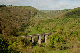
The Cromford and High Peak Railway (C&HPR) was a standard-gauge line between the Cromford Canal wharf at High Peak Junction and the Peak Forest Canal at Whaley Bridge. The railway, which was completed in 1831, was built to carry minerals and goods through the hilly rural terrain of the Peak District within Derbyshire, England. The route was marked by a number of roped worked inclines. Due to falling traffic, the entire railway was closed by 1967.

<span class="mw-page-title-main">High Peak Trail</span> Bridleway in the English Peak District

The High Peak Trail is a 17-mile (27 km) trail for walkers, cyclists and horse riders in the Peak District of England. Running from Dowlow (53.2059°N 1.8349°W), near Buxton, to High Peak Junction, Cromford (53.1004°N 1.5354°W), it follows the trackbed of the former Cromford and High Peak Railway, which was completed in 1831 to carry minerals and goods between the Cromford Canal wharf at High Peak Junction and the Peak Forest Canal at Whaley Bridge.

<span class="mw-page-title-main">Tissington Trail</span> Bridleway in the English Peak District

The Tissington Trail is a bridleway, footpath and cycleway in Derbyshire, England, along part of the trackbed of the former railway line connecting Ashbourne to Buxton. It takes its name from the village of Tissington, which it skirts. Opened in 1971, and now a part of the National Cycle Network, it stretches for 13 miles (21 km) from Parsley Hay (53.1706°N 1.7828°W) in the north to Ashbourne (53.0196°N 1.7397°W) in the south.

<span class="mw-page-title-main">Derwent Valley line</span> Matlock to Derby railway line

The Derwent Valley line is a railway line from Derby to Matlock in Derbyshire.

<span class="mw-page-title-main">Matlock railway station</span> Railway station in Derbyshire, England

Matlock railway station is owned by Network Rail and managed by East Midlands Railway; it serves the Derbyshire Dales county town of Matlock, Derbyshire, England. The station is the terminus of both the Derwent Valley Line from Derby and Peak Rail who operate heritage services to Rowsley South. Both lines are formed from portions of the Midland Railway's former main line to Manchester Central. Through running is technically possible but is not done in normal service.

<span class="mw-page-title-main">Manchester, Buxton, Matlock and Midland Junction Railway</span> Railway in England

The Manchester, Buxton, Matlock and Midland Junction Railway ran from a junction with the Midland Railway at Ambergate to Rowsley north of Matlock and thence to Buxton.

<span class="mw-page-title-main">Buxton railway station</span> Railway station in Derbyshire, England

Buxton railway station serves the Peak District town of Buxton in Derbyshire, England. It is managed and served by Northern Trains. The station is 25+34 miles (41.4 km) south east of Manchester Piccadilly and is the terminus of the Buxton line.

<span class="mw-page-title-main">Parsley Hay railway station</span> Former railway station in Derbyshire, England

Parsley Hay railway station served Parsley Hay, a hamlet within Hartington Middle Quarter civil parish, about 9.3 miles (15 km) south east of Buxton, Derbyshire, on the LNWR line to Ashbourne. The nearest large settlement is the village of Hartington.

The Monsal Trail is a cycling, horse riding and walking trail in the Derbyshire Peak District. It was constructed from a section of the former Manchester, Buxton, Matlock and Midland Junction Railway, which was built by the Midland Railway in 1863 to link Manchester with London and closed in 1968. The Monsal Trail is about 8.5 miles (13.7 km) long and opened in 1981. It starts at the Topley Pike junction in Wye Dale, 3 miles (4.8 km) east of Buxton, and runs to Coombs Viaduct, 1 mile (1.6 km) south-east of Bakewell. It follows the valley of the River Wye. The trail passes through Blackwell Mill, Chee Dale, Millers Dale, Cressbrook, Monsal Dale, Great Longstone, Hassop and Bakewell. The trail has numerous landmarks including Headstone Viaduct, Cressbrook Mill, Litton Mill and Hassop railway station, and passes through six tunnels.

The Ashbourne line was a 33+12 mi (53.9 km) railway from Buxton via Ashbourne to Uttoxeter. It was built by the London and North Western Railway using a section of the Cromford and High Peak Railway (C&HPR) and it joined the North Staffordshire Railway at Ashbourne, proceeding to Uttoxeter with a junction onto the main line at Rocester.

Thorpe Cloud railway station was opened in 1899 between the villages of Thorpe and Fenny Bentley in Derbyshire, south east of Buxton.

<span class="mw-page-title-main">Alsop en le Dale railway station</span> Former railway station in Derbyshire, England

Alsop en le Dale railway station was opened in 1899 near Alsop en le Dale and Alstonefield, villages in Derbyshire southeast of Buxton.

<span class="mw-page-title-main">Ashbourne railway station</span> Former railway station in Derbyshire, England

Ashbourne railway station formerly served the town of Ashbourne in Derbyshire. There have been two stations in the town. The first, opened in 1852, was operated by the North Staffordshire Railway (NSR); it was replaced in 1899 by a station at a new location, jointly operated by the NSR and the London and North Western Railway (LNWR). In 1923 the station passed into the ownership of the London, Midland and Scottish Railway and in 1948 that of the London Midland Region of British Railways. It was finally closed to all traffic in 1963.

<span class="mw-page-title-main">White Peak Loop Trail</span> Recreational trail in the English Peak District

The White Peak Loop is a 60-mile (97 km) route for walking, cycling and horse riding in the Peak District of England. The trail combines sections of the High Peak Trail and the Monsal Trail with linking sections through the towns of Buxton, Bakewell and Matlock. The White Peak Loop is being developed by Derbyshire County Council and as of 2022 some sections are not yet complete.

References

  1. "Neighbourhood Statistics". Office for National Statistics. Archived from the original on 23 October 2014. Retrieved 18 October 2014.
  2. "Ashbourne (Derbyshire, East Midlands, United Kingdom) – Population Statistics and Location in Maps and Charts". www.citypopulation.de. Archived from the original on 25 March 2015. Retrieved 21 September 2016.
  3. "City Population. Retrieved 6 January 2021". Archived from the original on 30 September 2020. Retrieved 6 January 2021.
  4. "Key to English Place-names". kepn.nottingham.ac.uk. Archived from the original on 29 June 2021. Retrieved 18 July 2021.
  5. "Ashbourne Town Guide – what to do and what to see in Ashbourne". www.derbyshireuk.net. Archived from the original on 28 October 2012. Retrieved 19 September 2012.
  6. Moat, Helen (2016). The Peak District. Bradt Travel Guides. p. 149. ISBN   978-1784770075.
  7. "A general ACCOUNT of the Conduct and Proceedings of the REBELS during their Stay at DERBY" . Derby Mercury. 29 November 1745. Archived from the original on 18 July 2021. Retrieved 26 December 2015 via findmypast.
  8. "Venues". Ashbourne Town Council. Retrieved 26 December 2021.
  9. OS Explorer map: 259: Derby (Map). Ordnance Survey.
  10. 1 2 3 "Sales decline shuts Ashbourne Water". Ashbourne News Telegraph. 3 May 2006. Archived from the original on 23 September 2015. Retrieved 29 June 2015.
  11. "Ashbourne and Matlock tourist information centres set to close". BBC News. 12 December 2011. Archived from the original on 25 October 2018. Retrieved 28 January 2018.
  12. "Tourist Information Office". Ashbourne Town Council. Archived from the original on 29 January 2018. Retrieved 28 January 2018.
  13. "Ashbourne Fairtrade Town Initiative". www.ashbournefairtrade.org.uk. Archived from the original on 3 March 2021. Retrieved 18 July 2021.
  14. "Aims of the Society". The Ashbourne Show. Archived from the original on 19 May 2015. Retrieved 18 May 2015.
  15. "Freeview Light on the Ashbourne (Derbyshire, England) transmitter". UK Free TV. Retrieved 19 September 2023.
  16. "Bauer buys Imagine to extend Greatest Hits Radio". RadioToday. 17 June 2021. Retrieved 19 September 2023.
  17. "Ashbourne News Telegraph". Reach Solutions. Retrieved 19 September 2023.
  18. "A sneak peek inside Ashbourne's new Green Man pub". Derby Telegraph. 27 July 2018. Archived from the original on 10 October 2019. Retrieved 10 October 2019.
  19. "Black man's head pub sign to go in racism row in Ashbourne". BBC News. 8 June 2020. Archived from the original on 8 June 2020. Retrieved 9 June 2020.
  20. "Ashbourne black man's head pub sign removed amid racism row". BBC News. 9 June 2020. Archived from the original on 1 July 2020. Retrieved 9 June 2020.
  21. Bland, Archie (9 June 2020). "Derbyshire town's 'racist' bust that faced removal hidden by residents". The Guardian . Archived from the original on 9 June 2020. Retrieved 9 June 2020.
  22. Bentley & Fox, J. M. & G. K. (1997). Railways of the High Peak Buxton to Ashbourne. Stockport UK: Foxline Publishing. p. 8. ISBN   1-870119-45-2.
  23. Kingscott, Geoffrey (2007). Lost Railways of Derbyshire. Newbury Berkshire UK: Countryside Books. p. 63. ISBN   978-1-84674-042-8.
  24. Derbyshire Dales District Council. The Limestone Way Walkers Guide. Matlock UK: Tourism Section DDDC. pp. 22–25.
  25. Ordnance Survey (2009). Explorer OL24. Southampton UK: Ordnance Survey. ISBN   978-0-319-24111-0. and Ordnance Survey (2008). Explorer 259. ISBN   978-0-319-23725-0.
  26. Long Distance Walkers Association. "Limestone Way". Archived from the original on 24 March 2013. Retrieved 7 March 2013.
  27. "The Patna Partnership". Ashbourne Churches Together. Archived from the original on 11 August 2013. Retrieved 7 March 2013.
  28. "World Championship". F1 Stockcars. Archived from the original on 16 November 2018. Retrieved 28 January 2018.
  29. David L. Wykes, "Cantrell, Henry, Church of England clergyman and religious controversialist" Oxford Dictionary of National Biography, Oxford University Press, 2004.
  30. Kathryn M. Burton, "Boothby, Hill (1708–1756)", Oxford Dictionary of National Biography, Oxford University Press, 2004 accessed 2 January 2017 Archived 18 July 2021 at the Wayback Machine .
  31. Rebecca Mills, "Boothby, Sir Brooke, seventh baronet (1744–1824)", Oxford Dictionary of National Biography, Oxford University Press, 2004; online edition, May 2010 accessed 2 January 2017 Archived 18 July 2021 at the Wayback Machine
  32. "Catherine Booth Biography". s9.com. Archived from the original on 28 May 2007. Retrieved 19 October 2016.