Ripley, Derbyshire

Last updated

Ripley
Town Hall, Ripley - geograph.org.uk - 1373324.jpg
All Saints Church, Ripley - geograph.org.uk - 3005952.jpg
Grosvenor Road Ripley - geograph.org.uk - 3013363.jpg
Ripley greenway geograph-2435421-by-Trevor-Rickard.jpg
Butterley (for Ripley ^ Swanwick) Station, Butterley, Ripley, Derbyshire - geograph.org.uk - 5575009.jpg
Clockwise from top: Ripley Town Hall, All Saints' Church, Grosvenor Road, Former railway line-turned greenway passing through the former railway station site and Midland Railway Heritage Railway
Derbyshire UK location map.svg
Red pog.svg
Ripley
Location within Derbyshire
Population20,176 (2021 Census) [1]
OS grid reference SK 39746 50502
District
Shire county
Region
Country England
Sovereign state United Kingdom
Areas of the town
List
Post town RIPLEY
Postcode district DE5
Dialling code 01773
Police Derbyshire
Fire Derbyshire
Ambulance East Midlands
UK Parliament
List of places
UK
England
Derbyshire
53°03′00″N1°24′25″W / 53.050°N 1.407°W / 53.050; -1.407
Arms of Ripley Town Council
Crest On a Wreath of the Colours out of a Mural Crown Sable Flames proper issuant therefrom a Unicorn's Head Argent armed and crined Or charged with three Spearheads erect one and two Gules.
Blazon Vert on a Chevron Or between in chief two Stags' Heads caboshed and in base a Fleur de Lys Argent a Chevronel Sable surmounted by a Tudor Rose barbed and seeded proper all within a Bordure also Argent thereon six Horseshoes also Sable.
Motto Ingenium Industria Alitur (Skill Is Fostered By Diligence)
Granted to the urban district council on 8 April 1954. [2]

Ripley is a market and industrial town as well as a civil parish in the Amber Valley district of the ceremonial county of Derbyshire, England. It is located to the north-northeast of Derby, northwest of Heanor, southwest of Alfreton and northeast of Belper. The town forms a continuous urban area with Heanor, Eastwood and Ilkeston as part of the wider Nottingham Urban Area.

Contents

History

Little information remains as to when Ripley was founded, but it appears in the 1086 Domesday Book, when it was held by a man called Levenot. In 1251 Henry III granted a charter for "one market one day a week, on Wednesday, at [the] manor of Ryppeleg: and one fair each year lasting three days, on the Vigil Day and Morrow of St Helen". Ripley Fair antedates Nottingham Goose Fair. The market day was later altered to Saturdays, with an extra market on Fridays. [3] Medieval Ripley was just a few stone cottages and farms around a village green, with a few dwellings further afield. Corn was ground at a mill owned by the Abbot of Darley. In 1291, Ripley had "two water-mills with fish ponds".[ citation needed ]

The Ripley area has been industrialised since the late 18th century. One of the earliest firms to take advantage of local mineral resources was the Butterley Company. It was formed in 1790 by Benjamin Outram and Francis Beresford. Jessop and Wright joined as partners in 1791. Benjamin Outram and Jessop were pioneering engineers best known for their input into the rail industry and their engineering of the Cromford Canal. Outram developed the L-shaped flange rail and Jessop engineered the cast iron fish belly rail. The Little Eaton Gangway project was one of the engineering feats they completed. The engineering part of the company closed and the site of the Butterley Company was demolished in 2010. The company was latterly in three parts, Butterley Engineering, Butterley Brick and Butterley Aggregates as separate companies. Over the last 200 years these have dealt with steelworks, coal mining, quarrying, railway, foundry and brickworks. One of the best-known examples of the company's work is the arched roof of St Pancras railway station in London, restored as an international terminal. Post-2000 Butterley achievements were the design and construction of the Falkirk Wheel, a canal boat-lift funded by the Millennium Commission and the Spinnaker Tower seen in Portsmouth Harbour as the focus of its regeneration.

Ripley was also a mining community, with collieries owned by the Butterley Company until the Coal Industry Nationalisation Act 1946. These included Ripley colliery (1863–1948), Britain colliery (1918–1946), Ormonde 1908–1970, [4] and other pits at Upper and Lower Hartshay, Whiteley, Waingroves, Bailey Brook, Exhibition, Loscoe, New Langley and Denby Hall.

Governance

Ripley Town Hall Ripley - Town Hall.jpg
Ripley Town Hall

What is now Ripley Town Hall on the north side of the Market Place was erected in 1880 as a market hall. The architect was George Eyre of Codnor. It occupied the site of a much older dwelling known as The White House. The Market Hall was originally open on the ground floor. In 1907, it was converted into a Town Hall by the Urban District Council. In the 1990s, the building was much extended to the west and remodelled by Amber Valley Borough Council to form its headquarters. In 2012, the Council proposed to sell off some of the buildings under a rationalisation scheme. [5]

Demography

According to the 2021 census, Ripley's population was recorded at 20,176. The ethnic makeup of the town was recorded at 98% White British out of 19,703 residents, followed by Mixed Race at 1% out of 231 residents and 1% Asian out of 135 residents. The other ethnic groups made up less than 1% of the local population. In terms of religious makeup, Ripley's residents were recorded to be mostly non-religious at 51% of the local population at 9,696 residents followed by 48% of the towns residents identifying as Christian out of 9.044 residents. Other religions practiced in Ripley include Other religion (121 residents), Islam (57 residents) and Buddhism (57 residents). The town has a high ratio of Women compared to Men at 51% (Women) and 49% (Male). [6]

Education

Primary schools

Secondary schools

Pre-schools

All Saints Church All Saints Church, Ripley 2394749 e87b367e.jpg
All Saints Church

Religion

The Methodist Church in Wood Street is reputed to be the oldest church in the town that is still active. At the peak of the movement there were five Methodist churches in Ripley, but the congregations combined over the years. [7] The church was rebuilt on the same site and reopened in November 2009. See History of Methodism in Ripley Derbyshire

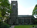
An outcome of the nearby Pentridge (or Pentrich) Rising of 1817 was for the Vicar of Pentrich Church to call for an Anglican church to be built in Ripley as soon as possible. All Saints' Church, Ripley was erected in 1821 by the Butterley Company.

Other places of worship include the Salvation Army hall in Heath Road, which was opened in 1911, the Springs of the Living Water housed in the former St John's Church in Derby Road, the Spiritual Church in Argyll Road, and Marehay Methodist Chapel in Warmwells Lane, Marehay.

Transport

Running under the premises of the Butterley Company is the 2,966-yard (2,712 m) Butterley Tunnel on the Cromford Canal. [8] The central section of the canal is disused, but a charitable fund has been formed to reopen it. [9]

Ripley is the site of Midland Railway – Butterley (formerly the Midland Railway Centre), a trust dedicated to preserving railway locomotives, rolling stock and other items related to the Midland Railway.

Ripley was once served by Ripley railway station on the Midland Railway Ripley Branch. It was the northern terminus of the Nottinghamshire and Derbyshire Tramways Company and later of the Nottinghamshire and Derbyshire trolleybus system.

Media

Local news and television programmes are provided by BBC East Midlands and ITV Central. Television signals are received from the Waltham TV transmitter. [10]

Ripley's local radio stations are BBC Radio Derby on 104.5 FM, Smooth East Midlands on 101.4 FM, Capital East Midlands on 102.8 FM, Greatest Hits Radio Midlands on 106 FM and Amber Sound FM, a community station which is based in the Unicorn Business Park off Wellington Street. The station broadcasts on 107.2FM in the Amber Valley and online.

Local newspapers are the Ripley & Heanor News and Derbyshire Times . [11]

Parks and natural features

Butterley Reservoir, at the bottom of Butterley Hill in the north of the town, has pairs of great crested grebe, coot, moorhens and other birds to watch, and platforms for anglers to use. There is a footpath that takes in the scenery, with the Midland Railway Trust in the background.

Wildlife and a small woodland area can be enjoyed at Carr Wood, signposted from halfway down Butterley Hill.

At the bottom of Moseley Street, next to the Red Lion pub in Ripley Town Centre, is a recreation area named after Sir Barnes Wallis, which offers views over to Crich Stand, the Sherwood Foresters Memorial. Crich Stand was built by Francis Hurt in 1778 and in 1922 dedicated to the fallen of the Sherwood Foresters Regiment (colloquially known as the Woofers) in World War I. It is now the memorial for those in the Regiment who died in all conflicts. [12]

The Pit Top is an open area with some seating and a white arch sculpture. The grassed area is the site of the original Ripley Colliery, owned by Butterley Company and worked from 1863 until 1948. [4]

Crossley Park is a few acres of grassed land opened in 1935. It is surrounded by shrubs and trees on a tract given to the town by James Crossley in 1901. It has a children's play area with a paddling pool, a paved perimeter walk, and a bandstand used as such occasionally on late Sunday afternoons in the summer.

Twin towns

Ripley is twinned with the French towns of Château-Renault and Lons-le-Saunier.

Community and facilities

The headquarters of Derbyshire Constabulary is on the outskirts of Ripley at Butterley Hall.

Ripley has a community hospital with a minor accident and emergency department that opened on 7 September 1912. The hospital was built after the death of a miner injured at Pentrich Colliery, who did not survive the road journey to Derby in time for treatment. [13] The Ripley Hospital League of Friends has been an active fund-raising group for the hospital throughout its history.

Ripley has a Scout group founded in 1914. For younger children it has two Beaver colonies and a Cub pack. [14]

The Ripley Music Festival has been held in the town since 2001.

Notable residents

See also

Related Research Articles

<span class="mw-page-title-main">Amber Valley</span> Non-metropolitan district and borough in England

Amber Valley is a local government district with borough status in the east of Derbyshire, England, taking its name from the River Amber. Its council is based in Ripley. The district covers a semi-rural area lying to the north of the city of Derby. The district contains four main towns whose economy was based on coal mining and remains to some extent influenced by engineering, distribution and manufacturing, holding for instance the headquarters and production site of Thorntons confectionery.

<span class="mw-page-title-main">Alfreton</span> Town and civil parish in Amber Valley, Derbyshire, England

Alfreton is a town and civil parish in the Amber Valley district of Derbyshire, England. The town was formerly a Norman Manor and later an Urban District. The population of the Alfreton parish was 8,799 at the 2021 Census. The villages of Ironville, Riddings, Somercotes and Swanwick were historically part of the Manor and Urban District, and the population including these was 24,476 in 2001.

<span class="mw-page-title-main">Heanor</span> Town in Derbyshire, England

Heanor (/ˈhiːnə/) is a town in the Amber Valley district of Derbyshire in the East Midlands of England. It lies 8 miles (13 km) north-east of Derby and forms, with the adjacent village of Loscoe, the civil parish and town council-administered area of Heanor and Loscoe, which had a population of 17,251 in the 2011 census.

<span class="mw-page-title-main">William Jessop</span> British civil engineer (1745-1814)

William Jessop was an English civil engineer, best known for his work on canals, harbours and early railways in the late 18th and early 19th centuries.

<span class="mw-page-title-main">Cromford Canal</span>

The Cromford Canal ran 14.5 miles from Cromford to the Erewash Canal in Derbyshire, England with a branch to Pinxton. Built by William Jessop with the assistance of Benjamin Outram, its alignment included four tunnels and 14 locks.

<span class="mw-page-title-main">Midland Railway – Butterley</span> British heritage railway centre

The Midland Railway – Butterley is a heritage railway and museum complex at Butterley, near Ripley in Derbyshire.

Benjamin Outram was an English civil engineer, surveyor and industrialist. He was a pioneer in the building of canals and tramways.

<span class="mw-page-title-main">Little Eaton Gangway</span> British narrow gauge industrial wagonway (1795-1908)

The Little Eaton Gangway, officially the Derby Canal Railway, was a narrow gauge industrial wagonway serving the Derby Canal, in England, at Little Eaton in Derbyshire.

<span class="mw-page-title-main">Codnor</span> Village and civil parish in Derbyshire, England

Codnor is a village and civil parish in the Amber Valley district of Derbyshire, England. Codnor is a former mining village and had a population of 3,766 taken at the 2011 Census. It is approximately 12 miles from Derby and 14 miles from Nottingham. Codnor forms a built up area with nearby Ripley.

<span class="mw-page-title-main">Heanor and Loscoe</span> Civil parish in Derbyshire, England

Heanor and Loscoe is a civil parish within the Amber Valley district, which is in the county of Derbyshire, England. Mainly built up with rural fringes, its population was 17,251 residents in the 2011 census. The parish is 120 miles (190 km) north west of London, 10 miles (16 km) north east of the county city of Derby, and contains the market town of Heanor along with other areas. It shares a boundary with the parishes of Aldercar and Langley Mill, Codnor, Denby, Shipley and Smalley.

The Erewash Valley Line is a railway line in England, running from Long Eaton, located between Nottingham and Derby, and Clay Cross, near Chesterfield. The southern part was opened by the Midland Railway in 1847 as far as Codnor Park, where it connected to established ironworks, and soon after, a line to Pinxton and Mansfield.

<span class="mw-page-title-main">Butterley Company</span> English manufactuering company

The Butterley Company was an English manufacturing firm founded as Benjamin Outram and Company in 1790. Its subsidiaries existed until 2009.

<span class="mw-page-title-main">Bullbridge</span> Human settlement in England

Bullbridge is a small village in Derbyshire. The Bull bridge accident, in which a railway bridge failed as a goods train was just passing over it, happened here in 1860.

<span class="mw-page-title-main">Butterley Tunnel</span>

Butterley Tunnel is a 3,083-yard (2,819 m) disused canal tunnel on the Cromford Canal below Ripley, in Derbyshire, England, opened to traffic in 1794. Along with Butterley Works blast furnaces, part of the canal tunnel and its underground wharf were declared a scheduled monument in 2013.

<span class="mw-page-title-main">Langley Mill railway station (Erewash Valley line)</span> Former railway station in Derbyshire, England

Langley Mill railway station was a railway station which served the village of Langley Mill in Derbyshire, England. It was opened in 1895 by the Midland Railway on its branch between Heanor Junction on the Erewash Valley Line and Ripley.

Crosshill and Codnor railway station was a railway station which served the villages of Crosshill and Codnor in Derbyshire, England It was opened in 1890 by the Midland Railway on its branch between Langley Mill on the Erewash Valley Line and Ripley

Heanor railway station was a railway station which served the town of Heanor in Derbyshire, England. It was opened in 1890 by the Midland Railway on its branch between Langley Mill (Branch) railway station on the Erewash Valley Line and Ripley

<span class="mw-page-title-main">Midland Railway Ripley Branch</span>

The Midland Railway Ripley Branch connected Derby to Ripley in Derbyshire, England running from Little Eaton Junction on the Midland Railway line to Leeds.

Ripley Hospital is a health facility in Sandham Lane, Ripley, Derbyshire, England. It is managed by Derbyshire Community Health Services NHS Foundation Trust.

Ripley is a civil parish in the Amber Valley district of Derbyshire, England. The parish contains 62 listed buildings that are recorded in the National Heritage List for England. Of these, five are listed at Grade II*, the middle of the three grades, and the others are at Grade II, the lowest grade. The parish contains the town of Ripley, smaller settlements including Ambergate, Bullbridge, Butterley, Fritchley, Heage, Nether Heage and Waingroves, and the surrounding countryside. The Cromford Canal, now partly closed, runs through the parish, and the listed buildings associated with it are bridges and an embankment. Also running through the parish is a railway that originated as the North Midland Railway with a later branch, the Manchester, Buxton, Matlock and Midland Junction Railway, and associated with these are bridges, viaducts, a goods shed, and the portals of a tunnel. Most of the other listed buildings are houses, cottages and associated structures, farmhouses and farm buildings. The other listed buildings include churches, a windmill, a pair of coke iron furnaces, factory buildings, public houses, mileposts, colliery buildings, a railway station and signal box at Butterley, and a war memorial.

References

  1. "Ripley (Derbyshire, East Midlands, United Kingdom) - Population Statistics, Charts, Map, Location, Weather and Web Information". citypopulation.de. Retrieved 24 January 2024.
  2. "Ripley Town Council (Derbyshire)". Robert Young. Retrieved 31 October 2019.
  3. Wood, Brian (2007). Ripley, Heage and Ambergate: People, places and events. Ripley Town Council.
  4. 1 2 Bell, David (2006). Memories of the Derbyshire Coalfields. Newbury, Berkshire: Countryside Books. ISBN   1846740037.
  5. Historic England. "Monument No. 1319727". Research records (formerly PastScape). Retrieved 26 April 2015.
    "Ripley Town Hall". Picture The Past. Retrieved 26 April 2015.
    Pevsner, Nikolaus (2002). The Buildings of England – Derbyshire. Yale University Press. p. 309. ISBN   0-300-09591-0.
    Wright's Directory of Melbourne and Ripley. C. N. Wright. 1878.
  6. "Ripley (Derbyshire, East Midlands, United Kingdom) - Population Statistics, Charts, Map, Location, Weather and Web Information". citypopulation.de. Retrieved 25 January 2024.
  7. "Welcome to Ripley Methodist church". Ripley Methodist Church. Retrieved 23 December 2021.
  8. Witter, Robin (7 October 2002). "Butterley Tunnel – The Illustrated Report". Friends of the Cromford Canal. Archived from the original on 10 March 2009. Retrieved 24 December 2021.
  9. The Charity Friends of the Cromford Canal. Retrieved 20 July 2023
  10. "Full Freeview on the Waltham (Leicestershire, England) transmitter". UK Free TV. 1 May 2004. Retrieved 6 October 2023.
  11. "Ripley & Heanor News". British Papers. 27 May 2014. Retrieved 6 October 2023.
  12. Jewell, Rod (1998). Memory Lane: Belper, Ambergate and Districts. Derby: Breedon Books Publishing Co. ISBN   185983132X.
  13. Buxton, David (1994). Pocket Images: Ripley and Codnor. Gloucestershire: Nonsuch Publishing Ltd. ASIN   B00SLVVHXE.
  14. "Home page". 1st Ripley Scouts. Retrieved 24 December 2021.
  15. Colpus, Eve. "Slack, Agnes Elizabeth (1858–1946)". Oxford Dictionary of National Biography (online ed.). Oxford University Press. doi:10.1093/ref:odnb/103418.(Subscription or UK public library membership required.)
  16. Stewart, Iain. "Grave Location for Holders of The Victoria Cross in The County of: Derbyshire". The Victoria Cross: Britain's Highest Award for Gallantry. Retrieved 24 December 2021.
  17. Vetch, R. H. "Outram, Sir James, first baronet (1803–1863)". Oxford Dictionary of National Biography (online ed.). Oxford University Press. doi:10.1093/ref:odnb/20962.(Subscription or UK public library membership required.)