Brimington

Last updated

Brimington
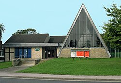
Brimington Methodist Church - photoshopped 239256.jpg
Methodist Church at Brimington
Derbyshire UK parish map highlighting Brimington.svg
Brimington parish highlighted within Derbyshire
Population8,788 (2011)
OS grid reference SK406736
Civil parish
  • Brimington
District
Shire county
Ceremonial county
Region
Country England
Sovereign state United Kingdom
Post town CHESTERFIELD
Postcode district S43
Dialling code 01246
Police Derbyshire
Fire Derbyshire
Ambulance East Midlands
UK Parliament
List of places
UK
England
Derbyshire

Brimington is a large village and civil parish in the Borough of Chesterfield in Derbyshire, England. The population of the parish taken at the 2011 census was 8,788. [1] The town of Staveley is to the east, and Hollingwood is nearby. The parish includes Brimington Common along the Calow Road, and New Brimington, a late 19th-century extension towards the Staveley Iron Works. [2]

Contents

History

The route of Icknield Street, a Roman road, passes close to the village. [3] Brimington appears in the Domesday Book of 1086 as Brimintune. At that time, the manor was the property of King William I and the population was recorded as being sixteen villagers, two smallholders and one slave. [4] Although there was a church in the village in the medieval period, it was a chapel of ease with the parish church being Chesterfield. [5] In the autumn of 1603, there was an outbreak of bubonic plague in Brimington; the victims were buried in the village but were recorded in the parish register at Chesterfield. [6] The Chesterfield Canal, which was built just to the north of the village, opened in 1777. [7] In 1796, the old church of St Michael and All Angels was demolished and replaced with a new building, of which only the tower survives. The present church was rebuilt in 1847 and contains a war memorial by Charles Sargeant Jagger; it is a Grade II listed building. [8] A Wesleyan Methodist chapel was built in 1806. [7] In 1831, the population of Brimington was 759 people living in 142 houses. [9] In 1881, Alfred Gough was hanged in Derby for the murder of six year-old Eleanor Wendle of Brimington, who was picking blackberries in the local fields. [10] The manor house, Brimington Hall, was built in the 16th and 17th centuries and was the home of the Foljambe, Heywood, Coke and Markham families; it was demolished in 1924 but a fragment of its parkland survives as a green space on either side of Hall Road, just south of the church. [11]

Local government

Brimington was originally a chapelry within the ancient parish of Chesterfield, but was created a separate parish in September 1844. [7] The Local Government Act 1894 established it as a civil parish with a parish council distinct from the church. It forms two wards, of Chesterfield Borough Council; Brimington North and Brimington South. [12] The parish council maintains a community centre in Heywood Street which is used by a number of local organisations. [13]

Education

Brimington has two infant schools, Henry Bradley Infant School and Brimington Manor. Pupils generally feed into Brimington Junior School. Local secondary schools include Springwell Community College and Netherthorpe School.

Local amenities

Brimington has a small library, various businesses including a chemist, car garages and showrooms, shops and a petrol station.

There is an old pub called the Ark Tavern, next to what is now a care home. The building housing the care home used to be called Sutton Lodge (formerly Sutton Villa) and dates from about 1780–90. Other pubs in the centre of Brimington are Brimming with Beer, The Red Lion, The Three Horseshoes, The Butchers Arms and the most recently built, The Corner House, which has now been demolished and is part of the caravan store. Towards the lower end of Brimington, overlooking the Chesterfield Canal, is The Mill and along Brimington Common are The Miner's Arms and The Brickmakers Arms (which has since closed and has been converted into a residential property).

Brimington also has several takeaway businesses with foods including Indian, Bangladeshi, Chinese, pizza, kebab and several traditional fish and chip shops.

The village has two churches, an education centre and a taxi rank.

Chesterfield's crematorium is in Brimington, on the road into Chesterfield. Built in 20 acres of ground bought in 1954, it was opened in 1959. [14] Sergeant Fred Greaves (1890–1973), a recipient of the Victoria Cross in the First World War, a resident of Brimington, was cremated here. [15]

Brimington's Memorial Gates commemorate the village soldiers of both World Wars and is situated on Manor Road. A website is dedicated to the men from the village who died in the First World War. [16]

See also

Related Research Articles

<span class="mw-page-title-main">Staveley, Derbyshire</span> Town in Derbyshire, England

Staveley is a town and civil parish in the Borough of Chesterfield, Derbyshire, England. Located along the banks of the River Rother. It is northeast of Chesterfield, west of Clowne, northwest of Bolsover, southwest of Worksop and southeast of Sheffield.

<span class="mw-page-title-main">Chesterfield, Derbyshire</span> Town in Derbyshire, England

Chesterfield is a market and industrial town in the ceremonial county of Derbyshire, England. It is 24 miles (39 km) north of Derby and 11 miles (18 km) south of Sheffield at the confluence of the Rivers Rother and Hipper. In 2011, the built-up-area subdivision had a population of 88,483, making it the second-largest settlement in Derbyshire, after Derby. The wider Borough of Chesterfield had a population of 103,569 in the 2021 Census. In 2021, the town itself had a population of 76,402.

<span class="mw-page-title-main">Hartshorne, Derbyshire</span> Village in Derbyshire, England

Hartshorne is a village and civil parish in the English county of Derbyshire. The population of the civil parish at the 2011 census was 3,888. It is north of the town of Swadlincote.

<span class="mw-page-title-main">Eckington, Derbyshire</span> Town in North East Derbyshire, England

Eckington is a town and civil parish in North East Derbyshire, England. It is 7 miles (11 km) northeast of Chesterfield and 9 miles (14 km) southeast of Sheffield, on the border with South Yorkshire. It lies on the B6052 and B6056 roads close to the A6135 for Sheffield and Junction 30 of the M1. It had a 2001 population of 11,152, increasing to 11,855 at the 2011 Census.

<span class="mw-page-title-main">Chesterfield (UK Parliament constituency)</span> Parliamentary constituency in the United Kingdom, 1885 onwards

Chesterfield is a constituency represented in the House of Commons of the UK Parliament since 2010 by Toby Perkins of the Labour Party.

<span class="mw-page-title-main">Ashover</span> Village and civil parish in England

Ashover is a village and civil parish in the English county of Derbyshire. It is in the North East Derbyshire district of the county. The population of the civil parish taken at the 2011 Census was 1,905, increasing to 1,959 for the 2021 census. It sits in a valley, not far from the town of Matlock and the Peak District national park.

<span class="mw-page-title-main">Brampton, Derbyshire</span> Human settlement in England

Brampton is a suburb in the west of Chesterfield, Derbyshire. Originally a village known as New Brampton and separate from the town, it became absorbed into it over time due to urban sprawl. It is centred on Chatsworth Road, the main arterial road (A619) that connects the town with the Peak District and Manchester.

<span class="mw-page-title-main">Pilsley, North East Derbyshire</span> Human settlement in England

Pilsley is a village and civil parish in the district of North East Derbyshire in the county of Derbyshire, England, near the town of Chesterfield. At the 2011 Census the population was 3,487.

<span class="mw-page-title-main">Newbold, Derbyshire</span> Human settlement in England

Newbold is a village north of Chesterfield, Derbyshire, England, which in 2001 had a population of just under 8,000.

<span class="mw-page-title-main">Staveley, North Yorkshire</span> Village and civil parish in North Yorkshire, England

Staveley is a village and civil parish in the Harrogate district of North Yorkshire, England. It is situated 4 miles (6.4 km) north of Knaresborough and near the A1(M) motorway. In the 2001 census, the village had a population of 444, which had risen to 450 by the time of the 2011 census. In 2015, North Yorkshire County Council estimated the population to have dropped to 440.

Old Whittington is a village in the Borough of Chesterfield in Derbyshire, England. Old Whittington is 2 miles (3.2 km) north of Chesterfield and 10 miles (16 km) south-east of Sheffield. The population of the Old Whittington ward at the 2011 Census was 4,181. The village lies on the River Rother.

<span class="mw-page-title-main">Scarcliffe</span> Village in Derbyshire, England

Scarcliffe is a village and civil parish in the Bolsover district of Derbyshire, England. It is sometimes called Scarcliffe with Palterton. The population of the parish at the 2001 UK Census was 5,211, increasing to 5,288 at the 2011 Census.

<span class="mw-page-title-main">Tapton, Derbyshire</span> Human settlement in England

Tapton is a suburb of Chesterfield, in the county of Derbyshire, England. It is located along the Brimington Road B6543, between Chesterfield town centre, and Brimington. It became a suburb of Chesterfield in the 1920s. The buildings along Brimington road, which runs through the centre of Tapton, are testament to this fact. Consisting of semi-detached houses in a style typical of the 20s and 30s.

<span class="mw-page-title-main">Hollingwood</span> Village in Derbyshire, England

Hollingwood is a small village approximately four miles north east of Chesterfield, Derbyshire, England.

The Hundreds of Derbyshire were the geographic divisions of the historic county of Derbyshire for administrative, military and judicial purposes. They were established in Derbyshire some time before the Norman conquest. In the Domesday Survey of 1086 AD the hundreds were called wapentakes. By 1273 the county was divided into 8 hundreds with some later combined, becoming 6 hundreds over the following centuries. The Local Government Act 1894 replaced hundreds with districts. Derbyshire is now divided into 8 administrative boroughs within the Derbyshire County Council area.

<span class="mw-page-title-main">Borough of Chesterfield</span> Borough and non-metropolitan local government district Derbyshire, England

The Borough of Chesterfield is a non-metropolitan district with borough status in Derbyshire, England. It is named after the town of Chesterfield, its largest settlement, and also contains the town of Staveley and the large village of Brimington. In 2022 it had a population of 104,110.

<span class="mw-page-title-main">Brampton, North East Derbyshire</span> Civil parish in Derbyshire, England

Brampton is a civil parish in North East Derbyshire, England, with a population of 1,201 in 2011. Lying 130 miles (210 km) north west of London, 20 miles (32 km) north of Derby, and 2 miles (3.2 km) west of the market town of Chesterfield, Brampton encompasses part of the Peak District national park to the west, and shares a border with the Borough of Chesterfield, Barlow, Baslow and Bubnell, Beeley, and Holymoorside and Walton. The parish contains a number of settlements including the village it was named after, but does not include the nearby built-up suburb of Brampton which is now within the Chesterfield unparished area.

<span class="mw-page-title-main">Holymoorside and Walton</span> Civil parish in Derbyshire, England

Holymoorside and Walton is a civil parish within the North East Derbyshire district, which is in the county of Derbyshire, England. Named for its main settlements, with a mix of a number of villages and hamlets amongst a large rural area, it had a population of 2,138 residents in 2021. The parish is 130 miles (210 km) north west of London, 20 miles (32 km) north of the county city of Derby, and 2 miles (3.2 km) south west of the nearest market town of Chesterfield. It is adjacent with the Peak District national park to the west, and shares a border with the district of Chesterfield, along with the parishes of Ashover, Beeley, Brampton as well as Wingerworth. The parish paradoxically does not include the majority of the nearby built-up suburb of Walton, Chesterfield which is now within an adjacent unparished area of the borough.

<span class="mw-page-title-main">Grassmoor, Hasland and Winsick</span> Civil parish in Derbyshire, England

Grassmoor, Hasland and Winsick is a civil parish within the North East Derbyshire district, which is in the county of Derbyshire, England. Named for local settlements, with a mix of a number of villages and hamlets amongst a semi-rural area, it had a population of 3,360 residents in 2011. The parish is 130 miles (210 km) north west of London, 20 miles (32 km) north of the county city of Derby, and 2 miles (3.2 km) south east of the nearest market town of Chesterfield. It shares a boundary with the borough of Chesterfield, along with the parishes of Calow, North Wingfield, Temple Normanton, Tupton as well as Wingerworth. The parish paradoxically does not include the majority of the nearby built-up suburb of Hasland which is now within an adjacent unparished area of Chesterfield.

References

  1. UK Census (2011). "Local Area Report – Brimington Parish (E04002712)". Nomis. Office for National Statistics . Retrieved 7 November 2021.
  2. "History | Brimington Parish Council" . Retrieved 25 September 2020.
  3. Hall, Rev. George (1839). The History of Chesterfield: With Particulars of the Hamlets Contiguous to the Town. London: Whittaker and Co. p. 342.
  4. Powell-Smith, Anna; Palmer, Professor J.J.N. "Brimington". opendomesday.org. Open Domesday. Retrieved 30 May 2020.
  5. Hall p. 341
  6. Hall pp. 341-342
  7. 1 2 3 "Brimington". www.genuki.org.uk. UK and Ireland Genealogy. Retrieved 30 May 2020.
  8. Historic England (6 June 2004). "PARISH CHURCH OF ST MICHAEL AND ALL ANGELS (1088303)". National Heritage List for England . Retrieved 30 May 2020.
  9. Hall p. 342
  10. "Alfred Gough". www.britishexecutions.co.uk. British Executions. Retrieved 30 May 2020.
  11. "Lost Houses of Derbyshire – Brimington Hall". www.countryimagesmagazine.co.uk. Images Publishing Ltd. 1 May 2019. Retrieved 30 May 2020.
  12. "Chesterfield council elections". BBC . Andrew Teale . Retrieved 30 May 2020.
  13. "Brimington Community Centre". www.communitydirectoryderbyshire.org.uk. Third Sector Support for Derbyshire. Retrieved 30 May 2020.
  14. "Crematorium - Chesterfield Borough Council". Archived from the original on 3 October 2013. Retrieved 4 August 2013. Chesterfield local council website.
  15. Burial locations VC holders.
  16. www.brimington-memorial.co.uk

53°15′29″N1°23′26″W / 53.2580°N 1.3905°W / 53.2580; -1.3905