
Glossop is a market town in the borough of High Peak, Derbyshire, England, 15 miles (24 km) east of Manchester, 24 miles (39 km) north-west of Sheffield and 32 miles (51 km) north of Matlock. Near Derbyshire's borders with Cheshire, Greater Manchester, South Yorkshire and West Yorkshire, between 150 and 300 metres above sea level, it is bounded by the Peak District National Park to the south, east and north. In 2021, it had a population of 33,340.

The Derwent is a river in Derbyshire, England. It is 50 miles (80 km) long and is a tributary of the River Trent, which it joins south of Derby. Throughout its course, the river mostly flows through the Peak District and its foothills.

The River Ashop is a river in the Derbyshire Peak District, England. Its source is on the eastern slopes of Mill Hill, three miles south east of Glossop and just north of Kinder Scout.

The A57 is a major road in England. It runs east from Liverpool to Lincoln via Warrington, Salford and Manchester, and then through the Pennines over the Snake Pass (between the high moorlands of Bleaklow and Kinder Scout), around the Ladybower Reservoir, through Sheffield and past Worksop. Between Liverpool and Glossop, the road has largely been superseded by the M62, M602 and M67 motorways. Within Manchester a short stretch becomes the Mancunian Way, designated A57(M).

Bamford is a village in the Peak District, Derbyshire, England, close to the River Derwent. To the north-east is Bamford Edge, and to the north-west the Ladybower, Derwent and Howden Reservoirs. At the 2011 census, it had a population of 1,241.

Hadfield is a town in the High Peak of Derbyshire, England, with a population at the 2021 Census of 6,763. It lies on the south side of the River Etherow, near to the border with Greater Manchester, at the western edge of the Peak District close to Glossop. It doubled as the fictional town of Royston Vasey in the BBC comedy series The League of Gentlemen.

Greenfield is a village in the civil parish of Saddleworth in the Metropolitan Borough of Oldham, in Greater Manchester, England. It is 4 miles (6.4 km) east of Oldham and 13 miles (21 km) north-east of Manchester. It is located in a broad rural area at the southern edge of the South Pennines; Dovestone Reservoir, Chew Reservoir and Greenfield Reservoir lie to the east of the village in the Peak District National Park.

Hulleys of Baslow is a bus company based in Baslow, Derbyshire, England.

Stockport railway station serves the large market and industrial town of Stockport in Greater Manchester, England. It is located 6 miles south-east of Manchester Piccadilly, on a spur of the West Coast Main Line to London Euston.

Snake Pass is a hill pass in the Derbyshire section of the Peak District, crossing the Pennines between Glossop and the Ladybower Reservoir at Ashopton. The road was engineered by Thomas Telford and opened in 1821. The pass carries the A57 road between Manchester and Sheffield, but it is no longer the main signposted route between those two cities, with traffic instead directed through the Woodhead Pass to the north.

Guide Bridge railway station serves Guide Bridge in Audenshaw, Greater Manchester, England, and is operated by Northern Trains. The station is 4+3⁄4 miles (7.6 km) east of Manchester Piccadilly on both the Rose Hill Marple and Glossop Lines.

Transport in Sheffield, England is developed around the city's unusual topography and medieval street plan. Once an isolated town, the transport infrastructure changed dramatically in the 19th and 20th centuries. The city now has road and rail links with the rest of the country, and road, bus and trams for local transport.

London Buses route 18 is a Transport for London contracted bus route in London, England. Running between Sudbury & Harrow Road station and Euston bus station, it is operated by RATP Dev Transit London.

Newton for Hyde railway station, serves the Newton area of Hyde in Greater Manchester, England. Newton for Hyde is 7+1⁄2 miles (12.1 km) east of Manchester Piccadilly station and managed by Northern Trains. The station unusually features both a covered subway underneath the platforms and a larger viaduct tunnel accessible from both sides, meaning there are 2 ways to cross platforms underground. The eastern side of the station containing these passageways is raised on the viaduct.

The River Alport flows for 5.6 miles (9 km) in the Dark Peak of the Peak District in Derbyshire, England. Its source is on Bleaklow, 3 miles (4.8 km) east of Glossop, from which it flows south through the Grains in the Water bog, then over gritstone below the Alport Castles landslide to Alport Bridge on the A57 Snake Pass route from Sheffield to Manchester, where it joins the River Ashop. The Ashop flows into Ladybower Reservoir about 2.5 miles (4.0 km) down the valley, which discharges via the Rivers Derwent and Trent to the North Sea. The source of the Alport is close to the Pennine watershed.

Ashopton was a small village in Derbyshire, England, in the valley of the River Ashop. The village population was less than 100. Details are included in the civil parish of Aston, Derbyshire. In the early 1940s, the village was demolished to make way for the filling of Ladybower Reservoir.

Padfield is a small village near Hadfield in High Peak, Derbyshire, England. The village is on the west side of the Peak District National Park, and the nearest town is Glossop, where many local amenities and services are based. It is in a conservation area. The population as of the 2011 census was 2,796.
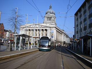
Nottingham is the seventh largest conurbation in the United Kingdom; despite this, the city's transport system was deemed to be poor for its size in the 1980s. In the early twenty-first century, the UK government invested heavily in the transport network of Nottingham, which has led to the re-opening of the Robin Hood Line and the construction of a light rail system, Nottingham Express Transit.

Tyne and Wear is a metropolitan area covering the cities of Newcastle upon Tyne and Sunderland, as well as North and South Tyneside, Gateshead and Washington.

The Wilmslow Road bus corridor is a 5.5-mile-long section of road in Manchester that is served by a large number of bus services. The corridor runs from Parrs Wood to Manchester city centre along Wilmslow and Oxford Roads, serving Didsbury, Withington, Fallowfield and Rusholme.

