The A1, also known as the Great North Road, is the longest numbered road in the United Kingdom, at 410 miles (660 km). It connects London, the capital of England, with Edinburgh, the capital of Scotland. It passes through or near north London, Hatfield, Welwyn Garden City, Stevenage, Baldock, Letchworth Garden City, Biggleswade, Eaton Socon, Buckden, Peterborough, Stamford, Grantham, Newark-on-Trent, Retford, Doncaster, Pontefract, York, Wetherby, Ripon, Darlington, Durham, Gateshead, Newcastle upon Tyne, Morpeth, Alnwick and Berwick-upon-Tweed.
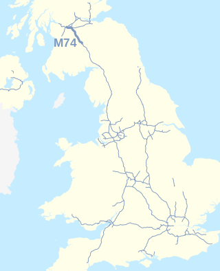
The A74(M) and M74 form a major motorway in Scotland, connecting it to England. The routes connect the M8 motorway in central Glasgow to the Scottish-English border at Gretna. In conjunction with their southward continuation, the M6 motorway, they form one of the three major cross-border routes between Scotland and England. They are part of the unsigned international E-road network E05. Although the entire route is colloquially referred to as the M74, for more than half its length, south of Abington, the road is officially the A74(M); see naming confusion below.

The A68 is a major road in the United Kingdom, running from Darlington in England to the A720 in Edinburgh, the capital of Scotland. It crosses the Anglo-Scottish border at Carter Bar and is the only road to do so for some distance either way; the next major crossings are the A697 from Coldstream to Cornhill-on-Tweed in the east, and the A7 near Canonbie to the west.

The A69 is a major northern trunk road in England, running east–west across the Pennines, through the counties of Tyne and Wear, Northumberland and Cumbria. Originally, the road started in the centre of Newcastle upon Tyne then later near Birtley, but since the creation of the A1 Western Bypass around Newcastle upon Tyne, it now starts at Denton Burn, a suburb of Newcastle upon Tyne.
The A167 and A167(M) is a road in North East England. It is partially a trunk road and partially a motorway, where it is commonly referred to as Newcastle Central Motorway. Most of the road’s route was formerly that of the A1, until it was re-routed with the opening of the A1(M) in the 1960s.

The A429 is a main road in England that runs in a north-northeasterly direction from junction 17 of the M4 motorway to Coventry in the West Midlands.

The Battle of Otterburn took place according to Scottish sources on 5 August 1388, or 19 August according to English sources, as part of the continuing border skirmishes between the Scots and English.

Hadrian's Wall Path is a long-distance footpath in the north of England, which became the 15th National Trail in 2003. It runs for 84 miles (135 km), from Wallsend on the east coast of England to Bowness-on-Solway on the west coast. For most of its length it is close to the remains of Hadrian's Wall, the defensive wall built by the Romans on the northern border of their empire. This is now recognised as part of the "Frontiers of the Roman Empire" World Heritage Site.

The A525 is a major route from Rhyl in Wales to Newcastle-under-Lyme in England. The route passes near Denbigh, through Ruthin, through Wrexham and near Whitchurch.

The A1068 is a road in northern England that runs from Seaton Burn in North Tyneside to Alnwick in Northumberland. The section between Ellington and Alnmouth is signposted as part of the Northumberland Coastal Route.

The A26 is a road in Northern Ireland. It travels in a north–south direction from Coleraine, County Londonderry to Banbridge, County Down.
There are 22 disused railway stations on the Bristol to Exeter line between Bristol Temple Meads and Exeter St Davids. The line was completed in 1844 at which time the temporary terminus at Beambridge was closed. The most recent closure was Tiverton Junction which was replaced by a new station} on a different site in 1986. 12 of the disused stations have structures that can still be seen from passing trains.

The A433 road is an A road and primary route in Gloucestershire, England.

Tyne and Wear is a metropolitan area covering the cities of Newcastle upon Tyne and Sunderland, as well as North and South Tyneside, Gateshead and Washington.
Otterburn Tower is a Grade II listed castellated, three star country house hotel in Otterburn, Northumberland. It is set in 32 acres (13 ha) of deer park and woodland in the Northumberland National Park in northeastern England. Founded by a cousin of William the Conqueror in 1086, it was later owned by the Clan Hall, before being rebuilt in 1830 by Thomas James, a magistrate, on the site and using some of the stones from the Otterburn Castle. Nearby Otterburn Hall was built in 1870 on land given to a Lord Douglas as recompense for the death of his ancestor James Douglas, 2nd Earl of Douglas in the Battle of Otterburn.

Otterburn Hall is an English country house and estate in Otterburn, Northumberland. It is situated in 500 acres (200 ha) of deer park and woodland in the Northumberland National Park, northeastern England. The building was constructed in 1870 for Lord James Douglas, the land given to him as recompense for the death of Lord James Douglas, who fought at the Battle of Otterburn, and was killed near Otterburn Tower, itself founded in 1086, and rebuilt in 1830. Both Otterburn Hall and Otterburn Castle have been seats of landed gentry.

St John the Evangelist's Church is a church in Otterburn, Northumberland, northeast England, located off the A696 road.

Otterburn Mill is a former textile mill in Otterburn, Northumberland, northeast England. It lies just south of the Otterburn Tower along the A696 road next to a bridge over the River Rede. It was owned by the Waddell family for many years and is over 250 years old. The mill is noted for its pram rugs and its crowning moment was on the birth of Princess Elizabeth in 1926, when Buckingham Palace contacted the mill requesting a rug for the royal pram. Otterburn Mill is now a shop selling outdoor, country and lifestyle clothing for men, women and children. Rena's Country Kitchen is an onsite café. Much of the historic machinery can still be seen and the history of the Waddell family is showcased across the site.
Ponteland Castle is a 13th-century stone tower house just off the A696 road in Ponteland, 8 miles north-west of Newcastle upon Tyne, in Northumberland. Founded by William de Valence, part of it was destroyed in a Scottish raid in 1388. In the 17th century it became part of a Jacobean manor house. The building is now occupied by the Blackbird Inn, and is rumoured to contain an old tunnel connecting it to St Mary's church across the road. The tunnel was supposedly bricked up behind the fireplace in The Tunnel Room.

Newcastle Great Park is a new suburb in the north of Newcastle upon Tyne, England. Much of Newcastle Great Park is still under development and is sandwiched in between older areas of Newcastle, namely Gosforth, Fawdon and Kingston Park to the south, and Hazlerigg to the north. Newcastle Great Park is the largest housing development in the North East of England.