Hitchin is a market town and unparished area in the North Hertfordshire district in Hertfordshire, England, with an estimated population of 33,350.

Baldock is a historic market town and unparished area in the local government district of North Hertfordshire in the county of Hertfordshire, England, where the River Ivel rises. It lies 33 miles (53 km) north of London, 15 miles (24 km) southeast of Bedford, and 14 miles (23 km) north northwest of the county town of Hertford. Nearby towns include Royston to the northeast, Letchworth and Hitchin to the southwest and Stevenage to the south.

East Barnet is an area of north London within the London Borough of Barnet bordered by New Barnet, Cockfosters and Southgate. It is a largely residential suburb whose central area contains shops, public houses, restaurants and services, and the parish church of St Mary the Virgin. East Barnet is close to the M25 and the A1 and M1.

St Ippolyts is a village and civil parish on the southern edge of Hitchin in Hertfordshire, England. It has a population of approximately 2,000.

Holwell is a small village and a civil parish two miles north of Hitchin in Hertfordshire, England, near the Bedfordshire border. The parish was historically part of Bedfordshire, being transferred to Hertfordshire on 30 September 1897. At the 2011 Census the population of the village was 361.
Lilley is a small village and civil parish situated between Hitchin and Luton in Hertfordshire, England. Lilley stands on high ground: nearby Telegraph Hill is just over 600 feet above sea level.

Graveley is a village and civil parish about four miles east of Hitchin and two miles north of Stevenage in Hertfordshire, England. The population of the parish in the 2011 census was 487. A milestone in the village states that it is 33 miles from London.

Great Wymondley is a village and former civil parish situated near Hitchin, now in the parish of Wymondley, in the North Hertfordshire district, in the county of Hertfordshire, England. Despite the names, Great Wymondley is a smaller settlement than its neighbour, Little Wymondley. In 1931 the parish had a population of 285.

Bendish is a hamlet located in the parish of St Paul's Walden in Hertfordshire. In the 18th century, Bendish was a small town. It is about 3 miles east of Luton, 5 miles south of Hitchin and 4.5 miles north of Harpenden. Many services such as the grocers, the 3 pubs and the Church have all closed.
Shephall is part of the town of Stevenage in Hertfordshire. It was formerly a separate village and parish, being absorbed into Stevenage in 1953.
Watton-at-Stone is a village in the English county of Hertfordshire, situated midway between the towns of Stevenage and Hertford in the valley of the River Beane. The 2011 census showed a population of 2,272 living in 946 households. Watton-at-Stone is also a civil parish in East Hertfordshire District Council.

Digswell is an ancient village and former parish in the English county of Hertfordshire which is recorded in the 1086 Domesday Book. The population of the urban area of Digswell in the 2011 Census was 1,632.
King's Walden is a civil parish in the English county of Hertfordshire. The name includes an apostrophe, but this is often omitted.
Little Amwell was a village and civil parish in Hertfordshire, England, lying 1.6 miles (2.6 km) south-east of the county town of Hertford. The old village of Little Amwell forms the northern part of the modern village of Hertford Heath. The civil parish of Little Amwell was abolished in 1990, merging with parts of the neighbouring parishes of Great Amwell, Stanstead St Margarets, and Ware to form the new parish of Hertford Heath. Little Amwell remains the name of the ecclesiastical parish which covers Hertford Heath. In 1961 the parish had a population of 982.
Hertingfordbury is a small village in Hertfordshire, England, close to the county town of Hertford. It was mentioned in the Domesday Book. Hertingfordbury is also the name of a neighbouring civil parish, which does not contain the village. Hertingfordbury Village is located within the Castle ward of local government Hertford Town Council. The population of the civil parish as of the 2011 census was 630.

Wymondley is a civil parish in Hertfordshire, England.

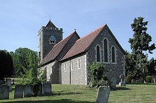
St Mary's Church is a Church of England parish church in Hitchin, Hertfordshire, England.
Eastwick is a village and civil parish 7 miles (11 km) east of Hertford, in the East Hertfordshire district, in the county of Hertfordshire, England. In 2011 the parish had a population of 194. The parish touches Gilston, High Wych, Hunsdon and Widford. Eastwick shares a parish council with Gilston.

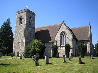
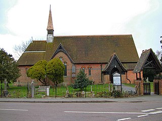
St Mary's Church is an active Anglican church in Great Wymondley, Hertfordshire, England. It is a Grade I listed building.