A1175 road

Last updated • 5 min readFrom Wikipedia, The Free Encyclopedia

52°41′53″N0°17′06″W / 52.698°N 0.285°W / 52.698; -0.285

Contents

UK road A1175.svg
A1175
Main Road, Uffington (A1175) - geograph.org.uk - 3176926.jpg
Main Road, Uffington (A1175)
Route information
Length17.8 mi (28.6 km)
Major junctions
East end Stamford, Lincolnshire
Major intersectionsUK road A43.svg A43
UK road A6121.svg A6121
UK road A15.svg A15
UK road A16.svg A16
West end Spalding, Lincolnshire
Location
Country United Kingdom
Constituent country England
Road network
UK road A1174.svg A1174 UK road A1176.svg A1176

The A1175 road is a road in south-west Lincolnshire, England. It runs between Stamford and Spalding, along the old A16 route.

History

It was previously designated as the southern section of the A16, but is now classified as the A1175 in following the completion of the new Peterborough to Spalding A16 section. The renaming also included a short section of A43 from the Stamford Bypass (A1) into Stamford. [1] [2]

At one time the section from Stamford to Market Deeping was designated part of the A43. [3] The new designation does not regard the route as a trunk.

Route

Stamford

The A1175 starts as a single carriageway at the A43 junction with the A1 Stamford Bypass, and follows Kettering Road into Stamford to the Junction in St Martins. It turns North as High St. St. Martins, passes over the town bridge (and the River Welland) and turns east along Wharf Road, Ryhall road, and Uffington Road. As Uffington road it crosses the River Gwash, Ben leaving Stamford at Newstead Mill.

Stamford to the Deepings

Still a single carriageway the A1175 passes through the villages of Uffington and Tallington. At Tallington level crossing, it is crossed on the level by the main London-Edinburgh railway line. The frequency of the trains often causes long delays here. [4] [5] After many years, there are at last plans for a solution. [6] Continuing in a roughly easterly direction the road passes Tallington lakes. The road formed the southern limit of the gravel workings from which the lakes were developed. The road skirts the northern edge of West Deeping where it is crossed by King Street (Roman road).

Deeping Bypass

The route turns left onto the dual carriageway Deeping Bypass, sharing the road with the A15 Peterborough to Bourne highway, as far as the roundabout for Bourne Road to the north of Market Deeping. From here the A15 departs northwards, and the A1175 heads east, reverting to single carriageway, having the bypass to itself. It crosses the Roman Car Dyke, two examples of civil engineering built nearly two millennia apart. [7]

The dual carriageway ends having bypassed Market Deeping and Deeping St James.

Before the Deeping Bypass was built this road went through Market Deeping and Deeping St James. This route is now known as the B1525. [2] The Deeping Bypass was opened in July 1998, and the whole works, A15 and former A16, cost £10 million. [8] [9] [10]

Deeping Fen

The whole extraparochial area to the west of Deeping St James was known as Littleworth, and hence the road as Littleworth Drove. But after successful drainage of Deeping Fen in the 18th and 19th century, the village of Deeping St Nicholas was created, and that portion of the road became High Street, Deeping St Nicholas, before reverting to the Littleworth name again at the other end of the village.

The A1175 then, whatever it might be called, leaves the Deeping bypass, still as single carriageway, and passes through the villages of Hop Pole, and Deeping St Nicholas, before crossing the Peterborough-Spalding railway line on an oblique level crossing at the former Littleworth railway station. The route the continues roughly North East past isolated farmhouses until the end of Deeping fen at the North Drove Drain.

Cowbit Wash

Cowbit is a village a short distance away on the former A1073 Spalding-Peterborough road. Cowbit wash is a low-lying area around the Welland designed to be flooded to protect Spalding. The road crosses this area at its Northern extent.

There is a bridge at over the minor North Drove Drain, the road skirts south of the hamlet of Bridge House (named for a defunct public house on the road) and crosses another bridge at over the main course of the River Welland. Within a short distance there is another bridge over the New River (an artificial course of the Welland) at where there is also a small roundabout.

The small Roundabout marks the crossing with the former A1073 Spalding-Peterborough road, since replaced by the new road which has taken the A16 designation. The former route is truncated to the north, but is still extant to the south as a minor road.

The A1175 continues north-east for around 200m more to its end at the Roundabout at, where the A16 Spalding Bypass and A16 Spalding-Peterborough meet the B1173 local road into Spalding.

Terrain

From Stamford to Uffington the route lies across the gently rolling hills of Upper Lincolnshire limestone, save where the Gwash has cut a valley down the Lower Lincolnshire Limestone. After Uffington, through Tallington to the end of the Deeping bypass at Littleworth, the terrain is flatter, described as river terrace sands and gravels overlying the mudstones of the Kellaway and Oxford clay formations. From Hop Pole onwards, Deeping Fen is formed of tidal zone deposits less than 2 million years old, over the same Oxford clays. This is the true fen, once brackish marsh until drained between the 16th and 19th centuries. [11] At Stamford the road is close to the 50m contour, falling to 22m at Uffington, 11m at West Deeping, and with spotheights of 2m or 3m across Deeping fen to the A16, rising only to cross the Welland Bridge. [12] [13]

The route roughly follows the route of the River Welland from Stamford to Spalding, and actually crosses it near either end, in Stamford and on the Cowbit Washes. [12] [13]

See also

Related Research Articles

<span class="mw-page-title-main">River Welland</span> Lowland river in the east of England

The River Welland is a lowland river in the east of England, some 65 miles (105 km) long. It drains part of the Midlands eastwards to The Wash. The river rises in the Hothorpe Hills, at Sibbertoft in Northamptonshire, then flows generally northeast to Market Harborough, Stamford and Spalding, to reach The Wash near Fosdyke. It is a major waterway across the part of the Fens called South Holland, and is one of the Fenland rivers that were laid out with washlands. There are two channels between widely spaced embankments with the intention that flood waters would have space in which to spread while the tide in the estuary prevented free egress. However, after the floods of 1947, new works such as the Coronation Channel were constructed to control flooding in Spalding, and the washlands are no longer used solely as pasture, but may be used for arable farming.

<span class="mw-page-title-main">A47 road</span> Road in England

The A47 is a major trunk road in England linking Birmingham to Lowestoft, Suffolk, maintained and operated by National Highways. Most of the section between Birmingham and Nuneaton is now classified as the B4114. From Peterborough eastwards, it is a trunk road.

<span class="mw-page-title-main">Stamford, Lincolnshire</span> Town in Lincolnshire, England

Stamford is a town and civil parish in the South Kesteven district of Lincolnshire, England. The population at the 2011 census was 19,701 and estimated at 20,645 in 2019. The town has 17th- and 18th-century stone buildings, older timber-framed buildings and five medieval parish churches. It is a frequent film location. In 2013 it was rated a top place to live in a survey by The Sunday Times. Its name has been passed on to Stamford, Connecticut, founded in 1641.

<span class="mw-page-title-main">South Kesteven</span> Local government district in Lincolnshire, England

South Kesteven is a local government district in Lincolnshire, England, forming part of the traditional Kesteven division of the county. Its council is based in Grantham. The district also includes the towns of Bourne, Market Deeping and Stamford, along with numerous villages and surrounding rural areas.

<span class="mw-page-title-main">A15 road (England)</span> Road in England

The A15 is a major road in England. It runs north from Peterborough via Market Deeping, Bourne, Sleaford and Lincoln along a variety of ancient, Roman, and Turnpike alignments before it is interrupted at its junction with the M180 near Scawby. The road restarts 10 miles (16 km) east, and then continues north past Barton-upon-Humber, crossing the Humber on the Humber Bridge before terminating at Hessle near Kingston upon Hull.

<span class="mw-page-title-main">A52 road</span> Major road in the East Midlands of England

The A52 is a major road in the East Midlands, England. It runs east from a junction with the A53 at Newcastle-under-Lyme near Stoke-on-Trent via Ashbourne, Derby, Stapleford, Nottingham, West Bridgford, Bingham, Grantham, Boston and Skegness to the east Lincolnshire coast at Mablethorpe. It is approximately 147 miles (237 km) long.

<span class="mw-page-title-main">Market Deeping</span> Town in Lincolnshire, England

Market Deeping is a market town and civil parish in the South Kesteven district of Lincolnshire, England, on the north bank of the River Welland and the A15 road. The population of the town at the 2011 census was 6,008.

<span class="mw-page-title-main">Uffington, Lincolnshire</span> Village and civil parish in Lincolnshire, England

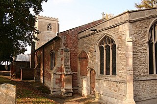
Uffington is a village and civil parish in the South Kesteven district of Lincolnshire, England. The population of the civil parish at the 2011 census was 686. It is in the valley of the River Welland, between Stamford and The Deepings.

Lincolnshire is a large county in England with a sparse population distribution, which leads to problems funding all sorts of transport. The transport history is long and varied, with much of the road network still based on the Roman model, and the once extensive rail network a shadow of its former self.

<span class="mw-page-title-main">A43 road</span> Road in England

The A43 is a primary route in the English Midlands and northern South East England, that runs from the M40 motorway near Ardley in Oxfordshire to Stamford in Lincolnshire. Through Northamptonshire it bypasses the towns of Northampton, Kettering and Corby which are the three principal destinations on the A43 route. The A43 also links to the M1 motorway.

<span class="mw-page-title-main">A16 road (England)</span> Road in Lincolnshire, England

The A16 road is a principal road of Lincolnshire in the East Midlands region of England, connecting the port of Grimsby and Peterborough, where it meets the A1175, A47 & A1139 then on to the A1 and the A605; the latter, in turn, giving a through route to Northampton and the west, and south west of England. Its length is 78 miles (126 km). The road was "de-trunked", with responsibility largely returned to Lincolnshire County Council from the Highways Agency in 2002.

<span class="mw-page-title-main">A17 road (England)</span> Road in England

The A17 road is a mostly single carriageway road linking Newark-on-Trent in Nottinghamshire, England, to King's Lynn in Norfolk. It stretches for a distance of 62 miles travelling across the flat fen landscapes of southern Lincolnshire and western Norfolk and links the East Midlands with East Anglia. The road is notable for its numerous roundabouts and notoriously dangerous staggered junctions and also for its most famous landmark, the Cross Keys Bridge at Sutton Bridge close to the Lincolnshire/Cambridgeshire/Norfolk borders which carries the road over the River Nene.

<span class="mw-page-title-main">Stamford Canal</span> Canal in Lincolnshire, England

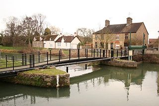
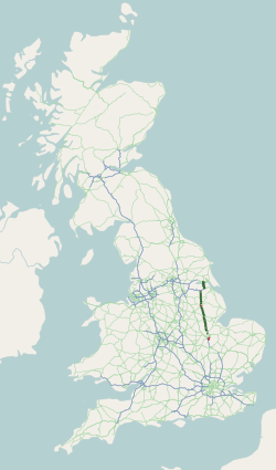
Stamford Canal, now disused, is one of the earliest post-Roman canals in England. It opened in 1670, around 100 years before the start of the Industrial Revolution which brought about the "golden age" for canals in Britain. Parts of the route can be traced on the ground, though only one lock survives intact. It was part of the Welland Navigation in Lincolnshire. First authorised in 1571, during the reign of Elizabeth I, construction did not start until 1664, under powers granted in 1620 and ratified by James I. It ran for 9.5 miles (15.3 km) from Stamford to Market Deeping and had 12 locks, two of which were on the river section at Deeping St James. No plans of its construction survive, although one of the locks was documented by a visiting water engineer in 1699. It contributed to the wealth of Stamford, allowing barley to be transported to the town for malting.

<span class="mw-page-title-main">Tallington</span> Village and civil parish in the South Kesteven district of Lincolnshire, England

Tallington is a village and civil parish in the South Kesteven district of Lincolnshire, England. The population of the civil parish at the 2011 census was 497. It is situated 4 miles (6 km) east from Stamford and 8 miles (13 km) north-west from the centre of Peterborough. The village has around 200 houses.

<span class="mw-page-title-main">A158 road</span> Road in England

The A158 road is a major route that heads from Lincoln in the west to Skegness on the east coast. The road is located entirely in the county of Lincolnshire and is single carriageway for almost its entirety. The road is approximately 40 miles (64 km) long. The road gets quite congested with holiday traffic during the summer.

<span class="mw-page-title-main">Cowbit</span> Village and civil parish in Lincolnshire, England

Cowbit is a village and civil parish in the South Holland district of Lincolnshire, England. The population of the civil parish at the 2011 census was 1,220. It is situated 3 miles (5 km) south from Spalding and 5 miles (8 km) north from Crowland.

<span class="mw-page-title-main">A631 road</span> Road in England

The A631 is a road running from Sheffield, South Yorkshire to Louth, Lincolnshire in England. It passes through the counties of South Yorkshire, Nottinghamshire and Lincolnshire. The road has many towns on its route including Rotherham, Maltby, Gainsborough and Market Rasen. It is mostly single road throughout its length but has some stretches of dual carriageway as well.

<span class="mw-page-title-main">A6121 road</span> Road in England

The A6121 is a short cross-country road in the counties of Lincolnshire and Rutland, England. It forms the principal route between Bourne and Stamford and the A1 in Lincolnshire, continuing on through Ketton in Rutland to its junction with the A47 at Morcott. Its south-western end is at 52°35.5860′N0°38.0820′W and its north-eastern end is at 52°45.9120′N0°24.0660′W. The road has increased in importance with the rapid expansion of housing in this part of South Kesteven.

<span class="mw-page-title-main">Peak Hill, Lincolnshire</span> Hamlet in the South Holland district of Lincolnshire, England

Peak Hill is a hamlet in the South Holland district of Lincolnshire, England. It is situated 4 miles (6 km) south from Spalding and 10 miles (16 km) north-east from Peterborough. The nearest village is Cowbit, about 1 mile (1.6 km) to the north.

<span class="mw-page-title-main">Lincolnshire loop line</span> Former railway line in England

The Lincolnshire loop line was a railway built by the Great Northern Railway, that linked Peterborough to Gainsborough via Spalding, Boston and Lincoln. It ran through the counties of Lincolnshire and Northamptonshire

References

  1. "A1073 Spalding to Eye Improvement Reclassification to A16". Highway improvement Completed projects A1073 – Spalding to Eye Improvement A1073 Reclassification Proposals. Lincolnshire county council. 2012. Retrieved 4 August 2013.
  2. 1 2 "Transport assessment Market Deeping" (PDF). pp. 5, 11. Retrieved 5 August 2013.[ permanent dead link ]
  3. E.G. "The A43 Oxford–Market Deeping Trunk Road (Kettering Northern Bypass) Order 1987". Statutory Instruments 1987 No. 1694. Hansard. 21 September 1987. Retrieved 5 August 2013. (iv)"the Trunk Road" means the Oxford–Market Deeping Trunk Road (A43).
  4. "The Level Crossings in South Lincolnshire and North Cambridgeshire". Full council meeting, Agenda item 8. South Kesteven District council. Retrieved 4 August 2013.
  5. Otter, Ken. "Tallington crossing campaign web site" . Retrieved 4 August 2013.
  6. "Network Rail shows off plans for a bridge to replace Tallington level crossing". Stamford Mercury. 27 June 2012. Retrieved 4 August 2013.
  7. Market Deeping Lincolnshire Assessment Report (PDF). Archaeoscape Consulting. 1996. p. 7.
  8. "Design and access statement for 27 Market place, Market Deeping" (PDF). Lewis & Hickey. 6 December 2010. p. 4. Retrieved 5 August 2013.[ permanent dead link ]
  9. "About Market Deeping". Archived from the original on 3 March 2016. Retrieved 5 August 2013.
  10. Clark, Paul. "Written parliamentary answer, List of bypasses opened since 1997" . Retrieved 5 August 2013. 1998 A15/A16 Market Deeping Bypass, Lincolnshire
  11. BGS. "Zoomable geological map". British Geological Survey. Archived from the original on 2 December 2016. Retrieved 5 August 2013. – Zoomable map – click on surface to read the bedrock and superficial geologies.
  12. 1 2 Kettering & Corby :Market Harborough & Stamford (Map) (D2- ed.). 1:50 000. OS Landranger. Ordnance survey of Great Britain. 14 September 2012. § 141. ISBN   9780319229866.
  13. 1 2 Peterborough:Market Deeping & Chatteris (Map) (D2- ed.). 1:50 000. OS Landranger. Ordnance survey of Great Britain. 14 September 2012. § 142. ISBN   9780319229248.