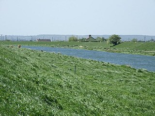
Deeping Fen is a low-lying area in the South Hollanddistrict of Lincolnshire, England, which covers approximately 47 square miles (120km2). It is bounded by the River Welland and the River Glen, and is extensively drained, but the efficient drainage of the land exercised the minds of several of the great civil engineers of the 17th and 18th centuries.
Drainage schemes were first authorised during the reign of Queen Elizabeth I, but from 1632, a group of adventurers took control of the drainage, in return for which they were granted land. They faced the problem that the outfalls of the River Welland and the River Glen were not sufficiently low to enable proper drainage by gravity, and most schemes included improvement to the rivers. John Perry, an engineer of some repute, who had set the standard for engineering reports in 1727, began work in 1730, and was followed by John Grundy, Sr., a pioneer in applying scientific principles to civil engineering problems. His son, John Grundy, Jr., was another capable engineer, who was retained as a consultant after he resigned as full-time Surveyor of Works.
In 1800 the civil engineers William Jessop and John Rennie assisted local engineers with plans for improvements, the chief of which was for a steam pumping station. This plan was not implemented immediately, but two steam engines fitted with scoop wheels were installed at Pode Hole in 1823. The pumping station was the largest in the Fens at the time, and remained so for many years. Steam gradually gave way to diesel engines and scoop wheels were replaced by centrifugal pumps, and the diesel engines were then replaced by electric motors. However, the beam engine and scoop wheel at Pinchbeck Marsh, which ran from 1833 to 1952, was not scrapped, and can be visited by the public.
Deeping Fen is a low-lying area bounded by the River Welland and the River Glen, which meet at its northern tip, covering around 47 square miles (120km2).[2] It was originally an extra-parochial liberty, as it was formed of waste land which had previously belonged to a number of other parishes, but because it had been reclaimed by Adventurers, was free from land tax and ecclesiastical tithes.[3] About half of the fen became the parish of Deeping St Nicholas in 1846, which became a civil parish in reforms authorised by an act of Parliament of 1856.[4]
The name of the fen is derived from the Old English 'Deoping', which means a "deep or low place". The village was listed as "Estdeping" in the Domesday Book, an inventory of the country compiled in 1086.[5]
History
The Map of Deeping Fenne from "The history of imbanking and drayning" by William Dugdale (1662).
People of Market Deeping, Deeping Gate and Deeping St James, together with other villages along the River Welland, presented a petition to Elizabeth I, requesting that the fens should be drained, as the banks of the river and of the neighbouring River Glen were in a poor state of repair. They suggested that Thomas Lovell should undertake the work, which he did, at a cost of £12,000, for which he received 15,000 acres (6,100ha) of the land which was reclaimed as a result of the work. Unrest in the early 1600s resulted in most of the works being destroyed,[6] but in 1632 a group of adventurers led by the Earl of Bedford were granted permission to drain Deeping Fen, South Fen and Croyland. The work included making the Welland deeper and wider from Deeping St James to its outfall beyond Spalding, and the construction of side drains. These included a drain running from Pode Hole to below Spalding, which is still known as Vernatt's Drain, after one of the adventurers called Sir Philibert Vernatti. Although declared completed in 1637, efficient drainage would have to wait until the construction of Pode Hole pumping station in 1827.[7]
The drainage of the fen was again addressed in 1664, when the Deeping Fen Act awarded the Earl of Manchester and others 10,000 acres (4,000ha) of land in return for the drainage works. They were also obliged to maintain the banks of the Welland. The inadequacy of its outfall and a spate of bad weather stopped them from completing their task. They tried renting out the land they had been granted, but many tenants were unable to pay the rent, due to the poor state of the drainage which reduced crop yields.[8] In April 1729, the Deeping Fen Adventurers received a letter from Captain John Perry, expressing the opinion that the only way to improve the drainage was to improve the river outfalls, and proposing the construction of scouring sluices on the river at Spalding, on Vernatt's drain at its outfall, and on the River Glen at Surfleet. Perry was an engineer of some repute, who had set the standard for engineering reports in 1727, when he published his recommendations for the North Level of the Fens. His plans were approved, and the Adventurers offered to give him land covering nearly 6,000 acres (2,400ha) in payment for the work. He sold one third of the land to finance the project, and began work in 1730. Cowbit sluice on the Welland had six 6-foot (1.8m) wide gates which were operated by chains connected to a treadwheel. At high tide, water was penned in Cowbit Wash, between banks which were set well back from the main channel. At low tide, the sluice gates were opened, and the flow scoured out silt from the river bed for some 3 miles (4.8km) downstream. Perry died in February 1733, before the other works were completed, and was buried in Spalding churchyard.[9]
Scientific drainage
Perry was succeeded by John Grundy, Sr., who had arrived in the region in 1731 at the request of the Duke of Buccleuch, who wanted his estates surveyed. Perry was building the Spalding sluice at the time, and Grundy's work allowed him to study drains, banks, sluices and outfalls. He formed the opinion that mathematical and philosophical principles should be applied to the drainage of low-lying regions. In 1733, he surveyed the parish of Moulton, a little further downstream, to assess how drainage could be improved for the Commissioners of Sewers. He demonstrated the use of a telescopic spirit level, which enabled him to achieve accurate levels, with errors of less than 1 inch per mile (2cm per km). Next he addressed the issue of flow in open drains. Using his mathematical principles, he calculated that water in a drain which was 4 miles (6.4km) long, and had a fall of 12 inches (30cm) over its length should travel at around 4 feet per second (1.2m/s), taking 1 hour and 28 minutes to travel the length of the drain. Observations in the field showed him that other factors, such as fluid friction, resulted in the actual flow rate being less than half of this. He published a paper of his findings in April 1734, and insisted that accurate mapping and levels, together with physical observation of drains and rivers, were essential to deciding how fenland could best be drained. In the same month, he began working for the Adventurers of Deeping Fen, to produce a drainage scheme. He spent some time mapping 22 miles (35km) of the Welland, and his chief recommendation was for a reservoir and sluice at the outfall of the River Glen, which would enable the outfall to be scoured at low tide, by releasing water from the reservoir.[10]
An Act to enable the Adventurers, Owners, and Proprietors, of the Taxable Lands, and the Owners and Proprietors of the Free Lands, in Deeping Fens, and other Fens, in the County of Lincoln, therein mentioned, to raise a competent Sum of Money, for the effectual Draining and future Preservation of all the said Fens, according to their Agreement in that Behalf, and to carry the said Agreement into Execution; and for other Purposes therein mentioned.
In July 1737 Grundy and Humphry Smith set out their plans for the fen, and a bill was put before Parliament, to allow the Adventurers to raise the £15,000 estimated cost by taxes. The act was granted in 1738, and Smith and Grundy were appointed "Surveyors and Agents of Deeping Fen." They oversaw a programme of repairs to the Deeping Bank, which ran for 12 miles (19km) along the south-eastern edge of the fen, protecting it from the Welland. John Scribo did the same for the Country Bank, which ran for 6 miles (9.7km) on the far side of the river. Grundy made the river deeper above Spalding, and also constructed a sluice and reservoir at the mouth of the Glen. The reservoir covered 8 acres (3.2ha) and provided water to scour the channel below the sluice. Two drainage mills were constructed, each with a 16-foot (4.9m)scoop wheel, one on Vernatt's Drain and the other on Hill's Drain. The bed of the Glen had also been regraded and its banks raised by 1742, when Smith retired and Grundy took sole charge of the works. He oversaw the job of making the Welland through Spalding deeper and wider, and suggested that the outfall of Vernatt's Drain should be moved 2.5 miles (4.0km) downstream from its existing position. Although not implemented immediately, his son completed this task in 1774. Grundy died in 1748, having been a pioneer in applying scientific principles to civil engineering problems.[2]
Civil engineers
John Grundy, Jr., took over as Surveyor of Works after the death of his father in 1748, and spent nearly £10,000 on repairs to the Deeping Bank and the Country bank between then and 1764. He rebuilt Perry's sluice on the Welland soon after 1750, with taller doors and a set of tide gates to prevent the tide moving upstream. In 1755 three more drainage mills were built on Hills Drain, while a sluice on the Forty Foot Drain followed in 1758. From 1759 to 1761 he was engaged in lowering the bed of the Welland below the outfall sluice by 2.5 feet (0.76m). After 1764, Thomas Hogard became the Surveyor of Works, but Grundy continued to act as a consultant engineer.[11]
Hogard devised a scheme to cut a new channel from the junction of the Welland and the Glen to Wyberton, on the estuary of the River Witham below Boston. At the end of the 7.5-mile (12.1km) cut, there would be a huge sluice and a navigation lock. The Adventurers asked Thomas Tofield for a second opinion, who suggested a shorter 5-mile (8.0km) cut from Spalding to Fosdyke. They requested help from Grundy, who proposed a 1.5-mile (2.4km) cut to Fosdyke, and that the outfall of Vernatt's drain should be moved downstream as his father had suggested. Improvements to the drain were carried out under an act of Parliament obtained in 1774, and an act was obtained in 1794 to sanction the Wyberton cut, although the work was not carried out, and Grundy's shorter cut was built under a new act of 1801.[12]
The fen was inundated in 1798, and the civil engineers William Jessop and John Rennie were asked to assist the local engineers Edward Hare and George Maxwell. There was a clear understanding that the outfalls were too high to allow proper drainage by gravity, and two possible solutions were considered. The first was an outfall at a lower level, which would involve hugh expense in its construction, and the second, favoured by Jessop and Rennie, was the provision of steam pumping engines at Pode Hole. These would pump water from the internal drains of the fen to Vernatt's Drain, and the lower internal water levels would allow the existing wind-powered drainage mills to work efficiently.[13] A report was produced, which formed the basis for the Deeping Fen Act 1801. The channel of the Welland above Spalding was made deeper, the north bank was made stronger, and the North and South Drove Drains which crossed the fen to join Vernatt's Drain at Pode Hole were made deeper.[14] At the time there were no steam engines working in the fens, and Rennie's recommendation of a steam pumping station at Pode Hole was not implemented.[13]
Pumping stations
After reports by Rennie and Thomas Pear in 1815, and by Rennie alone in 1818 and 1820, the provision of steam engines was authorised by an act in 1823.[14] The land which formed the North Drove was at a lower level to that in the South Drove, and so it was intended to keep the water at different levels in each drain, so that a less powerful engine could be built to pump the South Drove Drain. By the time the details had been finalised, engines of 60hp (45kW) and 80hp (60kW) were ordered.[15] Both engines were beam engines. The larger one was manufactured by Butterley, was called the Holland engine, and drove a scoop wheel which was 28 feet (8.5m) in diameter. The wheel had 40 scoops and lifted the water by 5 feet (1.5m). The smaller engine, which was called the Kesteven engine, was made by Fenton & Murrey, and drove a similar scoop wheel.[16] They were operational by August 1825, having cost £26,673. The pumping station was the largest in the Fens at the time, and remained so for many years.[15]
Upgrading of the plant occurred several times. The Kesteven and Holland engines were overhauled in 1881 and 1883 respectively. Flow into the wheel pits was restricted by the provision of shuttles, and rising breasts were fitted on the outflow, so that the height at which the water was discharged could be varied as the water level in Vernatt's drain varied. Five new boilers, which could supply either engine, were fitted in 1883, and had been replaced by five more some time before 1928, for the new boilers failed in that year. The Kesteven engine had its scoop wheel removed, although the rest of the plant was not scrapped until 1952.[16]
Two 100hp (75kW) twin-cylinder diesel engines were installed to aid the steam plant, the first in 1914 and the second in 1920. They were made by Mirrlees, and were scrapped in 1956. Following the demise of the steam engines, a Mirrlees 250hp (190kW) five-cylinder diesel engine, which drove a 54-inch (140cm) pump was obtained. The first electric pump was installed in 1939, to be joined by three more in 1957, once the Mirrlees engines had been decommissioned. A new engine house was built in 1964, which held two 650hp (480kW) Ruston diesel engines driving 60-inch (150cm)Gwynnes Limited pumps, and a third 410hp (310kW) Ruston unit, fitted with a 50-inch (130cm) Gwynnes pump. The remaining Mirrlees engine and the first electric pump were scrapped at this time.[17]
Other districts
Pinchbeck South Fen is a region covering 1,700 acres (690ha) lying on the west side of Vernatt's Drain. It was originally managed as the Fourth District by the Deeping Fen trustees, but was independent in 1828, when the occupants approached the trustees with a plan to drain some of the water from the fen to the Pode Hole pumps. A tunnel already existed under Vernatt's drain, and so the trustees agreed. However, the charges levied by the trustees for this service rose dramatically, so that the South Fen residents decided to build their own pumping engine at Pode Hole in 1830. A Fenton & Murray beam engine driving a 20-foot (6.1m) scoop wheel was installed, at a cost of £3,000, which was considerably less than the charge the trustees wanted to make. The engine was replaced by a suction gas engine and Ruston pump in 1919, which was decommissioned in 1943 when a Petter oil engine with a 20-inch (51cm) Gwynnes pump was installed. This only lasted for ten years, as two electric motors driving 24-inch (61cm) and 20-inch (51cm) pumps were fitted in 1953.[18]
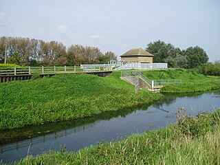
Pinchbeck Marsh was also part of Deeping Fen, but following the failure of the work carried out under the 1801 Act to effectively drain the area, an act of Parliament was obtained in 1832 to create a separate district, called the Spalding and Pinchbeck District, or Blue Gowt, as water from the 6,000 acres (2,400ha) feeds into the River Glen from the Blue Gowt Drain. A 20hp (15kW) Butterley beam engine driving a 22-foot (6.7m) scoop wheel was installed in 1833. Although a new boiler was installed in 1895, the engine and wheel continued to operate until 1952, making it the last beam engine and scoop wheel combination to be used in the Fens, and also the one which ran for the longest time. Its function was replaced by the two electric pumps fitted in 1953, which also pump the Pinchbeck South Fen, but the plant was retained, and is now open to the public, although the steam engine is now turned by an electric motor.[19]
The management of Deeping Fen by trustees, appointed under the terms of the 1801 Act, continued until they were replaced in 1939 by the Deeping Fen, Spalding and Pinchbeck Internal Drainage Board,[14] which became part of the Welland & Deepings Internal Drainage Board, when it amalgamated with three other local internal drainage boards in 1973.[20]
Mills, A. D. (1998). A Dictionary of English Place-Names. Oxford University Press. ISBN978-0-19-280074-9.
Raithby, John, ed. (1819). Statutes of the Realm. Vol.5: 1628–80. pp.559–568, Charles II, 1664 & 1665, An Act for drayning of the Fenn called Deeping Fenn and other Fenns therin mentioned.
Skempton, Sir Alec; etal. (2002). A Biographical Dictionary of Civil Engineers in Great Britain and Ireland: Vol 1: 1500 to 1830. Thomas Telford. ISBN978-0-7277-2939-2.
Related Research Articles
The River Witham is a river almost entirely in the county of Lincolnshire in the east of England. It rises south of Grantham close to South Witham at SK8818, passes through the centre of Grantham, passes Lincoln at SK9771 and at Boston, TF3244, flows into The Haven, a tidal arm of The Wash, near RSPB Frampton Marsh. The name "Witham" seems to be extremely old and of unknown origin. Archaeological and documentary evidence shows the importance of the Witham as a navigable river from the Iron Age onwards. From Roman times it was navigable to Lincoln, from where the Fossdyke was constructed to link it to the River Trent. The mouth of the river moved in 1014 following severe flooding, and Boston became important as a port.
The River Welland is a lowland river in the east of England, some 65 miles (105 km) long. It drains part of the Midlands eastwards to The Wash. The river rises in the Hothorpe Hills, at Sibbertoft in Northamptonshire, then flows generally northeast to Market Harborough, Stamford and Spalding, to reach The Wash near Fosdyke. It is a major waterway across the part of the Fens called South Holland, and is one of the Fenland rivers that were laid out with washlands. There are two channels between widely spaced embankments with the intention that flood waters would have space in which to spread while the tide in the estuary prevented free egress. However, after the floods of 1947, new works such as the Coronation Channel were constructed to control flooding in Spalding, and the washlands are no longer used solely as pasture, but may be used for arable farming.
The Old Bedford River is an artificial, partial diversion of the waters of the River Great Ouse in the Fens of Cambridgeshire, England. It was named after the fourth Earl of Bedford who contracted with the local Commission of Sewers to drain the Great Level of the Fens beginning in 1630. It provided a steeper and shorter path for the waters of the Great Ouse, and was embanked to prevent them flooding the low ground of the South Fens. Throughout the project, the Earl and his Adventurers faced disruption from those who were opposed to drainage schemes. The project was deemed to have succeeded in draining the fens in 1637, but that decision was reversed in 1638. After a lull during the English Civil War, when much of the work was damaged, the Dutch engineer Cornelius Vermuyden worked with William Russell, the fifth Earl of Bedford to complete the drainage. Disruption and unrest continued while the work was carried out, resulting in the Adventurers employing armed guards. A second river, the New Bedford River, was cut parallel to the first channel, which then became the Old Bedford River. At some point, the Old Bedford River was split into two parts, when the upper section was diverted into the River Delph at Welches Dam, and the lower section was joined to the Counter Drain. Both parts retain the name, but are not connected to each other. The area between the two Bedford rivers acts as a large washland, which holds floodwater when the river channels cannot cope with the volume of water in them.
The River Glen is a river in Lincolnshire, England with a short stretch passing through Rutland near Essendine.
The Haven is the tidal river of the port of Boston, Lincolnshire in England. It provides access for shipping between Boston Deeps in The Wash and the town, particularly, the dock. It also serves as the outfall into the sea of the River Witham and of several major land drains of the northern Fens of eastern England, which are known collectively as the Witham Navigable Drains.
The South Forty-Foot Drain, also known as the Black Sluice Navigation, is the main channel for the land-drainage of the Black Sluice Level in the Lincolnshire Fens. It lies in eastern England between Guthram Gowt and the Black Sluice pumping station on The Haven, at Boston. The Drain has its origins in the 1630s, when the first scheme to make the Fen land available for agriculture was carried out by the Earl of Lindsey, and has been steadily improved since then. Water drained from the land entered The Haven by gravity at certain states of the tide until 1946, when the Black Sluice pumping station was commissioned.
Bourne Eau is a short river which rises from an artesian spring in the town of Bourne in Lincolnshire, England, and flows in an easterly direction to join the River Glen at Tongue End. Within the town, it once powered three water mills, one of which is now a heritage centre. At Eastgate, it becomes much wider as it was navigable in the 18th and 19th centuries, and this was the location of the terminal basin. Below the town it is an embanked river, as its normal level is higher than that of the surrounding Fens. Navigation ceased in the 1860s and the river now forms an important part of the drainage system that enables the surrounding fen land to be used for agriculture.
The Forty Foot or Forty Foot Drain is a name given to several of the principal channels in the drainage schemes of the Fens of Eastern England, the name being qualified when there is a need to distinguish between them. They are Vermuyden's Drain, South Forty Foot and North Forty Foot.
The Middle Level Navigations are a network of waterways in England, primarily used for land drainage, which lie in The Fens between the Rivers Nene and Great Ouse, and between the cities of Peterborough and Cambridge. Most of the area through which they run is at or below sea level, and attempts to protect it from inundation have been carried out since 1480. The Middle Level was given its name by the Dutch Engineer Cornelius Vermuyden in 1642, who subsequently constructed several drainage channels to make the area suitable for agriculture. Water levels were always managed to allow navigation, and Commissioners were established in 1754 to maintain the waterways and collect tolls from commercial traffic.
The Fens Waterways Link is a project to improve recreational boating opportunities in the counties of Cambridgeshire and Lincolnshire, England. By a combination of improvements to existing waterways and the construction of new links a circular route between Lincoln, Peterborough, Ely and Boston is planned. The project is being organised by the Environment Agency and financed from the Regional Development Agency and the European Union.
Pinchbeck is a village and civil parish in the South Holland district of Lincolnshire, England. The civil parish population was 5,153 at the 2001 census, 5,455 at the 2011 census and 6,011 at the 2021 census. It is situated 2 miles (3.2 km) north from the centre of Spalding.
A scoop wheel or scoopwheel is a pump, usually used for land drainage.
The Witham Navigable Drains are located in Lincolnshire, England, and are part of a much larger drainage system managed by the Witham Fourth District Internal Drainage Board. The Witham Fourth District comprises the East Fen and West Fen, to the north of Boston, which together cover an area of 97 square miles (250 km2). In total there are over 438 miles (705 km) of drainage ditches, of which under 60 miles (97 km) are navigable. Navigation is normally only possible in the summer months, as the drains are maintained at a lower level in winter, and are subject to sudden changes in level as a result of their primary drainage function, which can leave boats stranded. Access to the drains is from the River Witham at Anton's Gowt Lock.
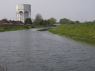
Pode Hole is a village in South Holland, Lincolnshire, England. It is 2 miles (3.2 km) from Spalding and 10 miles from Bourne. The village lies at the confluence of several drainage channels, where two pumping stations discharge water into Vernatt's Drain from land in Deeping Fen to the South and West. Water from Pinchbeck South Fen to the North is also lifted into Vernatt's Drain. The village arose to service the pumping stations.
The Pinchbeck Engine is a drainage engine, a rotative beam engine built in 1833 to drain Pinchbeck Marsh, to the north of Spalding, Lincolnshire, in England. Until it was shut down in 1952, the engine discharged into the Blue Gowt which joins the River Glen at Surfleet Seas End.
Guthram Gowt is a small settlement in the South Holland district of Lincolnshire, England. It is situated 5 miles (8 km) both east from Bourne and west from Spalding, and at a bend in the River Glen.
John Grundy Jr. (1719–1783) was an English civil engineer, who worked on a number of drainage schemes, canal projects and dock works. He lived in Spalding, Lincolnshire, from 1739. Part of his legacy was his Report Books, seventeen volumes containing copies of his reports and other supporting documents from most of his projects, which in some cases are the only surviving records of major civil engineering projects. They were re-discovered in 1988.
John Grundy, Sr. was a teacher of mathematics, a land surveyor, and later a civil engineer. Grundy lived in Congerstone, Leicestershire, England for the first forty years of his life; he later moved to Spalding in Lincolnshire. He was one of the first engineers to apply mathematical principles to the problems of land drainage. His son, John Grundy Jr., was also a civil engineer.
South Holland IDB is an English internal drainage board set up under the terms of the Land Drainage Act 1930. It has responsibility for the land drainage of 148.43 square miles (384.4 km2) of low-lying land in South Lincolnshire. It is unusual as its catchment area is the same as the area of the drainage district, and so it does not have to deal with water flowing into the area from surrounding higher ground. No major rivers flow through the area, although the district is bounded by the River Welland to the west and the River Nene to the east.
Holderness Drain is the main feature of a land drainage scheme for the area of Holderness to the east of the River Hull in the East Riding of Yorkshire, England. Construction began in 1764, and several notable civil engineers were involved with the scheme over the years. Despite the high costs of the initial scheme, it was not particularly successful, because of the refusal of the ship owners of Hull to allow an outlet at Marfleet. They insisted that the water be discharged into the River Hull to keep the channel free of silt. Following a period of agricultural depression and the building of new docks in the early 1800s, an outlet at Marfleet was finally authorised in 1832. A high level system still fed upland water to the Hull, but the low level system discharged into the Humber, where levels were considerably lower. Following the success of steam pumping on the Beverley and Barmston Drain, the trustees looked at such a possibility for the Holderness Drain, but the development of the Alexandra Dock in the 1880s and then the King George V Dock in 1913 provided a solution, as the docks were topped up with water pumped from the drain, to lessen the ingress of silt-laden water.
Length of drains maintained(PDF). Deeping Fen, Spalding & Pinchbeck internal drainage board. 1943. Archived from the original(PDF) on 22 October 2013. Retrieved 22 October 2013.
This page is based on this Wikipedia article Text is available under the CC BY-SA 4.0 license; additional terms may apply. Images, videos and audio are available under their respective licenses.