Crowland or Croyland is a town in the South Holland district of Lincolnshire, England. It is situated between Peterborough and Spalding. Crowland contains two sites of historical interest, Crowland Abbey and Trinity Bridge.

The River Welland is a lowland river in the east of England, some 65 miles (105 km) long. It drains part of the Midlands eastwards to The Wash. The river rises in the Hothorpe Hills, at Sibbertoft in Northamptonshire, then flows generally northeast to Market Harborough, Stamford and Spalding, to reach The Wash near Fosdyke. It is a major waterway across the part of the Fens called South Holland, and is one of the Fenland rivers which were laid out with washlands. There are two channels between widely spaced embankments with the intention that flood waters would have space in which to spread while the tide in the estuary prevented free egress. However, after the floods of 1947, new works such as the Coronation Channel were constructed to control flooding in Spalding and the washes are no longer used solely as pasture, but may be used for arable farming.

Market Deeping is a market town and civil parish in the South Kesteven district of Lincolnshire, England, on the north bank of the River Welland and the A15 road. The population of the town at the 2011 census was 6,008.

Sutton is a small village and civil parish in the Peterborough district, in the north-west of Cambridgeshire, England. Situated about 5.7 miles from Peterborough and approximately half a mile south of the A47 road.

Maxey is a village in the Peterborough unitary authority, in the ceremonial county of Cambridgeshire, England, located between Peterborough and Stamford and southwest of The Deepings. It is home to nearly 700 residents.
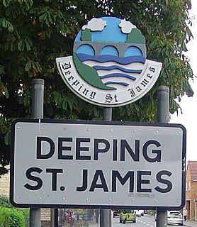
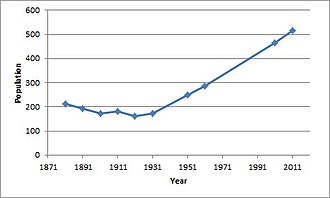
Deeping St James is a large village in the South Kesteven district of Lincolnshire, England. The population of the civil parish was reported as 7,051 at the 2011 census.
The Deepings are a series of settlements close to the River Welland near the borders of southern Lincolnshire and north western Cambridgeshire in eastern England. Peterborough is about 8 miles to the south, Spalding about 10 miles to the north east and Stamford about 8 miles to the west.
Winwick is a village and civil parish in Cambridgeshire, England. Winwick lies approximately 10 miles (16 km) north-west of Huntingdon. It is a crossroads village on the B660 near Hamerton. Winwick is situated within Huntingdonshire which is a non-metropolitan district of Cambridgeshire as well as being a historic county of England.
Chesterton is a small village and civil parish of exactly 56 households in Cambridgeshire, England. The village lies approximately 5 miles (8 km) west-southwest of central Peterborough, near the city's Alwalton district. Chesterton is situated within Huntingdonshire which is a non-metropolitan district of Cambridgeshire as well as being a historic county of England.
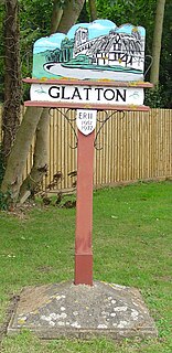
Glatton is a village and civil parish in Cambridgeshire, England, some 8 miles (13 km) south-west of Peterborough, near the villages of Conington, Yaxley and Stilton. It lies in the non-metropolitan district of Huntingdonshire, which is part of Cambridgeshire as well as being a historic county. A World War II airfield built nearby is now known as Peterborough's Conington Airport.
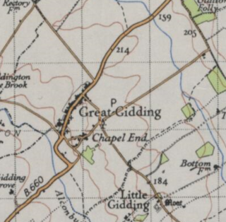
Great Gidding is a village and civil parish in the Huntingdonshire district of Cambridgeshire, England.

Thurlby is a village and civil parish in the South Kesteven district of Lincolnshire, England. It is situated just west of the A15 road, 2 miles (3 km) south from the town of Bourne, and on the edge of the Lincolnshire Fens. It is sometimes referred to as Thurlby by Bourne to distinguish it from other villages in Lincolnshire with the same name. Thurlby and the hamlet of Northorpe to its north are conjoined. The parish had a population of 2,136 at the 2001 census and 2,153 at the 2011 census.

Bainton is a village and civil parish in the Peterborough unitary authority area of Cambridgeshire, England. Bainton is on the southern edge of the Welland valley and lies 7.4 miles (11.9 km) north-west of Peterborough and 4 miles (6.4 km) east of Stamford. Ashton is a neighbouring hamlet and lies approximately 1 mile (1.6 km) south-east of Bainton within the same civil parish. At the time of the 2001 census, the parish's population was 305 people and by the 2011 census the parish's population was 290 people.

Borough Fen is a civil parish in the City of Peterborough unitary authority in Cambridgeshire, England. The parish is to the north of Peterborough city centre, just below the county border with Lincolnshire. Much of the land in the 19th century was owned by Sir Culling Eardley, 3rd Baronet, a strong supporter of the local boys' school. The land has predominantly been used for agriculture and cattle farming which is still a significant employment sector today.
Described by John Marius Wilson in 1870 as "BOROUGH-FEN (Ville), an extra-parochial tract in Peterborough district, Northampton; 5 miles N by E of Peterborough. Acres, 3,130. Real property, £6,086. Pop., 202. Houses, 31."
Earith is a village and civil parish in Cambridgeshire, England. Earith lies approximately 10 miles (16 km) east of Huntingdon. Earith is situated within Huntingdonshire which is a non-metropolitan district of Cambridgeshire as well as being a historic county of England. At Earith, two artificial diversion channels of the River Great Ouse, the Old Bedford River and the New Bedford River, leave the river on a course to Denver Sluice near Downham Market, where they rejoin the Great Ouse in its tidal part. At the 2001 census, the parish had a population of 1,677, reducing to 1,606 at the 2011 Census.

Langtoft is a village and civil parish in the South Kesteven district of Lincolnshire, England. The population of the civil parish at the 2011 census was 2,045. It lies on the A15 road, about 10 miles (16 km) north from Peterborough and about 8 miles (13 km) east from Stamford, and on the edge of The Fens.
Cowbit is a village and civil parish in the South Holland district of Lincolnshire, England. The population of the civil parish at the 2011 census was 1,220. It is situated 3 miles (5 km) south from Spalding and 5 miles (8 km) north from Crowland.
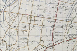
Newborough is a village and a civil parish in the Peterborough district, in the ceremonial county of Cambridgeshire, England. Newborough is situated 7.62 km (4.74 mi) north of Peterborough. Newborough has a population of 1,670 according to the 2011 census

Marholm is a village and civil parish in the Peterborough district, in the ceremonial county of Cambridgeshire, England. West of Peterborough and 1 mile from the seat of the Fitzwilliam family at Milton Hall. The parish covers some 1,400 acres, with the village positioned roughly in the centre. For electoral purposes it forms part of Northborough ward in North West Cambridgeshire constituency.

Deeping St Nicholas is a village near Spalding in Lincolnshire, England, on the A1175 road between The Deepings and Spalding. Unlike Market Deeping, which is in South Kesteven district, Deeping St Nicholas is in South Holland.