Borough Fen

Last updated

Borough Fen
Cambridgeshire UK location map.svg
Red pog.svg
Borough Fen
Location within Cambridgeshire
Population126 (2011 census) [1]
Unitary authority
Ceremonial county
Region
Country England
Sovereign state United Kingdom
Post town Peterborough
Postcode district PE6
List of places
UK
England
Cambridgeshire
52°39′25″N0°13′01″W / 52.657°N 0.217°W / 52.657; -0.217 Coordinates: 52°39′25″N0°13′01″W / 52.657°N 0.217°W / 52.657; -0.217
Borough Fen Map 1856 Borough Fen Map 1856.jpg
Borough Fen Map 1856

Borough Fen is a civil parish in the City of Peterborough unitary authority in Cambridgeshire, England. The parish is to the north of Peterborough city centre, just below the county border with Lincolnshire. Much of the land in the 19th century was owned by Sir Culling Eardley, 3rd Baronet, a strong supporter of the local boys' school. [2] The land has predominantly been used for agriculture and cattle farming which is still a significant employment sector today.

Contents

Described by John Marius Wilson in 1870 as "BOROUGH-FEN (Ville), an extra-parochial tract in Peterborough district, Northampton; 5 miles N by E of Peterborough. Acres, 3,130. Real property, £6,086. Pop., 202. Houses, 31." [3]

Local area

There are 54 dwellings in the Parish of Borough Fen. All but one of the dwellings are whole houses, bungalows, or semi-detached houses. This a similar pattern across the region in nearby Peterborough and the East of England as a whole where the percentage of whole houses is very high. Borough Fen is a very green and open parish with large farmhouses. There are no terraced urban-style roads and no apartment buildings. [4] There is a lack of retail shops in the parish, although they can be found in the neighbouring towns of Crowland and Newborough.

History

Population

Before 1811 the nearby Parish of Newborough was a tract called Borough Fen Common. Once Newborough became a parish some of the population was returned to Borough Fen explaining the rise in population between 1801 and 1811 shown in the population graph below. [5] Population increased substantially between 1921 and 1931 a key era in the further industrialisation of England. This population rise coincides with the creation of The London Brick Company in Peterborough who by 1935 were producing 60% of the local industry output employing workers in the surrounding areas. [6]

Today the largest age group in Borough Fen is the 45–59 group holding 34.9% of the population in 2011. [7] This coincides with the fact that the majority of households do not have children suggesting that the main bulk of the local population are nearing retirement with no offspring or offspring who have left home. [8] This is comparable to the statistics in the surrounding area of Peterborough.

Borough Fen Population Borough Fen Population.jpg
Borough Fen Population

Industry and employment

Local industry and the work force of Borough Fen has changed over time. In 1881 the majority of employed residents in Borough Fen (87.5%) [11] were employed in the agricultural sector. This was normal for rural areas of England in the late 19th century, in comparison Peterborough's largest employment sector was also agriculture.

A table showing the employment data for Borough Fen in 1881. Borough Fen Employment Data (1881).jpg
A table showing the employment data for Borough Fen in 1881.

Due to the industrialisation of agriculture, today fewer Borough Fen residents are employed in the agricultural sector. At the 2011 census the number only stood at 16.2% of all employed residents. This shift can be explained by the rise of the retail and mechanical sectors, which now hold 21.2% of local employment, the highest of any sector. [13]

Energy Farm Plan

In March 2013 a plan was put forward for a collection of wind and solar farms in Newborough Farm (part of Borough Fen), along with nearby America Farm and Morris Fen. They were expected to cost around £200 million covering 900 acres of Peterborough farmland, the council claimed they would bring in £100 million over 25 years. However, in 2014 due to a change in government energy tariffs and a lack of support for the plan led to the project being scrapped. [14]

Historic sites

Borough Fen has two notable historic features. The older of the two features is the duck decoy located on the west side of the parish, supposedly one of the oldest in England. The decoy was in operation intermittently between 1776 and 1959, catching primarily mallard, and can be seen via tours from the local farm. [15] There is also World War II pillbox fortification, built in 1940 as a component of the British anti-invasion preparations.

Borough Fen Pill Box Pill Box, Speechley's Drove, Borough Fen, Peterborough - geograph.org.uk - 132939.jpg
Borough Fen Pill Box

Related Research Articles

Sutton, Peterborough Human settlement in England

Sutton is a small village and civil parish in the Peterborough district, in the north-west of Cambridgeshire, England. Situated about 5.7 miles from Peterborough and approximately half a mile south of the A47 road.

Acton Turville Human settlement in England

Acton Turville is a parish in the Cotswold Edge ward within South Gloucestershire, England. It lies 17 miles (27 km) east-northeast of Bristol and 93 miles (150 km) due west of London, with the M4 south of the parish. Acton Turville consists of a cluster of households across 1,009 acres, with a total population of 370 people. Acton Turville is also listed as "Achetone" in the Domesday Book.

High Laver Human settlement in England

High Laver is a village and civil parish in the Epping Forest district of the county of Essex, England. The parish is noted for its association with the philosopher John Locke.

Kilby Human settlement in England

Kilby is a village and civil parish in the Blaby district of Leicestershire, England. Kilby is the easternmost village in the district, and is 6.1 miles (9.8 km) south east of Leicester. Kilby civil parish includes the former parish of Foston and it's deserted medieval village. Nearby places are Countesthorpe 2.21 miles (3.56 km), Fleckney 2.12 miles (3.41 km), Arnesby 1.96 miles (3.15 km), Wistow 1.4 miles (2.3 km) and Kilby Bridge 1.18 miles (1.90 km).

Thorney, Cambridgeshire Human settlement in England

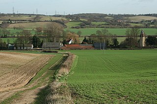
Thorney is a village in the Peterborough unitary authority in the ceremonial county of Cambridgeshire, England. Located around eight miles (13 km) east of Peterborough city centre, on the A47.

Beetley Village and civil parish in the Breckland district of Norfolk, England

Beetley is a village and civil parish in the Breckland district of Norfolk, England. According to the 2011 census the parish had a population of 1,396. The village is situated four miles (6 km) north of East Dereham.

Newborough, Cambridgeshire Human settlement in England

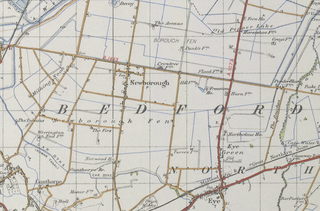
Newborough is a village and a civil parish in the Peterborough district, in the ceremonial county of Cambridgeshire, England. Newborough is situated 7.62 km (4.74 mi) north of Peterborough. Newborough has a population of 1,670 according to the 2011 census

Marholm Human settlement in England

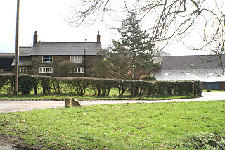
Marholm is a village and civil parish in the Peterborough district, in the ceremonial county of Cambridgeshire, England. West of Peterborough and 1 mile from the seat of the Fitzwilliam family at Milton Hall. The parish covers some 1,400 acres, with the village positioned roughly in the centre. For electoral purposes it forms part of Northborough ward in North West Cambridgeshire constituency.

Heveningham Village in Suffolk, England

Heveningham is a village and civil parish in the East Suffolk district of Suffolk in eastern England. Located four miles south-west of Halesworth, in 2005 it had a population of 120.

Clopton, Suffolk Human settlement in England

Clopton is a village and civil parish in Suffolk. It is located between Ipswich and Debenham two kilometres north of Grundisburgh on the River Lark. The village is no larger than a series of houses either side of the B1078, surrounded by farm land. The village itself has no clear centre; houses and other buildings are concentrated around the four manors of Kingshall, Brendhall, Rousehall and Wascolies, all of which are mentioned in the Domesday Book of 1086.

Worlingworth Village in Suffolk, England

Worlingworth is a village and civil parish in the Mid Suffolk district of Suffolk in eastern England, located around ten miles south-east of Diss. In 2011 it had a total population of 802 people.

Stanfield, Norfolk Human settlement in England

Stanfield is a civil parish in the English county of Norfolk. It covers an area of 3.80 km2 (1.47 sq mi) and had a population of 162 in 2011, and 144 at the 2001 census. For the purposes of local government, it falls within the district of Breckland. Stanfield belongs to the Parliamentary Constituency of Mid-Norfolk and is currently governed by George Freeman as their member of Parliament who is representative of the Conservative Party.

Newborough, Staffordshire Human settlement in England

Newborough is a village and civil parish in the county of Staffordshire, England. It is located 3 miles (5 km) south west of Hanbury and 8 miles (13 km) west of Burton-upon-Trent. Newborough has a pub, a school and a church. At the 2011 UK census, the population stood at 476, comprising 240 males and 236 females. Newborough is part of the Yoxall ward of East Staffordshire.

Dalton, South Yorkshire Civil parish in South Yorkshire, England

Dalton is a civil parish in the Metropolitan Borough of Rotherham in South Yorkshire, England. Dalton is situated 162 miles (260.7 km) north from London and is 2 miles (3.2 km) north-east from the centre of Rotherham town centre. The population of the parish as taken at the 2011 Census was 10,292. The parish includes the communities of Brecks, Dalton Brook, Dalton Foljambe, Dalton Magna, Dalton Parva, Flanderwell, Sunnyside and Woodlaithes.

Millington, Cheshire Human settlement in England

Millington is a civil parish in the Borough of Cheshire East in England. The parish is 8 miles (13 km) from Warrington and 3 miles (5 km) from Altrincham. Its name is a "relic of Saxon clanship – the ton or town of the Millings". The parish is primarily agricultural, with a number of farms including Moss House Farm, Newhall Farm, Mereside Farm, Boothbank Farm and Stonedelph Farm. Millington has been recently described on Britain Streets as a "hamlet or isolated settlement in inhabited countryside". Millington is situated within the market town Macclesfield within the Unitary Authority of Cheshire East. The M56 motorway is close to the parish, which allows travel into areas of Warrington and Manchester, 13 miles (21 km) and 14 miles (23 km) away respectively.

Great Tey Human settlement in England

Great Tey is a village and civil parish near the villages of Marks Tey and Little Tey in the Colchester borough of Essex, England, located approximately six miles west of Colchester.

Lamarsh Human settlement in England

Lamarsh is a village and a civil parish in the Braintree District, in the county of Essex, England. It is near the large village of Bures and the village of Alphamstone. The village is west of the River Stour. It has a pub, a village hall and a church called The Friends of Holy Innocents Church. The civil parish's name, Lamarsh, comes from the phrase "Loamy marsh". This is derived from the Old English terms lām and mersc, which translate into loam or clay and a marsh respectively.

Huntingfield, Suffolk Human settlement in England

Huntingfield is a village near the B1117 road, in the East Suffolk district, in the county of Suffolk, England. The village is close to the source of the River Blyth and the parish is 12 miles from the seaside town of Southwold. Nearby settlements include the town of Halesworth and the villages of Walpole, Heveningham, Cookley and Laxfield.

Standon, Staffordshire Human settlement in England

Standon is a village and civil parish in the Stafford district, in the county of Staffordshire, England. Standon has a church called Church of All Saints and one school called All Saints C of E First School. In 2001 the population of the civil parish of Standon was 823, and in the 2011 census it had a population of 879.

Shobrooke Village in Devon, England

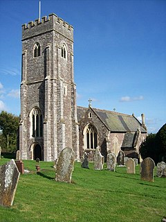
Shobrooke is a village, parish and former manor in Devon, England. The village is situated about 1 1/2 miles north-east of Crediton. It is located close to Shobrooke park. The river Shobrooke Lake flows through the village. It had a population of 537 according to the 2011 census. The name Shobrooke is derived from the old English words of succa and brōc, and translates as goblin brook.

References

  1. "Borough Fen: Key Figures for 2011 Census: Key Statistics". neighbourhood.statistics.gov.uk. Office For National Statistics. Retrieved 27 January 2015.
  2. "Post Office Directory of Berks, Northants... , 1854". specialcollections.le.ac.uk. Kelly & Co. 1854. Retrieved 20 March 2015.
  3. Wilson, John Marius (1870). Imperial Gazetteer of England and Wales. Edinburgh. Retrieved 27 January 2015.
  4. "Borough Fen (Parish): Dwellings, Household Spaces and Accommodation Type, 2011". Neighbourhood Statistics. Office for National Statistics. Retrieved 10 April 2015.
  5. "Population tables I, Vol. I. England and Wales. Divisions I-VII, 1851". www.histpop.org. HMOS. Retrieved 9 March 2015.
  6. Richard, Hillier (1981). Clay that Burns a History of the Fletton Brick Industry.
  7. "Age Structure, 2011". Office for National Statistics. Retrieved 25 March 2015.
  8. "Borough Fen (Parish): Household Composition, 2011". Neighbourhood Statistics. Office for National Statistics. Retrieved 25 March 2015.
  9. "Borough Fen Population". A Vision of Britain through Time. Vision of Britain. Retrieved 28 January 2015.
  10. "Borough Fen (Parish): Census Data". Neighbourhood Statistics/. Office for National Statistics. Retrieved 28 January 2015.
  11. "Occupation data classified into the 24 1881 'Orders', plus sex". A Vision of Britain through Time. Vision of Britain. Retrieved 12 March 2015.
  12. "Borough Fen: Table 10: " Occupations of Males and Females in the Division and its Registration Counties"". A Vision of Britain through Time. Vision of Britain. Retrieved 9 March 2015.
  13. "Borough Fen (Parish): Industry, 2011 (KS605EW)". Neighbourhood Statistics. Office for National Statistics. Retrieved 12 March 2015.
  14. Edwards, Mark. "City council may go ahead with solar farm plan". www.peterboroughtoday.co.uk. Peterborough Telegraph. Retrieved 25 February 2015.
  15. Cook, W.A. "The numbers of ducks caught in Borough Fen Decoy, 1776–1959". wildfowl.wwt.org.uk. Wildfowl. Retrieved 16 March 2015.

Commons-logo.svg Media related to Borough Fen, Cambridgeshire at Wikimedia Commons