
Eynesbury is an urban area in the civil parish of St Neots, in the Huntingdonshire district of Cambridgeshire, England. It mainly consists of housing, although there is an area of light industry, and a large supermarket. In addition there is a large area of open grassland and a caravan park.

Boarstall is a village and civil parish in the Aylesbury Vale district of Buckinghamshire, about 12 miles (19 km) west of Aylesbury. The parish is on the county boundary with Oxfordshire and the village is about 5.5 miles (9 km) southeast of the Oxfordshire market town of Bicester.

Whittlesey is a market town and civil parish in the Fenland district of Cambridgeshire, England. Whittlesey is 6 miles (10 km) east of Peterborough. The population of the parish was 17,667 at the 2021 Census.

Chatteris is a market town and civil parish in the Fenland district of Cambridgeshire, England, situated in the Fens between Huntingdon, March and Ely. The town is in the North East Cambridgeshire parliamentary constituency.
Longthorpe is an area of the city of Peterborough, in the ceremonial county of Cambridgeshire, England. Located two miles (3.2 km) west from the city centre, the area covers 1,390 acres. For electoral purposes it forms part of Peterborough West ward.
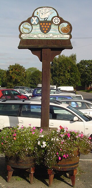
Swavesey is a village lying on the Prime Meridian in Cambridgeshire, England, with a population of 2,463. The village is situated 9 miles to the north west of Cambridge and 3 miles south east of St Ives.

Hemingford Grey is a village and civil parish in Cambridgeshire, England. Hemingford Grey lies approximately 4 miles (6 km) east of Huntingdon. Hemingford Grey is situated within Huntingdonshire which is a non-metropolitan district of Cambridgeshire as well as being a historic county of England.
Sawtry is a village and civil parish in Cambridgeshire, England. Sawtry lies approximately 8 miles (13 km) north of Huntingdon. Sawtry is situated within Huntingdonshire which is a non-metropolitan district of Cambridgeshire as well as being a historic county of England. The village is home to over 6,000 people.

Ambrosden is a village and civil parish in Cherwell, Oxfordshire, England, 3 miles (5 km) southwest of Bicester to which it is linked by the A41 road, and 13 miles (21 km) from Oxford. The 2011 Census recorded the parish's population as 2,248. The parish is bounded by the River Ray to the south, its tributary the River Bure to the west, the outskirts of Bicester to the north and field boundaries to the east.

Abbots Ripton is a village and civil parish in Cambridgeshire, England. Abbots Ripton is situated within Huntingdonshire which is a non-metropolitan district of Cambridgeshire as well as being an historic county of England. Abbots Ripton lies approximately 4 miles (6 km) north of Huntingdon on the B1090.
Bury is a village and civil parish in Cambridgeshire, England. Bury lies approximately 7 miles (11 km) north/north east of Huntingdon and is near to Ramsey and St Ives. Bury is situated within Huntingdonshire which is a non-metropolitan district of Cambridgeshire as well as being a historic county of England.

Bluntisham is a village and civil parish in Cambridgeshire, England. The population of the civil parish at the 2011 census was 2,003. Bluntisham lies approximately 8 miles (13 km) east of Huntingdon. Bluntisham is situated within Huntingdonshire which is a non-metropolitan district of Cambridgeshire as well as being a historic county of England. The villages of Earith, Colne, Woodhurst, and Somersham are all close by.

Buckden is a village and civil parish 3.7 miles (6.0 km) north of St Neots and 4 miles (6.4 km) south-west of Huntingdon, England. It includes the hamlets of Stirtloe and Hardwick. It lies in Huntingdonshire, a non-metropolitan district of Cambridgeshire and a historic county, close to three transport routes of past and present: the River Great Ouse, along its eastern boundary, the Great North Road that once crossed the village, but now bypasses it to the west, and the East Coast Mainline along the eastern side of the Great Ouse valley in the neighbouring parish of The Offords.

Warboys is a large village and civil parish in the Huntingdonshire district of Cambridgeshire, England, 7 miles (11 km) north-east of Huntingdon.
Chesterton is a small village and civil parish of exactly 56 households in Cambridgeshire, England. The village lies approximately 5 miles (8 km) west-southwest of central Peterborough, near the city's Alwalton district. Chesterton is situated within Huntingdonshire which is a non-metropolitan district of Cambridgeshire as well as being a historic county of England.

Somersham is a village and civil parish in Cambridgeshire, England. Somersham lies approximately 9 miles (14 km) east of Huntingdon and 4 miles (6 km) north of St Ives. Somersham is situated within Huntingdonshire which is a non-metropolitan district of Cambridgeshire as well as being a historic county of England.

Bainton is a village and civil parish in the Peterborough unitary authority area of Cambridgeshire, England. Bainton is on the southern edge of the Welland valley and lies 7.4 miles (11.9 km) north-west of Peterborough and 4 miles (6.4 km) east of Stamford. Ashton is a neighbouring hamlet and lies approximately 1 mile (1.6 km) south-east of Bainton within the same civil parish. At the time of the 2001 census, the parish's population was 305 people by the 2011 census the parish's population was 290 people and by the 2021 census the parish's population was 330 people.

Chitterne is a village and civil parish in the county of Wiltshire, in the south west of England. The village lies in the middle of Salisbury Plain, about 7 miles (11 km) east of the town of Warminster.

Marholm is a village and civil parish in the Peterborough district, in the ceremonial county of Cambridgeshire, England. West of Peterborough and 1 mile from the seat of the Fitzwilliam family at Milton Hall. The parish covers some 1,400 acres, with the village positioned roughly in the centre. For electoral purposes it forms part of Northborough ward in North West Cambridgeshire constituency.

Northborough Manor House, also known as Northborough Hall or Northborough Castle Farmhouse, is a medieval fortified manor house, and Grade I listed building in the village of Northborough in Cambridgeshire, England.

