
Peterborough is a cathedral city in the City of Peterborough district in Cambridgeshire, England, with a population of 215,700 in 2021. Originally part of Northamptonshire, it became part of Cambridgeshire from 1974. The city is 76 mi (122 km) north of London, on the River Nene which flows into the North Sea 30 mi (48 km) to the north-east. The railway station is an important stop on the East Coast Main Line between London and Edinburgh.

Oxfordshire is a landlocked county in the far west of the government statistical region of South East England. The ceremonial county borders Warwickshire to the north-west, Northamptonshire to the north-east, Buckinghamshire to the east, Berkshire to the south, Wiltshire to the south-west and Gloucestershire to the west.
Northwood is an area in northwest London, England. It is located within the London Borough of Hillingdon on the border with Hertfordshire and 14.5 miles (23.3 km) from Charing Cross. Northwood was part of the ancient parish of Ruislip, Middlesex and has formed part of Greater London since 1965.

Wakefield is a cathedral city on the River Calder in West Yorkshire, England. The city had a population of 99,251 in the 2011 census. The city is the administrative centre of the broader City of Wakefield, which had a mid-2019 est. population of 348,312, the 21st most populous district in England. It is part of the West Yorkshire Built-up Area and the Yorkshire and The Humber region.
Sleaford is a market town and civil parish in the North Kesteven district of Lincolnshire, England. Centred on the former parish of New Sleaford, the modern boundaries and urban area include Quarrington to the south-west, Holdingham to the north and Old Sleaford to the east. The town is on the edge of the fertile Fenlands, 11 miles north-east of Grantham, 16 mi (26 km) west of Boston, and 17 mi (27 km) south of Lincoln. Its population of 17,671 at the 2011 Census made it the largest settlement in the North Kesteven district; it is the district's administrative centre. Bypassed by the A17 and the A15, it is linked to Lincoln, Newark, Peterborough, Grantham and King's Lynn.

Bury St Edmunds, commonly referred to locally as Bury, is a historic market, cathedral town and civil parish in Suffolk, England. Bury St Edmunds Abbey is near the town centre. Bury is the seat of the Diocese of St Edmundsbury and Ipswich of the Church of England, with the episcopal see at St Edmundsbury Cathedral.

Thirsk is a market town and civil parish in the Hambleton district of North Yorkshire, England. Historically part of the North Riding of Yorkshire, it is 8 miles (13 km) south-south-east of the county town of Northallerton.

Diddington is a small village and civil parish in Cambridgeshire, England. Diddington lies approximately 5 miles (8 km) south-west of Huntingdon, near to Buckden. Diddington is situated within Huntingdonshire which is a non-metropolitan district of Cambridgeshire as well as being a historic county of England. Its population at the time of the 2011 census was 139.
Chesterton is a small village and civil parish of exactly 56 households in Cambridgeshire, England. The village lies approximately 5 miles (8 km) west-southwest of central Peterborough, near the city's Alwalton district. Chesterton is situated within Huntingdonshire which is a non-metropolitan district of Cambridgeshire as well as being a historic county of England.

The Clarendon Centre is a shopping centre in central Oxford, England, opened in 1984. The centre faces Cornmarket Street, and has other entrances onto Queen Street and Shoe Lane. The fascia onto Cornmarket Street is that of the Woolworths store which had, in a decision later criticised, replaced the Georgian Clarendon Hotel; it was discovered during demolition that medieval construction had been present within the hotel. The shopping centre was expanded in 2012–14. Major tenants include TK Maxx, H&M and Gap Outlet.

The Queensgate shopping centre is located in the centre of the UK city of Peterborough, in Cambridgeshire. It contains over 100 stores and parking for 2,300 cars in four onsite multi-storey car parks. Queensgate bus station is located within the shopping centre and only a short walk from Peterborough railway station. Peterborough Shop Mobility provide wheelchairs and electric scooters to help those with limited mobility. The centre was opened by Queen Beatrix of the Netherlands on 9 March 1982.
Eastfield is a residential area of the city of Peterborough, in the Peterborough district, in the ceremonial county of Cambridgeshire, England. For electoral purposes it comprises part of Peterborough East ward, together with Fengate and Parnwell. In 2001 it had a resident population of 8,424. Of a total 3,824 households, 52.88% are owner occupied, compared to 66.30% in the Peterborough unitary authority area.
Anglia Regional Co-operative Society Limited was the fifth largest consumer co-operative in the United Kingdom. It was formed by the merger of the Greater Peterborough Regional and Anglia co-operative societies in 1987. The Society had over 80 stores, principally trading in East Anglia. Head office was located at Westgate House, Peterborough until 2011.

Manor House Museum, Ilkley, England, is a local heritage museum and art gallery, and was established in the present building in 1961 to preserve local archaeological artefacts after the spa town expanded and much Roman material was lost. It was managed by Bradford Council Museums and Galleries department but unfortunately had to be closed in 2015 owing to lack of funds. A group of individuals who were passionate about keeping the building open for the public formed the Ilkley Manor House Trust and in April 2018 Bradford Council transferred the Manor House and 3 adjacent cottages to the Trust as a community asset transfer.

Manor Farm is a 22-acre (8.9 ha) historic site in Ruislip, Greater London. It incorporates a medieval farm complex, with a main old barn dating from the 13th century and a farm house from the 16th. Nearby are the remains of a motte-and-bailey castle believed to date from shortly after the Norman conquest of England. Original groundwork on the site has been dated to the 9th century.
The Vale of Glamorgan has 740 listed buildings of which 4% are Grade I listed, 10% Grade II* listed and remainder Grade II listed.

Moulsecoomb Place is a large 18th-century house in the Moulsecoomb area of the English coastal city of Brighton and Hove. Originally a farmhouse based in an agricultural area in the parish of Patcham, north of Brighton, it was bought and extensively remodelled in 1790 for a long-established local family. It was their seat for over 100 years, but the Neoclassical-style mansion and its grounds were bought by the local council in the interwar period when Moulsecoomb was transformed into a major council estate. Subsequent uses have varied, and Moulsecoomb Place later became part of the University of Brighton's range of buildings. Student housing has been built to the rear; but much of the grounds, the house itself and a much older cottage and barn attached to the rear have been preserved. The house is a Grade II Listed building.
Gloucester City Council is the local authority for Gloucester, which is split into 18 wards, with a total of 39 councillors elected to serve on the City Council.
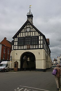
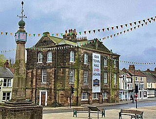
Bridgnorth Town Hall is a municipal building in the High Street, Bridgnorth, Shropshire, England. The town hall, which is a meeting place of Bridgnorth Town Council, is a Grade II* listed building.
Guisborough Town Hall is a municipal building on Westgate in Guisborough, North Yorkshire, England. The structure, which has mainly been used as a venue for magistrates' court hearings, is a Grade II listed building.
