
Peterborough is a cathedral city in the City of Peterborough district of Cambridgeshire, England. It was formerly governed as part of Northamptonshire and briefly Huntingdon and Peterborough.

Beeston is a town in the Borough of Broxtowe, Nottinghamshire, England, 3.4 miles (5.5 km) south-west of Nottingham city centre. To its north-east is the University of Nottingham's main campus, University Park. The pharmaceutical and retail chemist group Boots has its headquarters 0.6 miles (1 km) east of the centre of Beeston, on the border with Broxtowe and the City of Nottingham. To the south lie the River Trent and the village of Attenborough, with extensive wetlands.
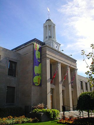
Peterborough is a city on the Otonabee River in Ontario, Canada, about 125 kilometres northeast of Toronto. According to the 2021 Census, the population of the City of Peterborough was 83,651. The population of the Peterborough Census Metropolitan Area (CMA), which includes the surrounding Townships of Selwyn, Cavan Monaghan, Otonabee-South Monaghan, and Douro-Dummer, was 128,624 in 2021. In 2021, Peterborough ranked 32nd among the country's 41 census metropolitan areas according to the CMA in Canada. The current mayor of Peterborough is Jeff Leal.

Portsea Island is a flat and low-lying natural island 24.5 square kilometres in area, just off the southern coast of Hampshire in England. Portsea Island contains the majority of the city of Portsmouth.

Homebush is a suburb in the Inner West of Sydney in the state of New South Wales, Australia. It is located 12 kilometres west of the Sydney central business district, in the local government area of the Municipality of Strathfield.

Swiss Cottage is an area of Hampstead in the London Borough of Camden, England. It is centred on the junction of Avenue Road and Finchley Road and includes Swiss Cottage tube station. Swiss Cottage lies 3.25 miles (5.23 km) north-northwest of Charing Cross. The area was named after a public house in the centre of it, known as "Ye Olde Swiss Cottage".It was visited by Queen Victoria’s fourth child.

Shard End is an area of Birmingham, England. It is also a ward within the formal district of Hodge Hill. Shard End borders Castle Bromwich to the north and Kingshurst to the east which are situated in the northern part of the neighbouring Metropolitan Borough of Solihull.

West Park is a suburb of north-west Leeds, West Yorkshire, England, north of Headingley. It is a mixed area of private suburban housing and suburban council estates. The name derives from its main park containing playing fields together with a conservation area of grassy meadow ending in woodland. The largest housing estate in West Park is Moor Grange.

Kallang is a planning area and residential zone located in the Central Region of Singapore.

Hulme is an inner city area and electoral ward of Manchester, England, immediately south of Manchester city centre. It has a significant industrial heritage.

Peterborough railway station serves the city of Peterborough, Cambridgeshire, England. It is 76 miles 29 chains (122.9 km) down the East Coast Main Line from London King's Cross. The station is a major interchange serving both the north–south ECML, as well as long-distance and local east–west services. The station is managed by London North Eastern Railway. Ticket gates came into use at the station in 2012.

Edinburgh Gardens is a large park located in the inner Melbourne suburb of North Fitzroy. It is bounded by Brunswick Street and St Georges Road to the west, the curve of Alfred Crescent to the north and east, and Freeman Street to the south. It was created from a grant of land in March 1862 by Queen Victoria and laid out by Clement Hodgkinson, who designed many of Melbourne's parks and gardens. At approximately 24 hectares in size, the park is large by inner urban standards.

Elections to the Preston City Council took place on 3 May 2007.

Old East York is a district of the city of Toronto, Ontario, Canada. It consists of the southern, urban, portion of the former borough of East York. Old East York is continuous and functionally integrated with the old City of Toronto, bounded by the old municipal boundary between East York and Old Toronto on the south, by the Don River Valley on the west and northwest, by Taylor-Massey Creek on the north, and Victoria Park Avenue in the east.
Shandon is an area of Edinburgh within North Merchiston approximately three miles west of the centre of Edinburgh. It is bounded by Slateford Road to the north, Harrison Road to the east, the Union Canal to the south and the Glasgow-Edinburgh Shotts Line and Suburban rail lines to the west.

Bretton is a settlement and civil parish on the north western edge of Peterborough, in the Peterborough district, in the ceremonial county of Cambridgeshire, England. Bretton has been designed as a green environment; the major roads are tree-lined and there are several large parks and playing fields. It consists of two main areas; North Bretton and South Bretton, these are divided by Bretton Centre. North Bretton has the larger population and is home to the industrial estates and most leisure facilities as well as the Crematorium. The main entrance to Milton Hall is from Bretton Way in South Bretton and Nene Park is accessed via an under pass beneath the A47.

Round Hill is an inner suburban area of Brighton, part of the coastal city of Brighton and Hove in England. The area contains a mix of privately owned and privately rented terraced housing, much of which has been converted for multiple occupancies, and small-scale commercial development. It was developed mostly in the late 19th century on an area of high land overlooking central Brighton and with good views in all directions, the area became a desirable middle-class suburb—particularly the large terraced houses of Roundhill Crescent and Richmond Road, and the exclusive Park Crescent—and within a few decades the whole of the hill had been built up with smaller terraces and some large villas.
Roundhill Crescent is a late-19th-century housing development in Round Hill, an inner suburb of the English coastal city of Brighton and Hove. Partly developed in the 1860s with large terraced houses on a steeply sloping open hillside, the crescent—which "curves and changes height dramatically along its length"—was finished two decades later and now forms the centrepiece of the Round Hill conservation area. Smaller houses completed the composition in the 1880s, and England's first hospital for the treatment of mental illness was founded in the crescent in 1905. The five original sets of houses from the 1860s have been listed at Grade II by English Heritage for their architectural and historical importance, and the crescent occupies a prominent place on Brighton's skyline.

Montpelier is an inner suburban area of Brighton, part of the English city and seaside resort of Brighton and Hove. Developed together with the adjacent Clifton Hill area in the mid-19th century, it forms a high-class, architecturally cohesive residential district with "an exceptionally complete character". Stucco-clad terraced housing and villas predominate, but two of the city's most significant Victorian churches and a landmark hospital building are also in the area, which lies immediately northwest of Brighton city centre and spreads as far as the ancient parish boundary with Hove.

Prestonville is a largely residential area in the northwest of Brighton, part of the English city of Brighton and Hove. It covers a long, narrow and steeply sloping ridge of land between the Brighton Main Line and Dyke Road, two major transport corridors which run north-northwestwards from the centre of Brighton. Residential development started in the 1860s and spread northwards, further from central Brighton, over the next six decades. The area is characterised by middle-class and upper-middle-class housing in various styles, small-scale commercial development and long eastward views across the city. Two Anglican churches serve Prestonville—one at each end of the area—and there are several listed buildings.

