
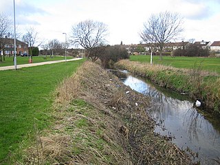
Witham is a town and civil parish in the Braintree district, in the county of Essex, England. In the 2011 census, it had a population of 25,353. It is twinned with the town of Waldbröl, Germany. Witham stands on the Roman road between the cities of Chelmsford and Colchester. The River Brain runs through the town and joins the River Blackwater on the outskirts.

Werrington is a residential area of the city of Peterborough, in the ceremonial county of Cambridgeshire, England. For electoral purposes it comprises North Werrington and South Werrington wards. Werrington spans an area of two and a half square miles (6 km2) and has a population of 14,800.

Orton is a suburb of the City of Peterborough, in Cambridgeshire, England, about 3 miles (4.8 km) south west of Peterborough city centre to the south of the River Nene. It is located on the route of the A1.
The A15 is a major road in England. It runs north from Peterborough via Market Deeping, Bourne, Sleaford and Lincoln along a variety of ancient, Roman, and Turnpike alignments before it is interrupted at its junction with the M180 near Scawby. The road restarts 10 miles (16 km) east, and then continues north past Barton-upon-Humber, crossing the Humber on the Humber Bridge before terminating at Hessle near Kingston upon Hull.
Chilwell is a suburban area in the borough of Broxtowe in Nottinghamshire, England. It lies on the west side of the town of Beeston and is 4 miles (6.4 km) south-west of the centre of Nottingham.
Houghton is a village and former civil parish, now in the parish of Houghton and Wyton, in Cambridgeshire, England, approximately 3 miles (5 km) east of Huntingdon on the A1123 road, and south of RAF Wyton. It lies on the north bank of the River Great Ouse, by Houghton Mill.
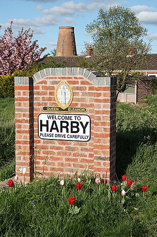
Harby is a village and civil parish in the Newark and Sherwood district of Nottinghamshire, England. It is close to Doddington, Lincolnshire, and is the easternmost settlement in Nottinghamshire, the boundary separating the two. According to the 2011 census, it had a population of 336, up from 289 at the 2001 census. It increased to 346 at the 2021 census.
Chesterton is a small village and civil parish of exactly 56 households in Cambridgeshire, England. The village lies approximately 5 miles (8 km) west-southwest of central Peterborough, near the city's Alwalton district. Chesterton is situated within Huntingdonshire which is a non-metropolitan district of Cambridgeshire as well as being a historic county of England.

Coton is a hamlet and former civil parish, now in the parish of Ravensthorpe, in the West Northamptonshire district, in the ceremonial county of Northamptonshire, England. It is located between Guilsborough and Ravensthorpe. Coton Manor is a popular visitor attraction for its gardens and bluebell woods. In 1931 the parish had a population of 83.

Oakington is a small rural Anglo-Saxon village and former civil parish, now in the parish of Oakington and Westwick, in the South Cambridgeshire district, in the county of Cambridgeshire, England. It is seven miles (11 km) north-west of Cambridge. In 1961 the parish had a population of 698.
Limbury is a suburb of Luton, in the Luton district, in the ceremonial county of Bedfordshire, England, and was formerly a village before Luton expanded around it. The area is roughly bounded by Bramingham Road to the north, Marsh Road to the south, Bramingham Road to the west, and Catsbrook Road, Runfold Avenue, Grosvenor Road, Bancroft Road and Blundell Road to the east.

Leagrave is a former village and now a suburb of Luton, in the Luton district, in the ceremonial county of Bedfordshire, England, in the northwest of the town. The current council ward is roughly bounded by Vincent Road, Torquay Drive and High Street to the north, Roman Road and Stoneygate Road to the south, the M1 to the west, and Marsh Road and Leagrave Park to the east.

Glinton is a village in the north of the City of Peterborough unitary authority area in Cambridgeshire, England. Historically in Northamptonshire, it has a population of 3,130 and consists of about 1,200 dwellings. It is separated from the urban sprawl of Peterborough and the new township of Werrington by the A15, the Peterborough bypass.

Burcot is a hamlet in the civil parish of Clifton Hampden, in the South Oxfordshire district, in the county of Oxfordshire, England. It is on the left bank of the River Thames. In 1931 the parish had a population of 187.

Walton is a residential area and electoral ward of the city of Peterborough in the ceremonial county of Cambridgeshire, England. Manufacturers of industrial machinery, Peter Brotherhood, relocated here from London in 1906.

Lutley is a hamlet near Halesowen in the Dudley district, in the county of the West Midlands, England. Lutley Mill is nearby in Halesowen and is also the name of a local pub. Lutley Mill is situated on Puddings Brook. The Lutley Gutter runs through Lutley. In 1951 the parish had a population of 457.

Bretton is a settlement and civil parish on the north western edge of Peterborough, in the Peterborough district, in the ceremonial county of Cambridgeshire, England. Bretton has been designed as a green environment; the major roads are tree-lined and there are several large parks and playing fields. It consists of two main areas; North Bretton and South Bretton, these are divided by Bretton Centre. North Bretton has the larger population and is home to the industrial estates and most leisure facilities as well as the Crematorium. The main entrance to Milton Hall is from Bretton Way in South Bretton and Nene Park is accessed via an under pass beneath the A47.
Tiddington is a village in the civil parish of Tiddington-with-Albury, in the South Oxfordshire district, in Oxfordshire, England. It is about 3+1⁄2 miles (5.6 km) west of Thame, on the A418 road between Thame and Oxford. The 2011 Census recorded Tiddington-with-Albury's population as 683. Tiddington is on the county boundary with Buckinghamshire. It was a manor and hamlet of the parish of Albury, although for most of its history it has been a larger place than Albury. In 1866 Tiddington became a separate civil parish, on 1 April 1932 the parish was merged with Albury to form "Tiddington with Albury". In 1931 the parish had a population of 163.

North Clifton is a village and civil parish about 12 miles north of Newark-on-Trent, in the Newark and Sherwood district, within the county of Nottinghamshire, England. In 2011, the parish had a population of 216, and this dropped to 176 at the 2021 census. The parish touches Thorney, Fledborough, Newton on Trent, South Clifton and Ragnall.

