
Crowland or Croyland is a town in the South Holland district of Lincolnshire, England. It is situated between Peterborough and Spalding. Crowland contains two sites of historical interest, Crowland Abbey and Trinity Bridge.

The Fens or Fenlands in eastern England are a naturally marshy region supporting a rich ecology and numerous species. Most of the fens were drained centuries ago, resulting in a flat, dry, low-lying agricultural region supported by a system of drainage channels and man-made rivers and automated pumping stations. There have been unintended consequences to this reclamation, as the land level has continued to sink and the dykes have been built higher to protect it from flooding.
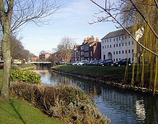
Spalding is a market town on the River Welland in the South Holland district of Lincolnshire, England. The town had a population of 34,113 at the 2017 census. The town is the administrative centre of the South Holland District. The town is located between the cities of Peterborough and Lincoln, as well as the towns of Bourne, March, Boston, Wisbech, Holbeach and Sleaford.

Holbeach is a market town and civil parish in the South Holland District in Lincolnshire, England. The town lies 8 miles (13 km) from Spalding; 17 miles (27 km) from Boston; 20 miles (32 km) from King's Lynn; 23 miles (37 km) from Peterborough; and 43 miles (69 km) by road from Lincoln. It is on the junction of the A151 and A17.

Gedney is a village, civil parish and electoral ward in the South Holland district of Lincolnshire, England. It is just to the south of the A17 Boston to King's Lynn road, 2 miles (3.2 km) east from Holbeach and 2 miles (3.2 km) north-west from Long Sutton. The parish stretches east to The Wash, its villages and hamlets including Dawsmere, Gedney Broadgate, Gedney Drove End, Gedney Dyke, Gedney Marsh, and the geographic extension of Gedney Church End.

Frampton is a village and civil parish in the Borough of Boston, Lincolnshire, England. The village is situated approximately 3 miles (5 km) south from the town of Boston and to the east of the A16, which runs along the townlands. The village lies on the edge of one of the great marine creek levees formed during the Bronze Age, 2 to 2.5 miles from the modern salt marsh. The population of the civil parish at the 2011 census was 1,299.

The A151 road is relatively minor part of the British road system. It lies entirely in the county of Lincolnshire, England. Its western end lies at coordinates 52°48.1892′N0°36.5179′W otherwise, grid reference SK938238.

Bicker is a village in the Borough of Boston, Lincolnshire, England. The population of the village was 941 at the 2011 census. It is situated approximately 9 miles (10 km) west-south-west from Boston, and on the A52 road.

Morton and Hanthorpe is a civil parish, formerly known as Morton by Bourne in the South Kesteven district of Lincolnshire, England. It is situated 2 miles (3 km) north from Bourne, and 14 miles (23 km) south-east from Grantham. According to the 2011 Census the parish had a population of 2,406.
Dowsby is a village and civil parish in the South Kesteven district of Lincolnshire, England. It is situated on the western edge of The Fens at the junction of the east–west B1397 road and the north–south B1177. It is 1 mile (1.6 km) north-east from Rippingale and just south of Pointon. The civil parish includes the hamlet of Graby. Nearby to the east, along the B1397 at Dowsby Fen, is Car Dyke. The civil parish population taken at the 2011 census was 204.

Thurlby is a village and civil parish in the South Kesteven district of Lincolnshire, England. It is situated just west of the A15 road, 2 miles (3 km) south from the town of Bourne, and on the edge of the Lincolnshire Fens. It is sometimes referred to as Thurlby by Bourne to distinguish it from other villages in Lincolnshire with the same name. Thurlby and the hamlet of Northorpe to its north are conjoined. The parish had a population of 2,136 at the 2001 census and 2,153 at the 2011 census.

Gosberton is a village and civil parish in the South Holland district of Lincolnshire, England. It is situated 9 miles (14.5 km) south-west of Boston, 6 miles (10 km) north of Spalding and 9 miles (14 km) north-west of Holbeach. The parish includes the villages of Gosberton Clough and Risegate, and the hamlets of Westhorpe and Gosberton Cheal. The population of Gosberton, which was approximately 2,500, increased to 2,958 at the 2011 Census.

Tetney is a village in the East Lindsey district of Lincolnshire, England, just west of the Prime Meridian.

Deeping St Nicholas is a village in Lincolnshire, England, on the A1175 road between The Deepings and Spalding. Unlike Market Deeping, which is in South Kesteven district, Deeping St Nicholas is in South Holland.

Haconby is a village and civil parish in the South Kesteven district of Lincolnshire, England. The population of the civil parish at the 2001 census was 448 increasing to 532 at the 2011 census. It is situated on the western edge of the Lincolnshire Fens, 3 miles (5 km) north from Bourne.

South Holland IDB is an English internal drainage board set up under the terms of the Land Drainage Act 1930. It has responsibility for the land drainage of 148.43 square miles (384.4 km2) of low-lying land in South Lincolnshire. It is unusual as its catchment area is the same as the area of the drainage district, and so it does not have to deal with water flowing into the area from surrounding higher ground. No major rivers flow through the area, although the district is bounded by the River Welland to the west and the River Nene to the east.

Holbeach Clough is a fenland village in the South Holland district of Lincolnshire, England. It is just under 2 miles (3 km) north from the market town of Holbeach, and on the A17 road. The village is almost conjoined at the east to the village of Holbeach Bank. The village is part of the Holbeach civil parish, and is at the south-west edge of Holbeach Marsh.

Holbeach Marsh is a fenland area in the South Holland district of Lincolnshire, England.

Shepeau Stow is a hamlet in the South Holland district of Lincolnshire, England. It is at the north-east edge of Whaplode civil parish, where it adjoins Crowland civil parish, and on the B1166 Hull's Drove road. Shepeau Stow is 7 miles (11 km) south-east from Spalding and 4 miles (6 km) east from Crowland.


